Tapalpa elevation
Tapalpa (Jalisco), Mexico elevation is 2062 meters and Tapalpa elevation in feet is 6765 ft above sea level [src 1]. Tapalpa is a seat of a second-order administrative division (feature code) with elevation that is 748 meters (2454 ft) bigger than average city elevation in Mexico.
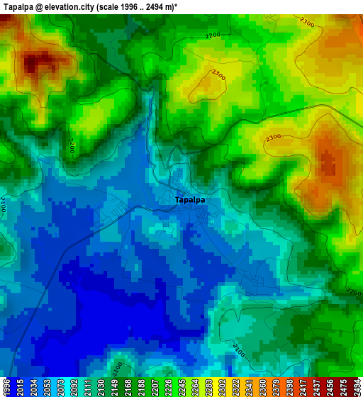
Below is the Elevation map of Tapalpa, which displays elevation range with different colors. Scale of the first map is from 1996 to 2494 m (6549 to 8182 ft) with average elevation of 2151.1 meters (=7057 ft) [note 1]
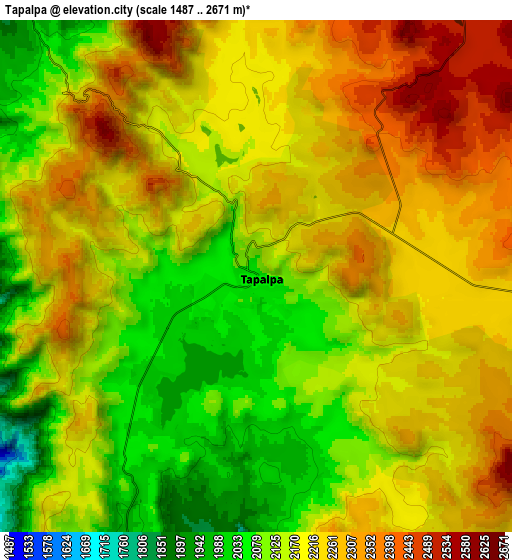
These maps also provides idea of topography and contour of this city, they are displayed at different zoom levels. More info about maps, scale and edge coordinates you can find below images.
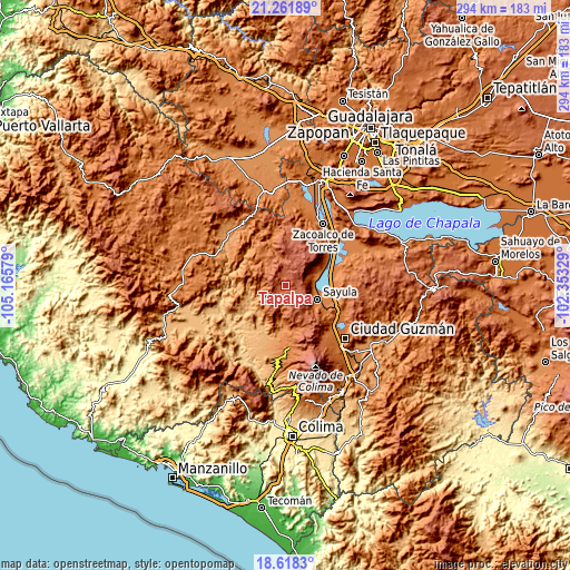
| \ | Map #1 | Map #2 | Topo.Map |
| Scale [m] | 1996..2494 m | 1487..2671 m | × |
| Scale [ft] | 6549..8182 ft | 4879..8763 ft | × |
| Average | 2151.1 m = 7057 ft | 2200.9 m = 7221 ft | × |
| Width | 9.19 km = 5.7 mi | 18.37 km = 11.4 mi | 293.9 km = 182.6 mi |
| Height | 9.19 km = 5.7 mi | 18.37 km = 11.4 mi | 294 km = 182.7 mi |
| ↑Max Latitude | 19.986934° | 20.028227° | 21.26189° |
| Latitude at center | 19.94563° | 19.94563° | 19.94563° |
| ↓Min Latitude | 19.904315° | 19.86299° | 18.6183° |
| ← Min Longitude | -103.803485° | -103.847431° | -105.16579° |
| Longitude center | -103.75954° | -103.75954° | -103.75954° |
| →Max Longitude | -103.715595° | -103.671649° | -102.35329° |
Nearby cities:
Cities around Tapalpa sort by population:
• Sayula elevation 1373 m
18.1 km,  112°
112°
• Usmajac 1364 m
24.2 km, 109°
• Atemajac de Brizuela 2354 m
21.6 km,  9°
9°
• Atoyac 1356 m
26.4 km,  74°
74°
• San Gabriel 1266 m
22 km,  182°
182°
• Chiquilistlán 1730 m
19 km,  326°
326°
• Juanacatlán 2518 m
12.3 km,  38°
38°
• Amacueca 1433 m
18.2 km, 66°
• Techaluta de Montenegro 1413 m
26 km,  56°
56°
• Tepec 1600 m
13.3 km, 68°
• Jiquilpan 1301 m
18.7 km,  186°
186°
• Atacco 2045 m
2.8 km,  139°
139°
Multilingual:
 En español:
Tapalpa elevación 2062 m.
 En France:
Tapalpa élévation 2062 m.
 Auf Deutsch:
Tapalpa höhe über dem Meeresspiegel ist 2062 m.

Sources and notes:
- [note 1] Map square and city borders are not equal. Map elevation data is calculated only from area inside that square.
- [src 1] Elevation data from geonames database provided with same terms of usage.
- [src 2] The elevation map of Tapalpa is generated using elevation data from NASA's 3 arcsec (90m) resolution SRTM data.
- [src 3] Base (background) map © OpenStreetMap contributors tiles are generated by Geofabrik and OpenTopoMap.
Copyright & License:
This Tapalpa Elevation Map is licensed under CC BY-SA. You may reuse any part from this page, if you give a proper credit by linking to this URL:
 More info on terms of use page.