Tarécuato elevation
Tarécuato (State of Mexico), Mexico elevation is 1976 meters and Tarécuato elevation in feet is 6483 ft above sea level [src 1]. Tarécuato is a populated place (feature code) with elevation that is 662 meters (2172 ft) bigger than average city elevation in Mexico.
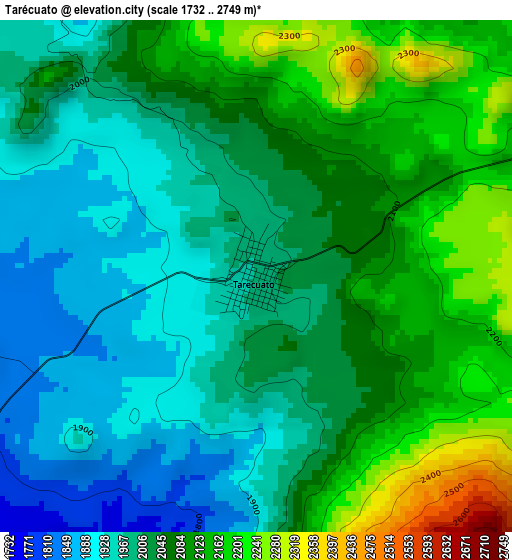
Below is the Elevation map of Tarécuato, which displays elevation range with different colors. Scale of the first map is from 1732 to 2749 m (5682 to 9019 ft) with average elevation of 2041.9 meters (=6699 ft) [note 1]
These maps also provides idea of topography and contour of this city, they are displayed at different zoom levels. More info about maps, scale and edge coordinates you can find below images.
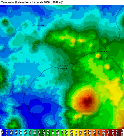
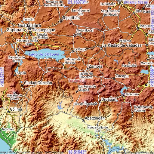
| \ | Map #1 | Map #2 | Topo.Map |
| Scale [m] | 1732..2749 m | 1666..2882 m | × |
| Scale [ft] | 5682..9019 ft | 5466..9455 ft | × |
| Average | 2041.9 m = 6699 ft | 2002.6 m = 6570 ft | × |
| Width | 9.19 km = 5.7 mi | 18.38 km = 11.4 mi | 294.1 km = 182.7 mi |
| Height | 9.19 km = 5.7 mi | 18.38 km = 11.4 mi | 294.1 km = 182.7 mi |
| ↑Max Latitude | 19.884921° | 19.92624° | 21.16073° |
| Latitude at center | 19.84359° | 19.84359° | 19.84359° |
| ↓Min Latitude | 19.802249° | 19.760897° | 18.51543° |
| ← Min Longitude | -102.508795° | -102.552741° | -103.8711° |
| Longitude center | -102.46485° | -102.46485° | -102.46485° |
| →Max Longitude | -102.420905° | -102.376959° | -101.0586° |
Nearby cities:
Cities around Tarécuato sort by population:
• Jacona de Plancarte elevation 1596 m
20.4 km,  53°
53°
• Santiago Tangamandapio 1673 m
12.8 km,  13°
13°
• Tingüindín 1693 m
11.7 km,  188°
188°
• Chavinda 1572 m
18.1 km,  1°
1°
• La Cantera 2147 m
6.3 km,  69°
69°
• Tacátzcuaro 1619 m
15.3 km,  214°
214°
• J. Jesús Díaz Tzirio 2257 m
11.1 km,  140°
140°
• Tocumbo 1610 m
16.9 km,  201°
201°
• San Antonio Guaracha 1607 m
14.8 km,  320°
320°
• Los Hucuares 1836 m
7.1 km,  331°
331°
• Tengüecho 2186 m
12.7 km,  92°
92°
• El Guayabito 1731 m
12 km, 10°
Multilingual:
 En español:
Tarécuato elevación 1976 m.
 En France:
Tarécuato élévation 1976 m.
 Auf Deutsch:
Tarécuato höhe über dem Meeresspiegel ist 1976 m.

Sources and notes:
- [note 1] Map square and city borders are not equal. Map elevation data is calculated only from area inside that square.
- [src 1] Elevation data from geonames database provided with same terms of usage.
- [src 2] The elevation map of Tarécuato is generated using elevation data from NASA's 3 arcsec (90m) resolution SRTM data.
- [src 3] Base (background) map © OpenStreetMap contributors tiles are generated by Geofabrik and OpenTopoMap.
Copyright & License:
This Tarécuato Elevation Map is licensed under CC BY-SA. You may reuse any part from this page, if you give a proper credit by linking to this URL:
 More info on terms of use page.