Chavinda elevation
Chavinda (Michoacán), Mexico elevation is 1572 meters and Chavinda elevation in feet is 5157 ft above sea level [src 1]. Chavinda is a seat of a second-order administrative division (feature code) with elevation that is 258 meters (846 ft) bigger than average city elevation in Mexico.
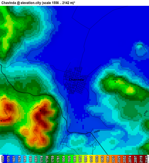
Below is the Elevation map of Chavinda, which displays elevation range with different colors. Scale of the first map is from 1556 to 2142 m (5105 to 7028 ft) with average elevation of 1669.5 meters (=5477 ft) [note 1]
These maps also provides idea of topography and contour of this city, they are displayed at different zoom levels. More info about maps, scale and edge coordinates you can find below images.
| \ | Map #1 | Map #2 | Topo.Map |
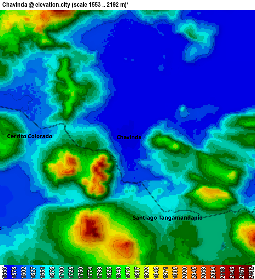
| Scale [m] | 1556..2142 m | 1553..2192 m | × |
| Scale [ft] | 5105..7028 ft | 5095..7192 ft | × |
| Average | 1669.5 m = 5477 ft | 1692.4 m = 5552 ft | × |
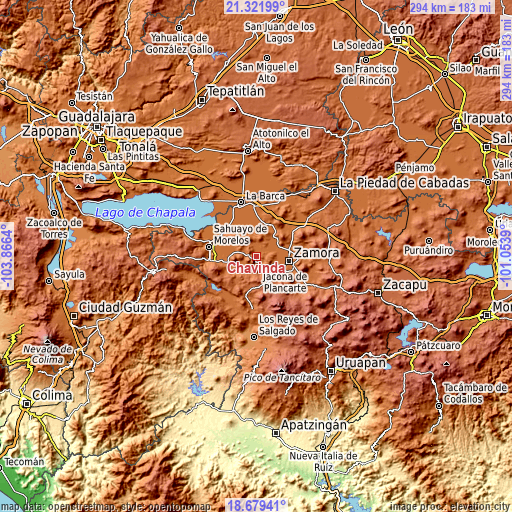
| Width | 9.18 km = 5.7 mi | 18.37 km = 11.4 mi | 293.8 km = 182.6 mi |
| Height | 9.18 km = 5.7 mi | 18.37 km = 11.4 mi | 293.8 km = 182.6 mi |
| ↑Max Latitude | 20.047538° | 20.088815° | 21.32199° |
| Latitude at center | 20.00625° | 20.00625° | 20.00625° |
| ↓Min Latitude | 19.964951° | 19.923641° | 18.67941° |
| ← Min Longitude | -102.504095° | -102.548041° | -103.8664° |
| Longitude center | -102.46015° | -102.46015° | -102.46015° |
| →Max Longitude | -102.416205° | -102.372259° | -101.0539° |
Nearby cities:
Cities around Chavinda sort by population:
• Santiago Tangamandapio elevation 1673 m
6.2 km,  155°
155°
• Ario de Rayón 1569 m
11.9 km,  79°
79°
• Villamar 1536 m
14.3 km,  276°
276°
• La Sauceda 1575 m
15.5 km,  50°
50°
• El Platanal 1530 m
13.8 km,  296°
296°
• La Plaza del Limón 1540 m
14.7 km,  11°
11°
• San Antonio Guaracha 1607 m
12 km,  236°
236°
• La Esperanza 1565 m
7.5 km,  43°
43°
• Los Hucuares 1836 m
12.5 km,  198°
198°
• Tecomatán 1529 m
12.7 km,  342°
342°
• El Paracho 1537 m
13.1 km,  330°
330°
• El Guayabito 1731 m
6.5 km,  165°
165°
Multilingual:
 En español:
Villa Chavínda, Chavínda, Chavinda elevación 1572 m.
 En France:
Chavinda élévation 1572 m.
 Auf Deutsch:
Chavinda höhe über dem Meeresspiegel ist 1572 m.

Sources and notes:
- [note 1] Map square and city borders are not equal. Map elevation data is calculated only from area inside that square.
- [src 1] Elevation data from geonames database provided with same terms of usage.
- [src 2] The elevation map of Chavinda is generated using elevation data from NASA's 3 arcsec (90m) resolution SRTM data.
- [src 3] Base (background) map © OpenStreetMap contributors tiles are generated by Geofabrik and OpenTopoMap.
Copyright & License:
This Chavinda Elevation Map is licensed under CC BY-SA. You may reuse any part from this page, if you give a proper credit by linking to this URL:
 More info on terms of use page.