El Tepetate elevation
El Tepetate (San Luis Potosí, Villa de Arriaga), Mexico elevation is 2178 meters and El Tepetate elevation in feet is 7146 ft above sea level [src 1]. El Tepetate is a populated place (feature code) with elevation that is 864 meters (2835 ft) bigger than average city elevation in Mexico.
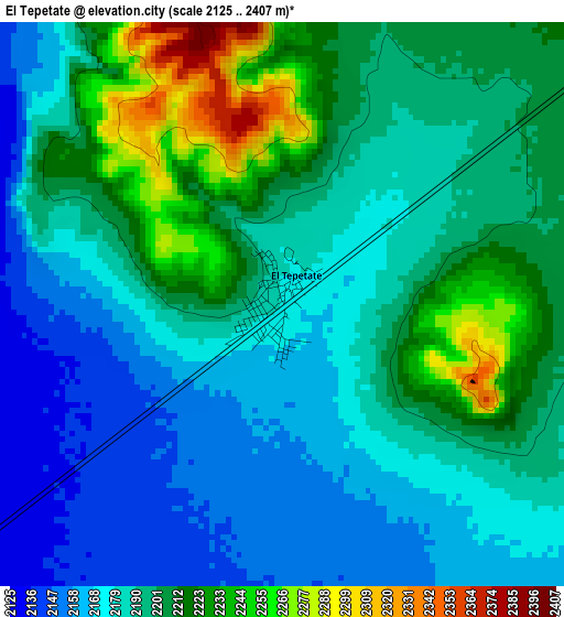
Below is the Elevation map of El Tepetate, which displays elevation range with different colors. Scale of the first map is from 2125 to 2407 m (6972 to 7897 ft) with average elevation of 2193.6 meters (=7197 ft) [note 1]
These maps also provides idea of topography and contour of this city, they are displayed at different zoom levels. More info about maps, scale and edge coordinates you can find below images.
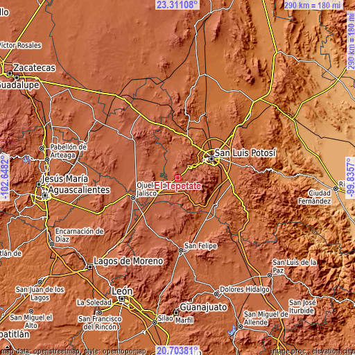
| \ | Map #1 | Topo.Map |
| Scale [m] | 2125..2407 m | × |
| Scale [ft] | 6972..7897 ft | × |
| Average | 2193.6 m = 7197 ft | × |
| Width | 9.06 km = 5.6 mi | 289.9 km = 180.1 mi |
| Height | 9.06 km = 5.6 mi | 289.9 km = 180.1 mi |
| ↑Max Latitude | 22.054176° | 23.31108° |
| Latitude at center | 22.01344° | 22.01344° |
| ↓Min Latitude | 21.972693° | 20.70381° |
| ← Min Longitude | -101.285895° | -102.6482° |
| Longitude center | -101.24195° | -101.24195° |
| →Max Longitude | -101.198005° | -99.8357° |
Nearby cities:
Cities around El Tepetate sort by population:
• Villa de Arriaga elevation 2169 m
18.5 km,  231°
231°
• Escalerillas 1955 m
20.5 km,  57°
57°
• Laguna de Guadalupe 2230 m
26.5 km,  206°
206°
• Carranco 1932 m
26.2 km,  145°
145°
• Bledos 1960 m
23.1 km, 145°
• Santa Elena 2243 m
27.8 km,  261°
261°
• Suspiro Picacho 1981 m
27.2 km,  36°
36°
• San Francisco 2208 m
8.7 km,  100°
100°
• Guadalupe Victoria 1991 m
24.3 km,  46°
46°
• Pozuelos 2100 m
15.6 km, 57°
• La Mesa de los Conejos 2056 m
21.9 km, 62°
• Paso Blanco 1963 m
27.8 km, 39°
Multilingual:
 En español:
El Tepetate elevación 2178 m.
 En France:
El Tepetate élévation 2178 m.
 Auf Deutsch:
El Tepetate höhe über dem Meeresspiegel ist 2178 m.

Sources and notes:
- [note 1] Map square and city borders are not equal. Map elevation data is calculated only from area inside that square.
- [src 1] Elevation data from geonames database provided with same terms of usage.
- [src 2] The elevation map of El Tepetate is generated using elevation data from NASA's 3 arcsec (90m) resolution SRTM data.
- [src 3] Base (background) map © OpenStreetMap contributors tiles are generated by Geofabrik and OpenTopoMap.
Copyright & License:
This El Tepetate Elevation Map is licensed under CC BY-SA. You may reuse any part from this page, if you give a proper credit by linking to this URL:
 More info on terms of use page.