Bledos elevation
Bledos (San Luis Potosí, Villa de Reyes), Mexico elevation is 1960 meters and Bledos elevation in feet is 6430 ft above sea level [src 1]. Bledos is a populated place (feature code) with elevation that is 646 meters (2119 ft) bigger than average city elevation in Mexico.
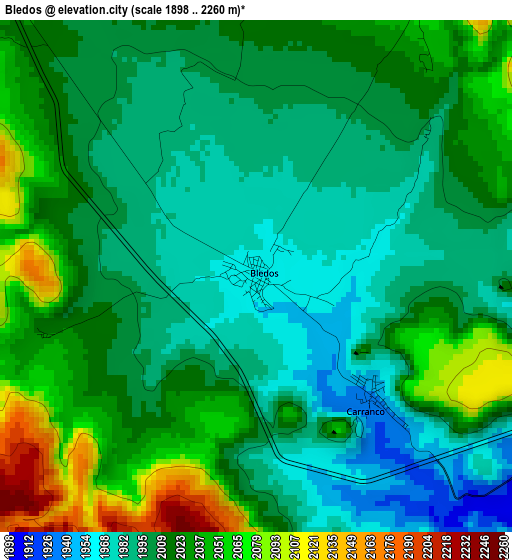
Below is the Elevation map of Bledos, which displays elevation range with different colors. Scale of the first map is from 1898 to 2260 m (6227 to 7415 ft) with average elevation of 2013.9 meters (=6607 ft) [note 1]
These maps also provides idea of topography and contour of this city, they are displayed at different zoom levels. More info about maps, scale and edge coordinates you can find below images.
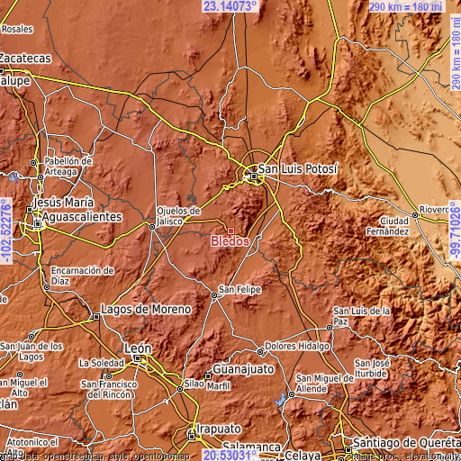
| \ | Map #1 | Topo.Map |
| Scale [m] | 1898..2260 m | × |
| Scale [ft] | 6227..7415 ft | × |
| Average | 2013.9 m = 6607 ft | × |
| Width | 9.07 km = 5.6 mi | 290.3 km = 180.4 mi |
| Height | 9.07 km = 5.6 mi | 290.3 km = 180.4 mi |
| ↑Max Latitude | 21.882265° | 23.14073° |
| Latitude at center | 21.84148° | 21.84148° |
| ↓Min Latitude | 21.800683° | 20.53031° |
| ← Min Longitude | -101.160455° | -102.52276° |
| Longitude center | -101.11651° | -101.11651° |
| →Max Longitude | -101.072565° | -99.71026° |
Nearby cities:
Cities around Bledos sort by population:
• Villa de Reyes elevation 1815 m
19.3 km,  102°
102°
• El Rosario 1873 m
23 km,  121°
121°
• Carranco 1932 m
3.1 km,  139°
139°
• La Ventilla 1865 m
11.6 km,  130°
130°
• Ejido el Saucillo 1870 m
12.6 km,  92°
92°
• Ejido Gogorrón (Ex-Hacienda de Gogorrón) 1807 m
21.2 km, 90°
• Guadalupe 1835 m
20.1 km, 133°
• Emiliano Zapata 1834 m
22.7 km,  66°
66°
• San Francisco 2208 m
18.1 km,  345°
345°
• Rodrigo 1874 m
17.7 km, 71°
• Alberto Carrera Torres 1841 m
13.2 km, 125°
• El Zapote 1883 m
13.7 km,  149°
149°
Multilingual:
 En español:
Bledos elevación 1960 m.
 En France:
Bledos élévation 1960 m.


Sources and notes:
- [note 1] Map square and city borders are not equal. Map elevation data is calculated only from area inside that square.
- [src 1] Elevation data from geonames database provided with same terms of usage.
- [src 2] The elevation map of Bledos is generated using elevation data from NASA's 3 arcsec (90m) resolution SRTM data.
- [src 3] Base (background) map © OpenStreetMap contributors tiles are generated by Geofabrik and OpenTopoMap.
Copyright & License:
This Bledos Elevation Map is licensed under CC BY-SA. You may reuse any part from this page, if you give a proper credit by linking to this URL:
 More info on terms of use page.