Tlacote el Bajo elevation
Tlacote el Bajo (Querétaro), Mexico elevation is 1854 meters and Tlacote el Bajo elevation in feet is 6083 ft above sea level [src 1]. Tlacote el Bajo is a populated place (feature code) with elevation that is 540 meters (1772 ft) bigger than average city elevation in Mexico.
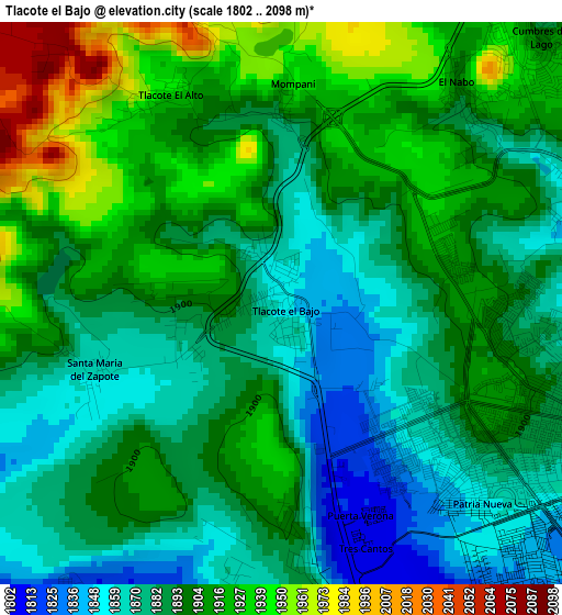
Below is the Elevation map of Tlacote el Bajo, which displays elevation range with different colors. Scale of the first map is from 1802 to 2098 m (5912 to 6883 ft) with average elevation of 1896.4 meters (=6222 ft) [note 1]
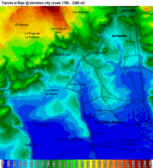
These maps also provides idea of topography and contour of this city, they are displayed at different zoom levels. More info about maps, scale and edge coordinates you can find below images.
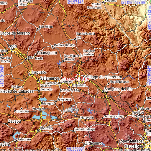
| \ | Map #1 | Map #2 | Topo.Map |
| Scale [m] | 1802..2098 m | 1786..2366 m | × |
| Scale [ft] | 5912..6883 ft | 5860..7762 ft | × |
| Average | 1896.4 m = 6222 ft | 1927.3 m = 6323 ft | × |
| Width | 9.14 km = 5.7 mi | 18.29 km = 11.4 mi | 292.6 km = 181.8 mi |
| Height | 9.14 km = 5.7 mi | 18.29 km = 11.4 mi | 292.6 km = 181.8 mi |
| ↑Max Latitude | 20.702503° | 20.743605° | 21.9714° |
| Latitude at center | 20.66139° | 20.66139° | 20.66139° |
| ↓Min Latitude | 20.620266° | 20.57913° | 19.33999° |
| ← Min Longitude | -100.551635° | -100.595581° | -101.91394° |
| Longitude center | -100.50769° | -100.50769° | -100.50769° |
| →Max Longitude | -100.463745° | -100.419799° | -99.10144° |
Nearby cities:
Cities around Tlacote el Bajo sort by population:
• Juriquilla elevation 1907 m
7.9 km,  43°
43°
• San Pedro Mártir 1823 m
6.2 km,  141°
141°
• El Salitre 1846 m
8.8 km,  86°
86°
• Colinas de Santa Cruz Segunda Sección 1839 m
6 km,  134°
134°
• San Miguelito 2073 m
8.4 km,  3°
3°
• El Castillo 1809 m
9.1 km,  170°
170°
• El Nabo 1905 m
4.6 km, 38°
• San Francisco de la Palma 1892 m
0.8 km,  261°
261°
• Rancho Bellavista [Fraccionamiento] 1798 m
8.6 km, 135°
• Sergio Villaseñor 1969 m
9.2 km,  101°
101°
• Patria Nueva 1856 m
4.6 km, 135°
• Mompaní 1938 m
3.4 km, 1°
Multilingual:
 En español:
Tlacote el Bajo elevación 1854 m.
 En France:
Tlacote el Bajo élévation 1854 m.
 Auf Deutsch:
Tlacote el Bajo höhe über dem Meeresspiegel ist 1854 m.

Sources and notes:
- [note 1] Map square and city borders are not equal. Map elevation data is calculated only from area inside that square.
- [src 1] Elevation data from geonames database provided with same terms of usage.
- [src 2] The elevation map of Tlacote el Bajo is generated using elevation data from NASA's 3 arcsec (90m) resolution SRTM data.
- [src 3] Base (background) map © OpenStreetMap contributors tiles are generated by Geofabrik and OpenTopoMap.
Copyright & License:
This Tlacote el Bajo Elevation Map is licensed under CC BY-SA. You may reuse any part from this page, if you give a proper credit by linking to this URL:
 More info on terms of use page.