Tonila elevation
Tonila (Jalisco), Mexico elevation is 1161 meters and Tonila elevation in feet is 3809 ft above sea level [src 1]. Tonila is a populated place (feature code) with elevation that is 153 meters (502 ft) smaller than average city elevation in Mexico.
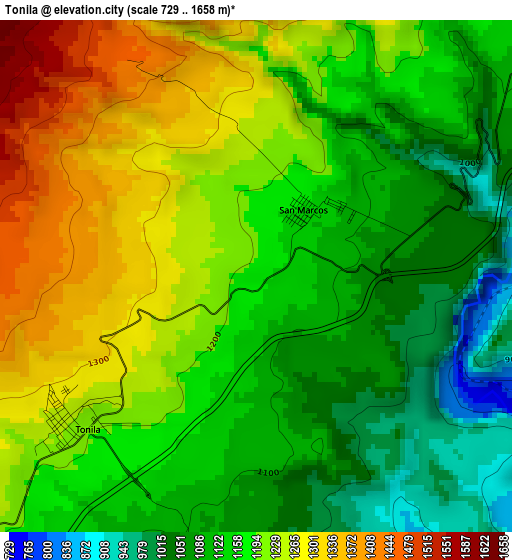
Below is the Elevation map of Tonila, which displays elevation range with different colors. Scale of the first map is from 729 to 1658 m (2392 to 5440 ft) with average elevation of 1175.2 meters (=3856 ft) [note 1]
These maps also provides idea of topography and contour of this city, they are displayed at different zoom levels. More info about maps, scale and edge coordinates you can find below images.
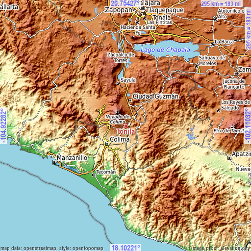
| \ | Map #1 | Topo.Map |
| Scale [m] | 729..1658 m | × |
| Scale [ft] | 2392..5440 ft | × |
| Average | 1175.2 m = 3856 ft | × |
| Width | 9.22 km = 5.7 mi | 294.9 km = 183.2 mi |
| Height | 9.22 km = 5.7 mi | 294.9 km = 183.2 mi |
| ↑Max Latitude | 19.475086° | 20.75427° |
| Latitude at center | 19.43365° | 19.43365° |
| ↓Min Latitude | 19.392203° | 18.10221° |
| ← Min Longitude | -103.560515° | -104.92282° |
| Longitude center | -103.51657° | -103.51657° |
| →Max Longitude | -103.472625° | -102.11032° |
Nearby cities:
Cities around Tonila sort by population:
• Tuxpan elevation 1142 m
20 km,  47°
47°
• Zapotiltic 1318 m
23.9 km,  25°
25°
• Tecalitlán 1132 m
22.4 km,  79°
79°
• Quesería 1255 m
7.8 km,  228°
228°
• Cuauhtémoc 946 m
14.8 km,  217°
217°
• Cofradía 1394 m
3.5 km,  269°
269°
• Suchitlán 1058 m
21.4 km,  252°
252°
• San Marcos 1144 m
1.7 km,  37°
37°
• El Trapiche 654 m
23 km, 221°
• Alcaraces 1158 m
10 km, 219°
• Cofradía de Suchitlán 1295 m
19.5 km,  262°
262°
• La Higuera 989 m
11.3 km,  95°
95°
Multilingual:
 En español:
Tonila elevación 1161 m.
 En France:
Tonila élévation 1161 m.


Sources and notes:
- [note 1] Map square and city borders are not equal. Map elevation data is calculated only from area inside that square.
- [src 1] Elevation data from geonames database provided with same terms of usage.
- [src 2] The elevation map of Tonila is generated using elevation data from NASA's 3 arcsec (90m) resolution SRTM data.
- [src 3] Base (background) map © OpenStreetMap contributors tiles are generated by Geofabrik and OpenTopoMap.
Copyright & License:
This Tonila Elevation Map is licensed under CC BY-SA. You may reuse any part from this page, if you give a proper credit by linking to this URL:
 More info on terms of use page.