Tuxpan elevation
Tuxpan (Jalisco), Mexico elevation is 1142 meters and Tuxpan elevation in feet is 3747 ft above sea level [src 1]. Tuxpan is a seat of a second-order administrative division (feature code) with elevation that is 172 meters (564 ft) smaller than average city elevation in Mexico.
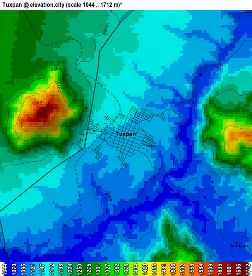
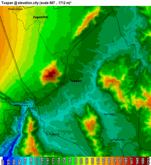
Below is the Elevation map of Tuxpan, which displays elevation range with different colors. Scale of the first map is from 1044 to 1712 m (3425 to 5617 ft) with average elevation of 1175.8 meters (=3858 ft) [note 1]
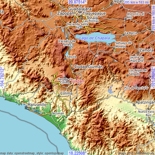
These maps also provides idea of topography and contour of this city, they are displayed at different zoom levels. More info about maps, scale and edge coordinates you can find below images.
| \ | Map #1 | Map #2 | Topo.Map |
| Scale [m] | 1044..1712 m | 887..1712 m | × |
| Scale [ft] | 3425..5617 ft | 2910..5617 ft | × |
| Average | 1175.8 m = 3858 ft | 1208.1 m = 3964 ft | × |
| Width | 9.21 km = 5.7 mi | 18.42 km = 11.4 mi | 294.7 km = 183.1 mi |
| Height | 9.21 km = 5.7 mi | 18.42 km = 11.4 mi | 294.7 km = 183.1 mi |
| ↑Max Latitude | 19.596955° | 19.63835° | 20.87514° |
| Latitude at center | 19.55555° | 19.55555° | 19.55555° |
| ↓Min Latitude | 19.514134° | 19.472708° | 18.22508° |
| ← Min Longitude | -103.419815° | -103.463761° | -104.78212° |
| Longitude center | -103.37587° | -103.37587° | -103.37587° |
| →Max Longitude | -103.331925° | -103.287979° | -101.96962° |
Nearby cities:
Cities around Tuxpan sort by population:
• Ciudad Guzmán elevation 1535 m
18.9 km,  331°
331°
• Zapotiltic 1318 m
9.1 km, 331°
• Tamazula de Gordiano 1140 m
19 km,  43°
43°
• Tecalitlán 1132 m
11.8 km,  142°
142°
• Vista Hermosa 1177 m
15.9 km,  13°
13°
• San Marcos 1144 m
18.3 km,  228°
228°
• Tonila 1161 m
20 km, 227°
• El Rincón 1250 m
12.7 km,  347°
347°
• Soyatlán de Afuera 1133 m
17.9 km,  32°
32°
• La Higuera 989 m
15.1 km,  193°
193°
• Ciudad Guzmán [CERESO] 1587 m
16.8 km,  309°
309°
• San Vicente 1153 m
16.8 km,  51°
51°
Multilingual:
 En español:
Tuxpan elevación 1142 m.
 En France:
Tuxpan élévation 1142 m.


Sources and notes:
- [note 1] Map square and city borders are not equal. Map elevation data is calculated only from area inside that square.
- [src 1] Elevation data from geonames database provided with same terms of usage.
- [src 2] The elevation map of Tuxpan is generated using elevation data from NASA's 3 arcsec (90m) resolution SRTM data.
- [src 3] Base (background) map © OpenStreetMap contributors tiles are generated by Geofabrik and OpenTopoMap.
Copyright & License:
This Tuxpan Elevation Map is licensed under CC BY-SA. You may reuse any part from this page, if you give a proper credit by linking to this URL:
 More info on terms of use page.