Villa García elevation
Villa García (Zacatecas), Mexico elevation is 2103 meters and Villa García elevation in feet is 6900 ft above sea level [src 1]. Villa García is a seat of a second-order administrative division (feature code) with elevation that is 789 meters (2589 ft) bigger than average city elevation in Mexico.
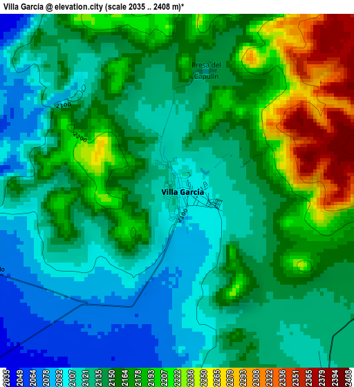
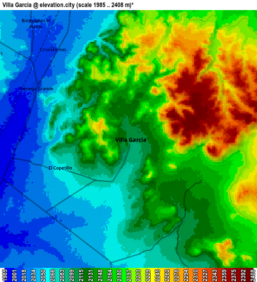
Below is the Elevation map of Villa García, which displays elevation range with different colors. Scale of the first map is from 2035 to 2408 m (6677 to 7900 ft) with average elevation of 2152.2 meters (=7061 ft) [note 1]
These maps also provides idea of topography and contour of this city, they are displayed at different zoom levels. More info about maps, scale and edge coordinates you can find below images.
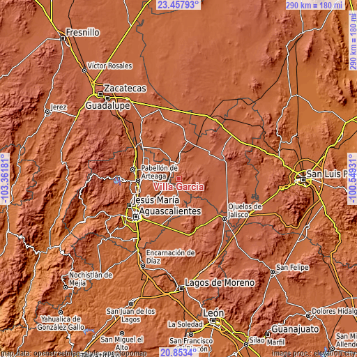
| \ | Map #1 | Map #2 | Topo.Map |
| Scale [m] | 2035..2408 m | 1985..2408 m | × |
| Scale [ft] | 6677..7900 ft | 6512..7900 ft | × |
| Average | 2152.2 m = 7061 ft | 2133.5 m = 7000 ft | × |
| Width | 9.05 km = 5.6 mi | 18.1 km = 11.2 mi | 289.6 km = 179.9 mi |
| Height | 9.05 km = 5.6 mi | 18.1 km = 11.2 mi | 289.6 km = 179.9 mi |
| ↑Max Latitude | 22.202383° | 22.243064° | 23.45793° |
| Latitude at center | 22.16169° | 22.16169° | 22.16169° |
| ↓Min Latitude | 22.120985° | 22.080269° | 20.8534° |
| ← Min Longitude | -101.999505° | -102.043451° | -103.36181° |
| Longitude center | -101.95556° | -101.95556° | -101.95556° |
| →Max Longitude | -101.911615° | -101.867669° | -100.54931° |
Nearby cities:
Cities around Villa García sort by population:
• Loreto elevation 2032 m
12.8 km,  344°
344°
• Villa Juárez 1987 m
13.9 km,  237°
237°
• Ciénega Grande 2012 m
7.5 km,  298°
298°
• San Marcos 2056 m
12.9 km,  1°
1°
• Guadalupe de Atlas 2023 m
14 km,  326°
326°
• Lázaro Cárdenas 2000 m
7.4 km,  278°
278°
• El Copetillo 2064 m
5.1 km,  246°
246°
• Crisóstomos 2027 m
8.6 km, 331°
• Pilotos 2036 m
13.8 km,  181°
181°
• Granadas 2197 m
11.7 km,  125°
125°
• Bimbaletes Aguascalientes (El Álamo) 2018 m
10.4 km,  321°
321°
• Agua Gorda 2102 m
7 km,  150°
150°
Multilingual:
 En español:
Villa García elevación 2103 m.
 En France:
Villa García élévation 2103 m.
 Auf Deutsch:
Villa García höhe über dem Meeresspiegel ist 2103 m.

Sources and notes:
- [note 1] Map square and city borders are not equal. Map elevation data is calculated only from area inside that square.
- [src 1] Elevation data from geonames database provided with same terms of usage.
- [src 2] The elevation map of Villa García is generated using elevation data from NASA's 3 arcsec (90m) resolution SRTM data.
- [src 3] Base (background) map © OpenStreetMap contributors tiles are generated by Geofabrik and OpenTopoMap.
Copyright & License:
This Villa García Elevation Map is licensed under CC BY-SA. You may reuse any part from this page, if you give a proper credit by linking to this URL:
 More info on terms of use page.