López elevation
López (Chihuahua), Mexico elevation is 1425 meters and López elevation in feet is 4675 ft above sea level [src 1]. López is a seat of a second-order administrative division (feature code) with elevation that is 111 meters (364 ft) bigger than average city elevation in Mexico.
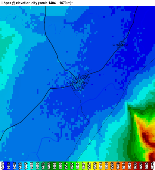
Below is the Elevation map of López, which displays elevation range with different colors. Scale of the first map is from 1404 to 1670 m (4606 to 5479 ft) with average elevation of 1436.6 meters (=4713 ft) [note 1]
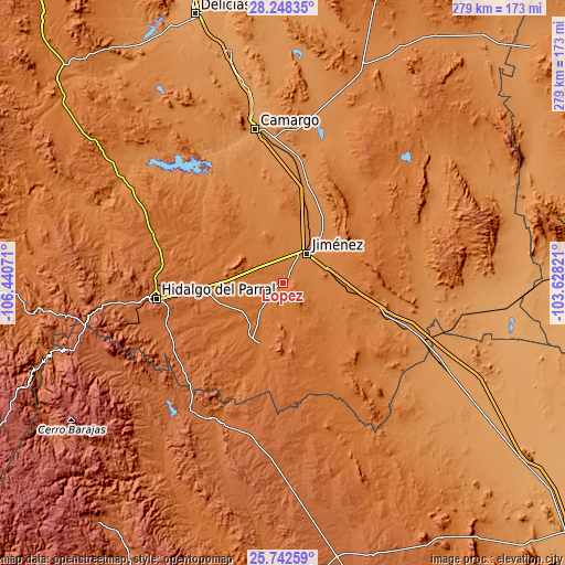
These maps also provides idea of topography and contour of this city, they are displayed at different zoom levels. More info about maps, scale and edge coordinates you can find below images.
| \ | Map #1 | Topo.Map |
| Scale [m] | 1404..1670 m | × |
| Scale [ft] | 4606..5479 ft | × |
| Average | 1436.6 m = 4713 ft | × |
| Width | 8.71 km = 5.4 mi | 278.6 km = 173.1 mi |
| Height | 8.71 km = 5.4 mi | 278.6 km = 173.1 mi |
| ↑Max Latitude | 27.041598° | 28.24835° |
| Latitude at center | 27.00245° | 27.00245° |
| ↓Min Latitude | 26.963288° | 25.74259° |
| ← Min Longitude | -105.078405° | -106.44071° |
| Longitude center | -105.03446° | -105.03446° |
| →Max Longitude | -104.990515° | -103.62821° |
Nearby cities:
Cities around López sort by population:
• Parral elevation 1722 m
63.1 km,  262°
262°
• Camargo 1240 m
76.4 km,  349°
349°
• José Mariano Jiménez 1384 m
18 km,  37°
37°
• Valle de Allende 1604 m
36.3 km, 258°
• Matamoros 1732 m
60.8 km,  243°
243°
• Octaviano López 1425 m
0.1 km,  87°
87°
• Pueblito de Allende 1574 m
29 km,  267°
267°
• Boquilla de Babisas (La Boquilla de Conchos) 1274 m
70.8 km,  329°
329°
• José Esteban Coronado 1514 m
31.9 km,  202°
202°
• Villa Ocampo 1730 m
78.1 km,  216°
216°
• Conchos 1251 m
71.4 km,  335°
335°
• Coronado 1518 m
31.9 km, 202°
Multilingual:
 En español:
Octaviano López elevación 1425 m.
 En France:
López élévation 1425 m.


Sources and notes:
- [note 1] Map square and city borders are not equal. Map elevation data is calculated only from area inside that square.
- [src 1] Elevation data from geonames database provided with same terms of usage.
- [src 2] The elevation map of López is generated using elevation data from NASA's 3 arcsec (90m) resolution SRTM data.
- [src 3] Base (background) map © OpenStreetMap contributors tiles are generated by Geofabrik and OpenTopoMap.
Copyright & License:
This López Elevation Map is licensed under CC BY-SA. You may reuse any part from this page, if you give a proper credit by linking to this URL:
 More info on terms of use page.