Camargo elevation
Camargo (Chihuahua), Mexico elevation is 1240 meters and Camargo elevation in feet is 4068 ft above sea level [src 1]. Camargo is a seat of a second-order administrative division (feature code) with elevation that is 74 meters (243 ft) smaller than average city elevation in Mexico.
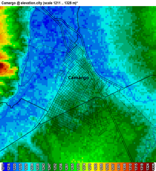
Below is the Elevation map of Camargo, which displays elevation range with different colors. Scale of the first map is from 1211 to 1328 m (3973 to 4357 ft) with average elevation of 1239.2 meters (=4066 ft) [note 1]
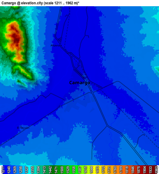
These maps also provides idea of topography and contour of this city, they are displayed at different zoom levels. More info about maps, scale and edge coordinates you can find below images.

| \ | Map #1 | Map #2 | Topo.Map |
| Scale [m] | 1211..1328 m | 1211..1962 m | × |
| Scale [ft] | 3973..4357 ft | 3973..6437 ft | × |
| Average | 1239.2 m = 4066 ft | 1281.3 m = 4204 ft | × |
| Width | 8.65 km = 5.4 mi | 17.31 km = 10.8 mi | 276.9 km = 172.1 mi |
| Height | 8.65 km = 5.4 mi | 17.31 km = 10.8 mi | 276.9 km = 172.1 mi |
| ↑Max Latitude | 27.71733° | 27.756225° | 28.91658° |
| Latitude at center | 27.67842° | 27.67842° | 27.67842° |
| ↓Min Latitude | 27.639496° | 27.600559° | 26.42606° |
| ← Min Longitude | -105.215305° | -105.259251° | -106.57761° |
| Longitude center | -105.17136° | -105.17136° | -105.17136° |
| →Max Longitude | -105.127415° | -105.083469° | -103.76511° |
Nearby cities:
Cities around Camargo sort by population:
• Saucillo elevation 1190 m
41 km,  342°
342°
• Naica 1325 m
37.3 km,  302°
302°
• Miguel Hidalgo 1215 m
57.2 km, 337°
• Las Varas 1173 m
55.7 km, 342°
• Colonia Campesina 1193 m
62.1 km,  325°
325°
• Colonia Nicolás Bravo (Kilómetro Noventa y Dos) 1212 m
57.8 km,  322°
322°
• La Cruz 1207 m
20.7 km,  353°
353°
• Estación Conchos 1217 m
34.7 km, 340°
• Orranteño 1171 m
58.4 km, 343°
• Colonia Abraham González (La Quemada) 1210 m
63.1 km, 338°
• Boquilla de Babisas (La Boquilla de Conchos) 1274 m
27.1 km,  237°
237°
• Conchos 1251 m
18.9 km, 237°
Multilingual:
 En español:
Santa Rosalía de Camargo elevación 1240 m.
 En France:
Camargo élévation 1240 m.
 Auf Deutsch:
Camargo höhe über dem Meeresspiegel ist 1240 m.

Sources and notes:
- [note 1] Map square and city borders are not equal. Map elevation data is calculated only from area inside that square.
- [src 1] Elevation data from geonames database provided with same terms of usage.
- [src 2] The elevation map of Camargo is generated using elevation data from NASA's 3 arcsec (90m) resolution SRTM data.
- [src 3] Base (background) map © OpenStreetMap contributors tiles are generated by Geofabrik and OpenTopoMap.
Copyright & License:
This Camargo Elevation Map is licensed under CC BY-SA. You may reuse any part from this page, if you give a proper credit by linking to this URL:
 More info on terms of use page.