Zirahuén elevation
Zirahuén (Michoacán, Salvador Escalante), Mexico elevation is 2094 meters and Zirahuén elevation in feet is 6870 ft above sea level [src 1]. Zirahuén is a populated place (feature code) with elevation that is 780 meters (2559 ft) bigger than average city elevation in Mexico.
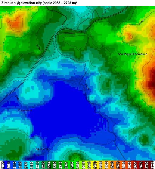
Below is the Elevation map of Zirahuén, which displays elevation range with different colors. Scale of the first map is from 2058 to 2728 m (6752 to 8950 ft) with average elevation of 2232.7 meters (=7325 ft) [note 1]
These maps also provides idea of topography and contour of this city, they are displayed at different zoom levels. More info about maps, scale and edge coordinates you can find below images.
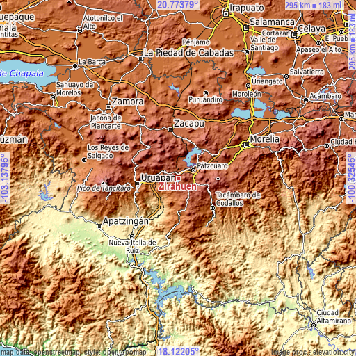
| \ | Map #1 | Topo.Map |
| Scale [m] | 2058..2728 m | × |
| Scale [ft] | 6752..8950 ft | × |
| Average | 2232.7 m = 7325 ft | × |
| Width | 9.21 km = 5.7 mi | 294.8 km = 183.2 mi |
| Height | 9.21 km = 5.7 mi | 294.9 km = 183.2 mi |
| ↑Max Latitude | 19.494771° | 20.77379° |
| Latitude at center | 19.45334° | 19.45334° |
| ↓Min Latitude | 19.411898° | 18.12205° |
| ← Min Longitude | -101.775645° | -103.13795° |
| Longitude center | -101.7317° | -101.7317° |
| →Max Longitude | -101.687755° | -100.32545° |
Nearby cities:
Cities around Zirahuén sort by population:
• Pátzcuaro elevation 2153 m
14.6 km,  61°
61°
• Santa Clara del Cobre 2232 m
11 km,  118°
118°
• Opopeo 2249 m
14.1 km,  109°
109°
• Tingambato 1978 m
13.8 km,  292°
292°
• Jarácuaro 2069 m
13.2 km,  25°
25°
• Santa María Huiramangaro (San Juan Tumbio) 2259 m
7.5 km,  332°
332°
• Uricho 2057 m
13.2 km,  7°
7°
• Ajuno 2101 m
6.7 km, 8°
• Istaro 1876 m
14.1 km,  189°
189°
• Parahuén 2253 m
12 km,  159°
159°
• Chapa 2308 m
10.7 km,  139°
139°
• Santa Ana Chapitiro 2063 m
11.6 km,  45°
45°
Multilingual:
 En español:
Zirahuén elevación 2094 m.
 En France:
Zirahuén élévation 2094 m.
 Auf Deutsch:
Zirahuén höhe über dem Meeresspiegel ist 2094 m.

Sources and notes:
- [note 1] Map square and city borders are not equal. Map elevation data is calculated only from area inside that square.
- [src 1] Elevation data from geonames database provided with same terms of usage.
- [src 2] The elevation map of Zirahuén is generated using elevation data from NASA's 3 arcsec (90m) resolution SRTM data.
- [src 3] Base (background) map © OpenStreetMap contributors tiles are generated by Geofabrik and OpenTopoMap.
Copyright & License:
This Zirahuén Elevation Map is licensed under CC BY-SA. You may reuse any part from this page, if you give a proper credit by linking to this URL:
 More info on terms of use page.