Zirándaro de los Chávez elevation
Zirándaro de los Chávez (Guerrero, Zirándaro), Mexico elevation is 209 meters and Zirándaro de los Chávez elevation in feet is 686 ft above sea level [src 1]. Zirándaro de los Chávez is a seat of a second-order administrative division (feature code) with elevation that is 1105 meters (3625 ft) smaller than average city elevation in Mexico.
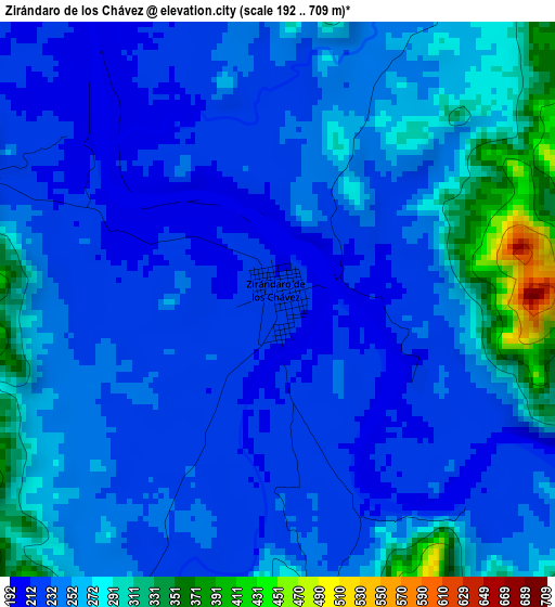
Below is the Elevation map of Zirándaro de los Chávez, which displays elevation range with different colors. Scale of the first map is from 192 to 709 m (630 to 2326 ft) with average elevation of 248.9 meters (=817 ft) [note 1]
These maps also provides idea of topography and contour of this city, they are displayed at different zoom levels. More info about maps, scale and edge coordinates you can find below images.
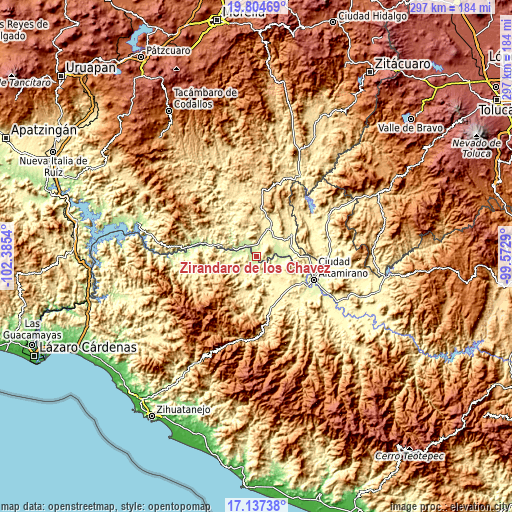
| \ | Map #1 | Topo.Map |
| Scale [m] | 192..709 m | × |
| Scale [ft] | 630..2326 ft | × |
| Average | 248.9 m = 817 ft | × |
| Width | 9.27 km = 5.8 mi | 296.6 km = 184.3 mi |
| Height | 9.27 km = 5.8 mi | 296.6 km = 184.3 mi |
| ↑Max Latitude | 18.517895° | 19.80469° |
| Latitude at center | 18.47622° | 18.47622° |
| ↓Min Latitude | 18.434535° | 17.13738° |
| ← Min Longitude | -101.023095° | -102.3854° |
| Longitude center | -100.97915° | -100.97915° |
| →Max Longitude | -100.935205° | -99.5729° |
Nearby cities:
Cities around Zirándaro de los Chávez sort by population:
• Ciudad Altamirano elevation 250 m
35.2 km,  111°
111°
• Huetamo de Núñez 304 m
19.1 km,  26°
26°
• Coyuca de Catalán 256 m
33.9 km,  119°
119°
• San Lucas 311 m
24.1 km,  58°
58°
• Paso de Arena 348 m
23.8 km,  143°
143°
• Purechucho 284 m
15.2 km,  39°
39°
• Guayameo 642 m
35.4 km,  237°
237°
• Placeres del Oro 383 m
27.9 km,  163°
163°
• Querendas 262 m
39.3 km, 112°
• Santa Teresa 357 m
22.4 km,  131°
131°
• Salguero 275 m
37.9 km,  100°
100°
• Patambó 412 m
30.2 km, 158°
Multilingual:
 En español:
Zirándaro de los Chávez elevación 209 m.
 En France:
Zirándaro de los Chávez élévation 209 m.
 Auf Deutsch:
Zirándaro de los Chávez höhe über dem Meeresspiegel ist 209 m.
 На русском:
Zirándaro de los Chávez высота над уровнем моря 209 м
Sources and notes:
- [note 1] Map square and city borders are not equal. Map elevation data is calculated only from area inside that square.
- [src 1] Elevation data from geonames database provided with same terms of usage.
- [src 2] The elevation map of Zirándaro de los Chávez is generated using elevation data from NASA's 3 arcsec (90m) resolution SRTM data.
- [src 3] Base (background) map © OpenStreetMap contributors tiles are generated by Geofabrik and OpenTopoMap.
Copyright & License:
This Zirándaro de los Chávez Elevation Map is licensed under CC BY-SA. You may reuse any part from this page, if you give a proper credit by linking to this URL:
 More info on terms of use page.