Ejido Benito Juárez elevation
Ejido Benito Juárez (Chihuahua, Buenaventura), Mexico elevation is 1334 meters and Ejido Benito Juárez elevation in feet is 4377 ft above sea level [src 1]. Ejido Benito Juárez is a populated place (feature code) with elevation that is 20 meters (66 ft) bigger than average city elevation in Mexico.
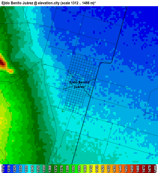
Below is the Elevation map of Ejido Benito Juárez, which displays elevation range with different colors. Scale of the first map is from 1312 to 1486 m (4304 to 4875 ft) with average elevation of 1343.7 meters (=4408 ft) [note 1]
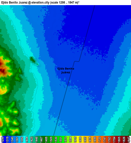
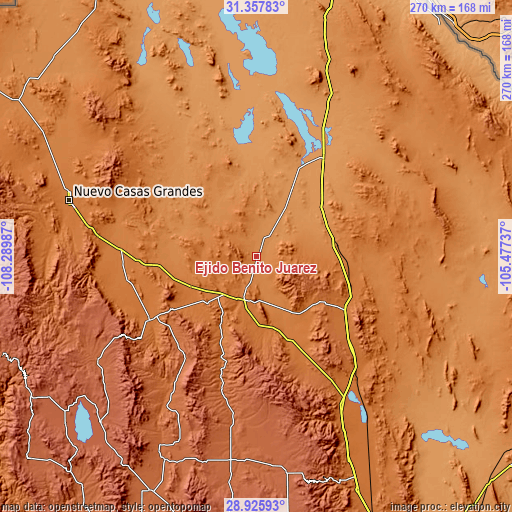
These maps also provides idea of topography and contour of this city, they are displayed at different zoom levels. More info about maps, scale and edge coordinates you can find below images.
| \ | Map #1 | Map #2 | Topo.Map |
| Scale [m] | 1312..1486 m | 1298..1847 m | × |
| Scale [ft] | 4304..4875 ft | 4259..6060 ft | × |
| Average | 1343.7 m = 4408 ft | 1372.4 m = 4503 ft | × |
| Width | 8.45 km = 5.3 mi | 16.9 km = 10.5 mi | 270.4 km = 168 mi |
| Height | 8.45 km = 5.3 mi | 16.9 km = 10.5 mi | 270.4 km = 168 mi |
| ↑Max Latitude | 30.187363° | 30.225341° | 31.35783° |
| Latitude at center | 30.14937° | 30.14937° | 30.14937° |
| ↓Min Latitude | 30.111362° | 30.07334° | 28.92593° |
| ← Min Longitude | -106.927565° | -106.971511° | -108.28987° |
| Longitude center | -106.88362° | -106.88362° | -106.88362° |
| →Max Longitude | -106.839675° | -106.795729° | -105.47737° |
Nearby cities:
Cities around Ejido Benito Juárez sort by population:
• Nuevo Casas Grandes elevation 1455 m
103.1 km,  286°
286°
• Miguel Ahumada 1197 m
63.2 km,  34°
34°
• San Buenaventura 1564 m
65.2 km,  238°
238°
• Benito Juárez 1959 m
111.2 km,  246°
246°
• Casas Grandes 1476 m
106.2 km,  284°
284°
• Ignacio Zaragoza 2013 m
101.9 km, 236°
• La Constitución 1387 m
26.8 km,  161°
161°
• Abdenago C. García 1478 m
66.7 km, 254°
• Benito Juárez 1936 m
109.5 km,  183°
183°
• Rodrígo M. Quevedo 1506 m
66.4 km, 247°
• Las Cruces 1751 m
93.4 km,  211°
211°
• Galeana 1430 m
70.6 km,  266°
266°
Multilingual:
 En español:
Ejido Benito Juárez elevación 1334 m.
 En France:
Ejido Benito Juárez élévation 1334 m.
 Auf Deutsch:
Ejido Benito Juárez höhe über dem Meeresspiegel ist 1334 m.
 На русском:
Ejido Benito Juárez высота над уровнем моря 1334 м
Sources and notes:
- [note 1] Map square and city borders are not equal. Map elevation data is calculated only from area inside that square.
- [src 1] Elevation data from geonames database provided with same terms of usage.
- [src 2] The elevation map of Ejido Benito Juárez is generated using elevation data from NASA's 3 arcsec (90m) resolution SRTM data.
- [src 3] Base (background) map © OpenStreetMap contributors tiles are generated by Geofabrik and OpenTopoMap.
Copyright & License:
This Ejido Benito Juárez Elevation Map is licensed under CC BY-SA. You may reuse any part from this page, if you give a proper credit by linking to this URL:
 More info on terms of use page.