Praxédis Guerrero elevation
Praxédis Guerrero (Chihuahua, Praxedis G. Guerrero), Mexico elevation is 1082 meters and Praxédis Guerrero elevation in feet is 3550 ft above sea level [src 1]. Praxédis Guerrero is a populated place (feature code) with elevation that is 232 meters (761 ft) smaller than average city elevation in Mexico.
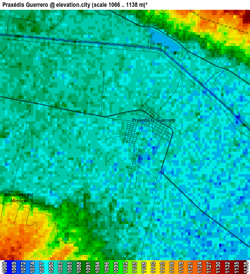
Below is the Elevation map of Praxédis Guerrero, which displays elevation range with different colors. Scale of the first map is from 1066 to 1138 m (3497 to 3734 ft) with average elevation of 1084.6 meters (=3558 ft) [note 1]
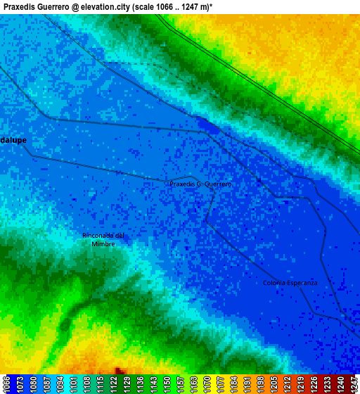
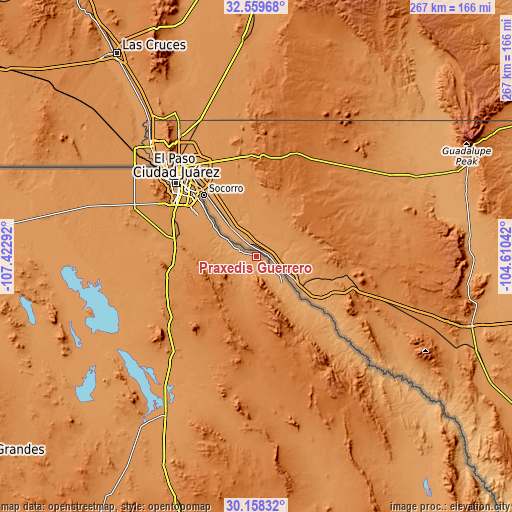
These maps also provides idea of topography and contour of this city, they are displayed at different zoom levels. More info about maps, scale and edge coordinates you can find below images.
| \ | Map #1 | Map #2 | Topo.Map |
| Scale [m] | 1066..1138 m | 1066..1247 m | × |
| Scale [ft] | 3497..3734 ft | 3497..4091 ft | × |
| Average | 1084.6 m = 3558 ft | 1107.8 m = 3635 ft | × |
| Width | 8.34 km = 5.2 mi | 16.69 km = 10.4 mi | 267 km = 165.9 mi |
| Height | 8.34 km = 5.2 mi | 16.69 km = 10.4 mi | 267 km = 165.9 mi |
| ↑Max Latitude | 31.404185° | 31.441686° | 32.55968° |
| Latitude at center | 31.36667° | 31.36667° | 31.36667° |
| ↓Min Latitude | 31.32914° | 31.291594° | 30.15832° |
| ← Min Longitude | -106.060615° | -106.104561° | -107.42292° |
| Longitude center | -106.01667° | -106.01667° | -106.01667° |
| →Max Longitude | -105.972725° | -105.928779° | -104.61042° |
Nearby cities:
Cities around Praxédis Guerrero sort by population:
• Juárez elevation 1124 m
57.6 km,  313°
313°
• Miguel Ahumada 1197 m
95.7 km,  209°
209°
• Ejido Benito Juárez 1334 m
158.7 km, 211°
• Puerto Palomas 1221 m
159.9 km,  286°
286°
• San Isidro 1115 m
31.9 km, 308°
• Guadalupe 1085 m
8.8 km, 286°
• Loma Blanca 1109 m
35.6 km, 311°
• Praxedis G. Guerrero 1082 m
1.1 km,  66°
66°
• Samalayuca 1265 m
44.1 km,  266°
266°
• Guadalupe Victoria 1230 m
164.4 km,  276°
276°
• San Agustín 1109 m
28.1 km, 306°
• Porvenir 1079 m
19.3 km,  136°
136°
Multilingual:
 En español:
Praxédis Guerrero elevación 1082 m.
 En France:
Praxédis Guerrero élévation 1082 m.
 Auf Deutsch:
Praxédis Guerrero höhe über dem Meeresspiegel ist 1082 m.
 На русском:
Praxédis Guerrero высота над уровнем моря 1082 м
Sources and notes:
- [note 1] Map square and city borders are not equal. Map elevation data is calculated only from area inside that square.
- [src 1] Elevation data from geonames database provided with same terms of usage.
- [src 2] The elevation map of Praxédis Guerrero is generated using elevation data from NASA's 3 arcsec (90m) resolution SRTM data.
- [src 3] Base (background) map © OpenStreetMap contributors tiles are generated by Geofabrik and OpenTopoMap.
Copyright & License:
This Praxédis Guerrero Elevation Map is licensed under CC BY-SA. You may reuse any part from this page, if you give a proper credit by linking to this URL:
 More info on terms of use page.