Huilango elevation
Huilango (State of Mexico, Cuautitlán Izcalli), Mexico elevation is 2312 meters and Huilango elevation in feet is 7585 ft above sea level [src 1]. Huilango is a populated place (feature code) with elevation that is 998 meters (3274 ft) bigger than average city elevation in Mexico.
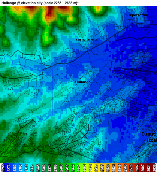
Below is the Elevation map of Huilango, which displays elevation range with different colors. Scale of the first map is from 2258 to 2636 m (7408 to 8648 ft) with average elevation of 2322.3 meters (=7619 ft) [note 1]
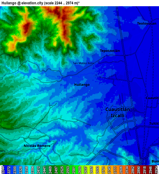
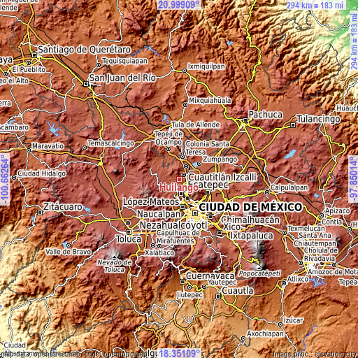
These maps also provides idea of topography and contour of this city, they are displayed at different zoom levels. More info about maps, scale and edge coordinates you can find below images.
| \ | Map #1 | Map #2 | Topo.Map |
| Scale [m] | 2258..2636 m | 2244..2974 m | × |
| Scale [ft] | 7408..8648 ft | 7362..9757 ft | × |
| Average | 2322.3 m = 7619 ft | 2366.8 m = 7765 ft | × |
| Width | 9.2 km = 5.7 mi | 18.4 km = 11.4 mi | 294.4 km = 182.9 mi |
| Height | 9.2 km = 5.7 mi | 18.4 km = 11.4 mi | 294.4 km = 182.9 mi |
| ↑Max Latitude | 19.721933° | 19.763295° | 20.99909° |
| Latitude at center | 19.68056° | 19.68056° | 19.68056° |
| ↓Min Latitude | 19.639176° | 19.597782° | 18.35109° |
| ← Min Longitude | -99.300335° | -99.344281° | -100.66264° |
| Longitude center | -99.25639° | -99.25639° | -99.25639° |
| →Max Longitude | -99.212445° | -99.168499° | -97.85014° |
Nearby cities:
Cities around Huilango sort by population:
• Cuautitlán Izcalli elevation 2288 m
5.9 km,  133°
133°
• Nicolás Romero 2404 m
6.8 km,  230°
230°
• Tepotzotlán 2317 m
5.7 km,  36°
36°
• Santiago Cuautlalpan 2352 m
3.4 km,  276°
276°
• San Mateo Xoloc 2293 m
3 km,  16°
16°
• Axotlán 2274 m
2.3 km,  49°
49°
• Santa Cruz 2305 m
1.8 km,  344°
344°
• San José del Puente 2261 m
7.7 km, 54°
• La Concepción 2331 m
4.9 km,  290°
290°
• San Pablo de los Gallos 2282 m
1.1 km,  109°
109°
• Ejido de Guadalupe 2360 m
5 km,  198°
198°
• Colonia Guadalupe 2310 m
3.7 km,  10°
10°
Multilingual:
 En español:
Huilango elevación 2312 m.
 En France:
Huilango élévation 2312 m.
 Auf Deutsch:
Huilango höhe über dem Meeresspiegel ist 2312 m.

Sources and notes:
- [note 1] Map square and city borders are not equal. Map elevation data is calculated only from area inside that square.
- [src 1] Elevation data from geonames database provided with same terms of usage.
- [src 2] The elevation map of Huilango is generated using elevation data from NASA's 3 arcsec (90m) resolution SRTM data.
- [src 3] Base (background) map © OpenStreetMap contributors tiles are generated by Geofabrik and OpenTopoMap.
Copyright & License:
This Huilango Elevation Map is licensed under CC BY-SA. You may reuse any part from this page, if you give a proper credit by linking to this URL:
 More info on terms of use page.