San Bartolo elevation
San Bartolo (State of Mexico, Teoloyucan), Mexico elevation is 2252 meters and San Bartolo elevation in feet is 7388 ft above sea level [src 1]. San Bartolo is a populated place (feature code) with elevation that is 938 meters (3077 ft) bigger than average city elevation in Mexico.
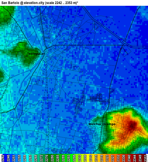
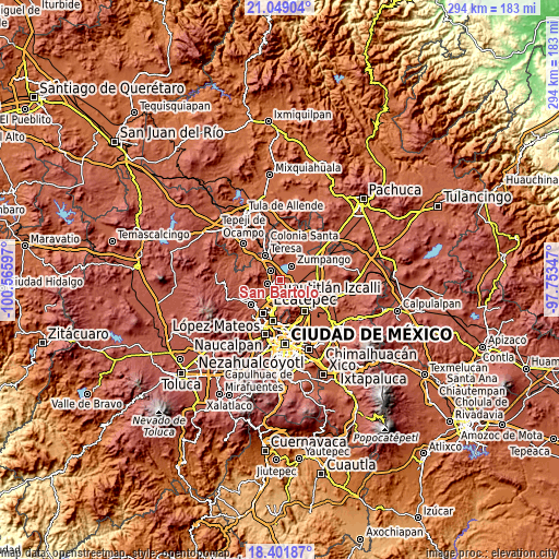
Below is the Elevation map of San Bartolo, which displays elevation range with different colors. Scale of the first map is from 2242 to 2353 m (7356 to 7720 ft) with average elevation of 2257.7 meters (=7407 ft) [note 1]
These maps also provides idea of topography and contour of this city, they are displayed at different zoom levels. More info about maps, scale and edge coordinates you can find below images.

| \ | Map #1 | Map #2 | Topo.Map |
| Scale [m] | 2242..2353 m | 2233..2594 m | × |
| Scale [ft] | 7356..7720 ft | 7326..8510 ft | × |
| Average | 2257.7 m = 7407 ft | 2265.7 m = 7433 ft | × |
| Width | 9.2 km = 5.7 mi | 18.4 km = 11.4 mi | 294.3 km = 182.9 mi |
| Height | 9.2 km = 5.7 mi | 18.4 km = 11.4 mi | 294.4 km = 182.9 mi |
| ↑Max Latitude | 19.7723° | 19.813649° | 21.04904° |
| Latitude at center | 19.73094° | 19.73094° | 19.73094° |
| ↓Min Latitude | 19.689569° | 19.648188° | 18.40187° |
| ← Min Longitude | -99.203665° | -99.247611° | -100.56597° |
| Longitude center | -99.15972° | -99.15972° | -99.15972° |
| →Max Longitude | -99.115775° | -99.071829° | -97.75347° |
Nearby cities:
Cities around San Bartolo sort by population:
• Teoloyucan elevation 2268 m
2.7 km,  303°
303°
• Melchor Ocampo 2262 m
3.6 km,  154°
154°
• San Mateo Ixtacalco 2255 m
3.7 km,  199°
199°
• La Providencia 2250 m
3.3 km,  24°
24°
• Colonia 2 de Septiembre 2309 m
5.6 km,  126°
126°
• San Francisco Tenopalco 2254 m
5 km,  114°
114°
• Santa María Huecatitla 2255 m
1.2 km,  236°
236°
• Barrio Tlatenco 2264 m
3.5 km,  285°
285°
• Lomas de Tenopalco 2299 m
5.9 km,  122°
122°
• San José del Puente 2261 m
4 km,  253°
253°
• Fracción San Roque (El Prieto) 2254 m
5 km, 195°
• La Trinidad 2255 m
5.8 km,  193°
193°
Multilingual:
 En español:
San Bartolo elevación 2252 m.
 En France:
San Bartolo élévation 2252 m.
 Auf Deutsch:
San Bartolo höhe über dem Meeresspiegel ist 2252 m.

Sources and notes:
- [note 1] Map square and city borders are not equal. Map elevation data is calculated only from area inside that square.
- [src 1] Elevation data from geonames database provided with same terms of usage.
- [src 2] The elevation map of San Bartolo is generated using elevation data from NASA's 3 arcsec (90m) resolution SRTM data.
- [src 3] Base (background) map © OpenStreetMap contributors tiles are generated by Geofabrik and OpenTopoMap.
Copyright & License:
This San Bartolo Elevation Map is licensed under CC BY-SA. You may reuse any part from this page, if you give a proper credit by linking to this URL:
 More info on terms of use page.