Tlacomulco elevation
Tlacomulco (State of Mexico, Tianguistenco), Mexico elevation is 2720 meters and Tlacomulco elevation in feet is 8924 ft above sea level [src 1]. Tlacomulco is a populated place (feature code) with elevation that is 1406 meters (4613 ft) bigger than average city elevation in Mexico.
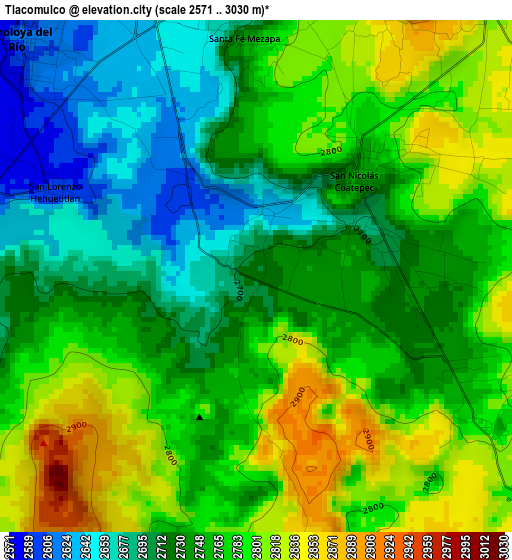
Below is the Elevation map of Tlacomulco, which displays elevation range with different colors. Scale of the first map is from 2571 to 3030 m (8435 to 9941 ft) with average elevation of 2754.8 meters (=9038 ft) [note 1]
These maps also provides idea of topography and contour of this city, they are displayed at different zoom levels. More info about maps, scale and edge coordinates you can find below images.
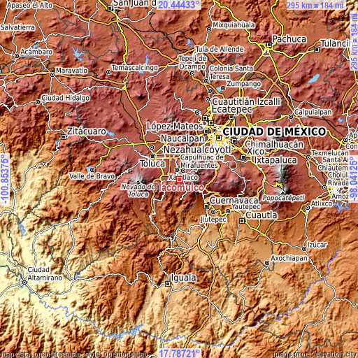
| \ | Map #1 | Topo.Map |
| Scale [m] | 2571..3030 m | × |
| Scale [ft] | 8435..9941 ft | × |
| Average | 2754.8 m = 9038 ft | × |
| Width | 9.23 km = 5.7 mi | 295.4 km = 183.6 mi |
| Height | 9.23 km = 5.7 mi | 295.5 km = 183.6 mi |
| ↑Max Latitude | 19.162626° | 20.44433° |
| Latitude at center | 19.12111° | 19.12111° |
| ↓Min Latitude | 19.079584° | 17.78721° |
| ← Min Longitude | -99.491445° | -100.85375° |
| Longitude center | -99.4475° | -99.4475° |
| →Max Longitude | -99.403555° | -98.04125° |
Nearby cities:
Cities around Tlacomulco sort by population:
• Almoloya del Río elevation 2604 m
6.1 km,  316°
316°
• San Nicolás Coatepec 2756 m
2.6 km,  46°
46°
• Texcalyacac 2590 m
5.8 km,  282°
282°
• San Mateo Texcalyacac 2633 m
5.5 km,  338°
338°
• Tlacuitlapa 2744 m
3.4 km,  88°
88°
• San Lorenzo Huehuetitlán 2599 m
3.9 km,  291°
291°
• Mezapa la Fábrica 2704 m
6.1 km,  2°
2°
• Techichili 2802 m
6.2 km,  25°
25°
• San Bartolo del Progreso 2812 m
5.1 km,  115°
115°
• San José Mezapa Sección I 2673 m
4.7 km,  350°
350°
• Pueblo Nuevo 2779 m
3.1 km, 45°
• Tlaminca 2708 m
1.8 km, 25°
Multilingual:
 En español:
Tlacomulco elevación 2720 m.
 En France:
Tlacomulco élévation 2720 m.
 Auf Deutsch:
Tlacomulco höhe über dem Meeresspiegel ist 2720 m.

Sources and notes:
- [note 1] Map square and city borders are not equal. Map elevation data is calculated only from area inside that square.
- [src 1] Elevation data from geonames database provided with same terms of usage.
- [src 2] The elevation map of Tlacomulco is generated using elevation data from NASA's 3 arcsec (90m) resolution SRTM data.
- [src 3] Base (background) map © OpenStreetMap contributors tiles are generated by Geofabrik and OpenTopoMap.
Copyright & License:
This Tlacomulco Elevation Map is licensed under CC BY-SA. You may reuse any part from this page, if you give a proper credit by linking to this URL:
 More info on terms of use page.