Santa Martha elevation
Santa Martha (Morelos), Mexico elevation is 2826 meters and Santa Martha elevation in feet is 9272 ft above sea level [src 1]. Santa Martha is a populated place (feature code) with elevation that is 1512 meters (4961 ft) bigger than average city elevation in Mexico.
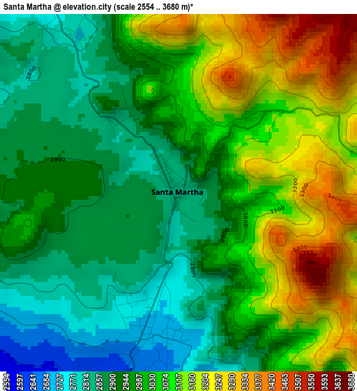
Below is the Elevation map of Santa Martha, which displays elevation range with different colors. Scale of the first map is from 2554 to 3680 m (8379 to 12073 ft) with average elevation of 3003.9 meters (=9855 ft) [note 1]
These maps also provides idea of topography and contour of this city, they are displayed at different zoom levels. More info about maps, scale and edge coordinates you can find below images.
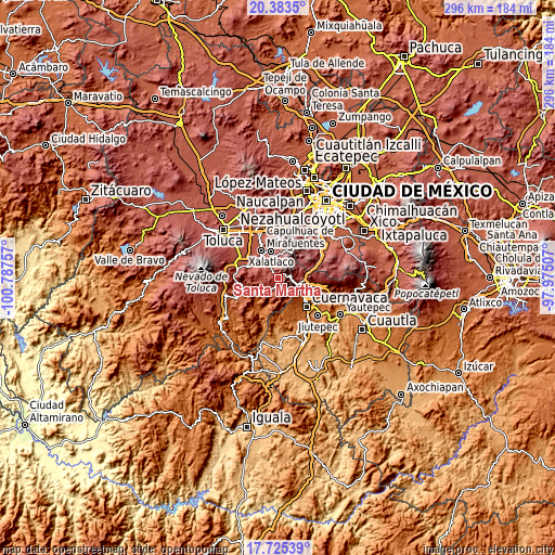
| \ | Map #1 | Topo.Map |
| Scale [m] | 2554..3680 m | × |
| Scale [ft] | 8379..12073 ft | × |
| Average | 3003.9 m = 9855 ft | × |
| Width | 9.24 km = 5.7 mi | 295.6 km = 183.7 mi |
| Height | 9.24 km = 5.7 mi | 295.6 km = 183.7 mi |
| ↑Max Latitude | 19.101301° | 20.3835° |
| Latitude at center | 19.05977° | 19.05977° |
| ↓Min Latitude | 19.018229° | 17.72539° |
| ← Min Longitude | -99.425265° | -100.78757° |
| Longitude center | -99.38132° | -99.38132° |
| →Max Longitude | -99.337375° | -97.97507° |
Nearby cities:
Cities around Santa Martha sort by population:
• San Nicolás Coatepec elevation 2756 m
10 km,  329°
329°
• Santa Mónica 2331 m
8.6 km,  210°
210°
• Tlacuitlapa 2744 m
7.8 km, 332°
• Ocuilan de Arteaga 2353 m
10 km,  203°
203°
• Tlacomulco 2720 m
9.7 km,  314°
314°
• Santa Lucía 2700 m
3.6 km,  189°
189°
• Santa Ana 2377 m
8.7 km, 202°
• El Águila (La Mesa) 2818 m
12.2 km,  347°
347°
• Colonia Doctor Gustavo Baz 2585 m
5.4 km, 197°
• San Bartolo del Progreso 2812 m
5.2 km, 332°
• Pueblo Nuevo 2779 m
10.2 km, 332°
• Tlaminca 2708 m
10.5 km,  323°
323°
Multilingual:
 En español:
Santa Martha elevación 2826 m.
 En France:
Santa Martha élévation 2826 m.
 Auf Deutsch:
Santa Martha höhe über dem Meeresspiegel ist 2826 m.

Sources and notes:
- [note 1] Map square and city borders are not equal. Map elevation data is calculated only from area inside that square.
- [src 1] Elevation data from geonames database provided with same terms of usage.
- [src 2] The elevation map of Santa Martha is generated using elevation data from NASA's 3 arcsec (90m) resolution SRTM data.
- [src 3] Base (background) map © OpenStreetMap contributors tiles are generated by Geofabrik and OpenTopoMap.
Copyright & License:
This Santa Martha Elevation Map is licensed under CC BY-SA. You may reuse any part from this page, if you give a proper credit by linking to this URL:
 More info on terms of use page.