La Esperanza elevation
La Esperanza (State of Mexico, Villa del Carbón), Mexico elevation is 2820 meters and La Esperanza elevation in feet is 9252 ft above sea level [src 1]. La Esperanza is a populated place (feature code) with elevation that is 1506 meters (4941 ft) bigger than average city elevation in Mexico.
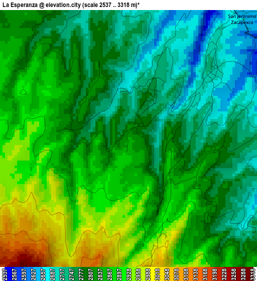
Below is the Elevation map of La Esperanza, which displays elevation range with different colors. Scale of the first map is from 2537 to 3318 m (8323 to 10886 ft) with average elevation of 2825.9 meters (=9271 ft) [note 1]
These maps also provides idea of topography and contour of this city, they are displayed at different zoom levels. More info about maps, scale and edge coordinates you can find below images.
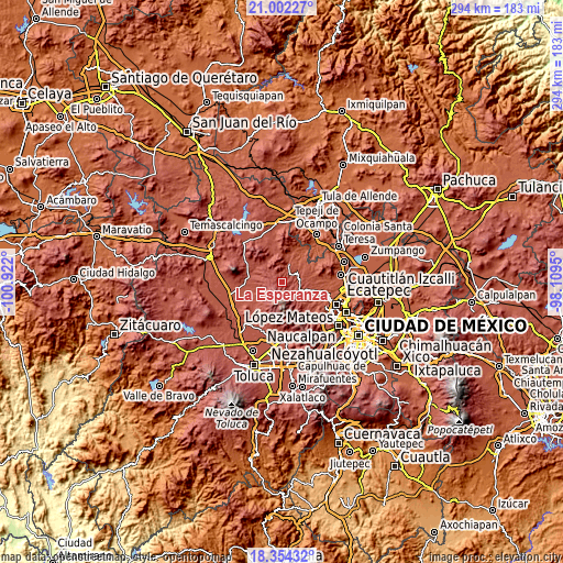
| \ | Map #1 | Topo.Map |
| Scale [m] | 2537..3318 m | × |
| Scale [ft] | 8323..10886 ft | × |
| Average | 2825.9 m = 9271 ft | × |
| Width | 9.2 km = 5.7 mi | 294.4 km = 182.9 mi |
| Height | 9.2 km = 5.7 mi | 294.4 km = 182.9 mi |
| ↑Max Latitude | 19.725142° | 21.00227° |
| Latitude at center | 19.68377° | 19.68377° |
| ↓Min Latitude | 19.642387° | 18.35432° |
| ← Min Longitude | -99.559695° | -100.922° |
| Longitude center | -99.51575° | -99.51575° |
| →Max Longitude | -99.471805° | -98.1095° |
Nearby cities:
Cities around La Esperanza sort by population:
• Villa del Carbón elevation 2600 m
7.4 km,  47°
47°
• Quinto Barrio (Ejido Cahuacán) 2798 m
12.3 km,  123°
123°
• Santa María Magdalena Cahuacán 2741 m
11.9 km, 115°
• Loma Alta 2690 m
7 km,  84°
84°
• Pueblo Nuevo 2787 m
10.7 km,  264°
264°
• Santa Clara de Juárez 2850 m
10.3 km,  292°
292°
• San Lorenzo Malacota 2651 m
10.9 km,  249°
249°
• San Sebastián Buenos Aires 2818 m
10.4 km,  297°
297°
• San Martín Cachihuapan 2603 m
9.2 km,  73°
73°
• Llano de Zacapexco 2689 m
3.9 km, 54°
• Los Arana 2705 m
3.2 km,  26°
26°
• El Ocotal 2674 m
4.8 km,  95°
95°
Multilingual:
 En español:
La Esperanza elevación 2820 m.
 En France:
La Esperanza élévation 2820 m.
 Auf Deutsch:
La Esperanza höhe über dem Meeresspiegel ist 2820 m.

Sources and notes:
- [note 1] Map square and city borders are not equal. Map elevation data is calculated only from area inside that square.
- [src 1] Elevation data from geonames database provided with same terms of usage.
- [src 2] The elevation map of La Esperanza is generated using elevation data from NASA's 3 arcsec (90m) resolution SRTM data.
- [src 3] Base (background) map © OpenStreetMap contributors tiles are generated by Geofabrik and OpenTopoMap.
Copyright & License:
This La Esperanza Elevation Map is licensed under CC BY-SA. You may reuse any part from this page, if you give a proper credit by linking to this URL:
 More info on terms of use page.