Las Huertas elevation
Las Huertas (State of Mexico, Jilotepec), Mexico elevation is 2529 meters and Las Huertas elevation in feet is 8297 ft above sea level [src 1]. Las Huertas is a populated place (feature code) with elevation that is 1215 meters (3986 ft) bigger than average city elevation in Mexico.
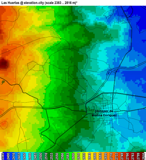
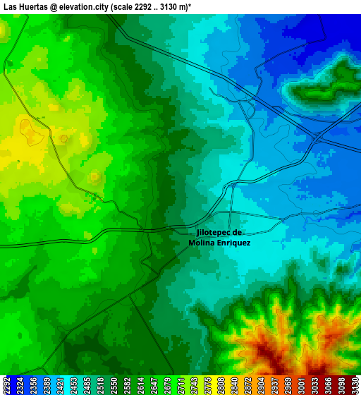
Below is the Elevation map of Las Huertas, which displays elevation range with different colors. Scale of the first map is from 2383 to 2816 m (7818 to 9239 ft) with average elevation of 2545.4 meters (=8351 ft) [note 1]
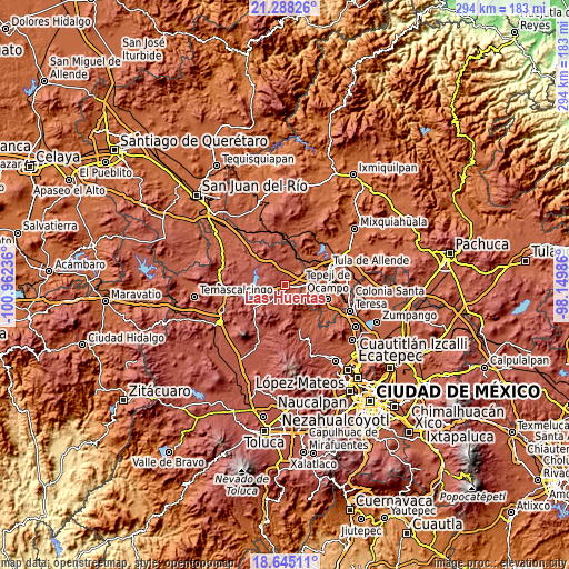
These maps also provides idea of topography and contour of this city, they are displayed at different zoom levels. More info about maps, scale and edge coordinates you can find below images.
| \ | Map #1 | Map #2 | Topo.Map |
| Scale [m] | 2383..2816 m | 2292..3130 m | × |
| Scale [ft] | 7818..9239 ft | 7520..10269 ft | × |
| Average | 2545.4 m = 8351 ft | 2568.6 m = 8427 ft | × |
| Width | 9.18 km = 5.7 mi | 18.37 km = 11.4 mi | 293.9 km = 182.6 mi |
| Height | 9.18 km = 5.7 mi | 18.37 km = 11.4 mi | 293.9 km = 182.6 mi |
| ↑Max Latitude | 20.013517° | 20.054803° | 21.28826° |
| Latitude at center | 19.97222° | 19.97222° | 19.97222° |
| ↓Min Latitude | 19.930912° | 19.889594° | 18.64511° |
| ← Min Longitude | -99.600055° | -99.644001° | -100.96236° |
| Longitude center | -99.55611° | -99.55611° | -99.55611° |
| →Max Longitude | -99.512165° | -99.468219° | -98.14986° |
Nearby cities:
Cities around Las Huertas sort by population:
• Jilotepec de Molina Enríquez elevation 2451 m
3.3 km,  132°
132°
• Soyaniquilpan 2406 m
5.5 km,  29°
29°
• Canalejas 2728 m
5.2 km,  277°
277°
• Las Manzanas 2552 m
2.4 km,  192°
192°
• La Comunidad 2568 m
5.8 km,  338°
338°
• Agua Escondida 2642 m
2.4 km,  287°
287°
• Xhixhata 2491 m
1.1 km,  100°
100°
• Coscomate del Progreso 2479 m
5.7 km,  137°
137°
• Ejido de Coscomate del Progreso 2497 m
4.4 km,  167°
167°
• Xhitey 2435 m
3.1 km,  70°
70°
• Octeyuco Dos Mil 2651 m
3.5 km,  253°
253°
• El Magueyal 2591 m
3.8 km,  210°
210°
Multilingual:
 En español:
Las Huertas elevación 2529 m.
 En France:
Las Huertas élévation 2529 m.
 Auf Deutsch:
Las Huertas höhe über dem Meeresspiegel ist 2529 m.

Sources and notes:
- [note 1] Map square and city borders are not equal. Map elevation data is calculated only from area inside that square.
- [src 1] Elevation data from geonames database provided with same terms of usage.
- [src 2] The elevation map of Las Huertas is generated using elevation data from NASA's 3 arcsec (90m) resolution SRTM data.
- [src 3] Base (background) map © OpenStreetMap contributors tiles are generated by Geofabrik and OpenTopoMap.
Copyright & License:
This Las Huertas Elevation Map is licensed under CC BY-SA. You may reuse any part from this page, if you give a proper credit by linking to this URL:
 More info on terms of use page.