San Pedro del Rosal elevation
San Pedro del Rosal (State of Mexico, Atlacomulco), Mexico elevation is 2570 meters and San Pedro del Rosal elevation in feet is 8432 ft above sea level [src 1]. San Pedro del Rosal is a populated place (feature code) with elevation that is 1256 meters (4121 ft) bigger than average city elevation in Mexico.
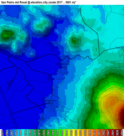
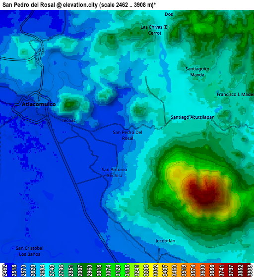
Below is the Elevation map of San Pedro del Rosal, which displays elevation range with different colors. Scale of the first map is from 2517 to 3681 m (8258 to 12077 ft) with average elevation of 2701.5 meters (=8863 ft) [note 1]
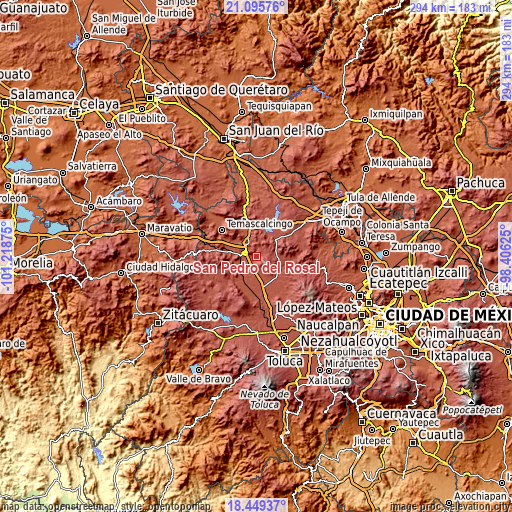
These maps also provides idea of topography and contour of this city, they are displayed at different zoom levels. More info about maps, scale and edge coordinates you can find below images.
| \ | Map #1 | Map #2 | Topo.Map |
| Scale [m] | 2517..3681 m | 2462..3908 m | × |
| Scale [ft] | 8258..12077 ft | 8077..12822 ft | × |
| Average | 2701.5 m = 8863 ft | 2724 m = 8937 ft | × |
| Width | 9.2 km = 5.7 mi | 18.39 km = 11.4 mi | 294.3 km = 182.9 mi |
| Height | 9.2 km = 5.7 mi | 18.39 km = 11.4 mi | 294.3 km = 182.9 mi |
| ↑Max Latitude | 19.819408° | 19.860745° | 21.09576° |
| Latitude at center | 19.77806° | 19.77806° | 19.77806° |
| ↓Min Latitude | 19.736702° | 19.695333° | 18.44937° |
| ← Min Longitude | -99.856445° | -99.900391° | -101.21875° |
| Longitude center | -99.8125° | -99.8125° | -99.8125° |
| →Max Longitude | -99.768555° | -99.724609° | -98.40625° |
Nearby cities:
Cities around San Pedro del Rosal sort by population:
• Atlacomulco de Fabela elevation 2576 m
6.9 km,  289°
289°
• Jocotitlán 2666 m
8 km,  161°
161°
• Santiago Acutzilapan 2757 m
5 km,  79°
79°
• San Antonio Enchisi 2601 m
2.6 km,  189°
189°
• Tecoac (Santa María Nativitas) 2563 m
4.4 km, 286°
• San Francisco Chalchihuapan 2555 m
1.3 km,  226°
226°
• San Felipe Pueblo Nuevo 2944 m
5.8 km,  101°
101°
• Santa María Endare 2700 m
5.8 km,  183°
183°
• El Rincón de la Candelaria 2618 m
3.5 km, 292°
• San José del Tunal 2593 m
3.2 km,  295°
295°
• San Luis Boro 2610 m
6 km,  310°
310°
• San Pablo Atotonilco 2540 m
2.3 km,  331°
331°
Multilingual:
 En español:
San Pedro del Rosal elevación 2570 m.
 En France:
San Pedro del Rosal élévation 2570 m.
 Auf Deutsch:
San Pedro del Rosal höhe über dem Meeresspiegel ist 2570 m.
 На русском:
San Pedro del Rosal высота над уровнем моря 2570 м
Sources and notes:
- [note 1] Map square and city borders are not equal. Map elevation data is calculated only from area inside that square.
- [src 1] Elevation data from geonames database provided with same terms of usage.
- [src 2] The elevation map of San Pedro del Rosal is generated using elevation data from NASA's 3 arcsec (90m) resolution SRTM data.
- [src 3] Base (background) map © OpenStreetMap contributors tiles are generated by Geofabrik and OpenTopoMap.
Copyright & License:
This San Pedro del Rosal Elevation Map is licensed under CC BY-SA. You may reuse any part from this page, if you give a proper credit by linking to this URL:
 More info on terms of use page.