Jocotitlán elevation
Jocotitlán (State of Mexico), Mexico elevation is 2666 meters and Jocotitlán elevation in feet is 8747 ft above sea level [src 1]. Jocotitlán is a seat of a second-order administrative division (feature code) with elevation that is 1352 meters (4436 ft) bigger than average city elevation in Mexico.
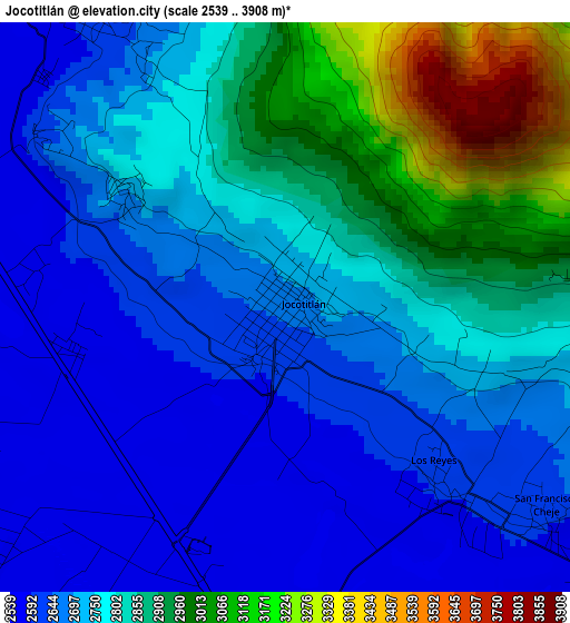
Below is the Elevation map of Jocotitlán, which displays elevation range with different colors. Scale of the first map is from 2539 to 3908 m (8330 to 12822 ft) with average elevation of 2775.9 meters (=9107 ft) [note 1]
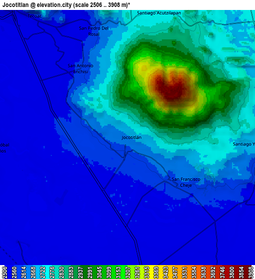
These maps also provides idea of topography and contour of this city, they are displayed at different zoom levels. More info about maps, scale and edge coordinates you can find below images.
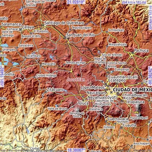
| \ | Map #1 | Map #2 | Topo.Map |
| Scale [m] | 2539..3908 m | 2506..3908 m | × |
| Scale [ft] | 8330..12822 ft | 8222..12822 ft | × |
| Average | 2775.9 m = 9107 ft | 2677 m = 8783 ft | × |
| Width | 9.2 km = 5.7 mi | 18.4 km = 11.4 mi | 294.4 km = 182.9 mi |
| Height | 9.2 km = 5.7 mi | 18.4 km = 11.4 mi | 294.4 km = 182.9 mi |
| ↑Max Latitude | 19.751275° | 19.79263° | 21.02819° |
| Latitude at center | 19.70991° | 19.70991° | 19.70991° |
| ↓Min Latitude | 19.668534° | 19.627147° | 18.38067° |
| ← Min Longitude | -99.832615° | -99.876561° | -101.19492° |
| Longitude center | -99.78867° | -99.78867° | -99.78867° |
| →Max Longitude | -99.744725° | -99.700779° | -98.38242° |
Nearby cities:
Cities around Jocotitlán sort by population:
• San Pedro de los Baños elevation 2554 m
6.7 km,  226°
226°
• San Antonio Enchisi 2601 m
5.8 km,  329°
329°
• Los Reyes 2628 m
3.7 km,  137°
137°
• San Francisco Chalchihuapan 2555 m
7.5 km, 332°
• Santiago Yeché 2716 m
8 km,  91°
91°
• San Francisco Chejé 2622 m
5.3 km,  128°
128°
• San Felipe Pueblo Nuevo 2944 m
7.2 km,  26°
26°
• Santa María Endare 2700 m
3.3 km,  301°
301°
• Mavoro 2574 m
3.6 km,  259°
259°
• Barrio la Tenería 2576 m
1.8 km,  190°
190°
• San José Boqui 2751 m
6.4 km,  98°
98°
• Huemetla 2829 m
5.6 km,  84°
84°
Multilingual:
 En español:
Jocotitlán elevación 2666 m.
 En France:
Jocotitlán élévation 2666 m.
 Auf Deutsch:
Jocotitlán höhe über dem Meeresspiegel ist 2666 m.

Sources and notes:
- [note 1] Map square and city borders are not equal. Map elevation data is calculated only from area inside that square.
- [src 1] Elevation data from geonames database provided with same terms of usage.
- [src 2] The elevation map of Jocotitlán is generated using elevation data from NASA's 3 arcsec (90m) resolution SRTM data.
- [src 3] Base (background) map © OpenStreetMap contributors tiles are generated by Geofabrik and OpenTopoMap.
Copyright & License:
This Jocotitlán Elevation Map is licensed under CC BY-SA. You may reuse any part from this page, if you give a proper credit by linking to this URL:
 More info on terms of use page.