Poblado Cinco elevation
Poblado Cinco (Veracruz, Uxpanapa), Mexico elevation is 110 meters and Poblado Cinco elevation in feet is 361 ft above sea level [src 1]. Poblado Cinco is a populated place (feature code) with elevation that is 1204 meters (3950 ft) smaller than average city elevation in Mexico.
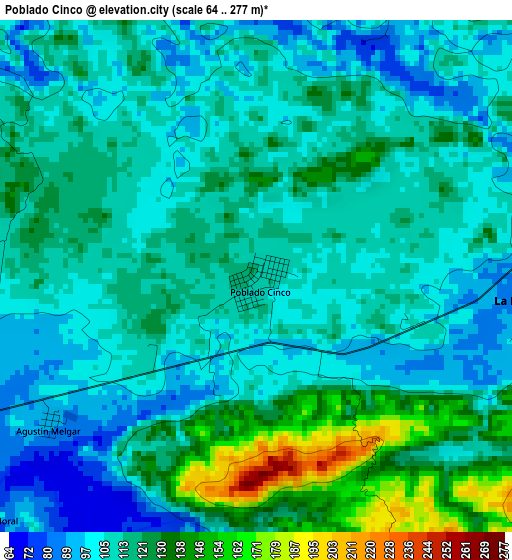
Below is the Elevation map of Poblado Cinco, which displays elevation range with different colors. Scale of the first map is from 64 to 277 m (210 to 909 ft) with average elevation of 113.9 meters (=374 ft) [note 1]
These maps also provides idea of topography and contour of this city, they are displayed at different zoom levels. More info about maps, scale and edge coordinates you can find below images.
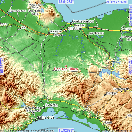
| \ | Map #1 | Topo.Map |
| Scale [m] | 64..277 m | × |
| Scale [ft] | 210..909 ft | × |
| Average | 113.9 m = 374 ft | × |
| Width | 9.33 km = 5.8 mi | 298.6 km = 185.5 mi |
| Height | 9.33 km = 5.8 mi | 298.6 km = 185.5 mi |
| ↑Max Latitude | 17.316488° | 18.61234° |
| Latitude at center | 17.27453° | 17.27453° |
| ↓Min Latitude | 17.232562° | 15.92693° |
| ← Min Longitude | -94.595465° | -95.95777° |
| Longitude center | -94.55152° | -94.55152° |
| →Max Longitude | -94.507575° | -93.14527° |
Nearby cities:
Cities around Poblado Cinco sort by population:
• Poblado 10 elevation 118 m
10.6 km,  88°
88°
• Santa María Chimalapa 313 m
43.3 km,  198°
198°
• Suchilapan del Río 42 m
48 km,  284°
284°
• Donaji 77 m
53.5 km,  264°
264°
• Cuauhtémoc 106 m
40.3 km,  241°
241°
• Helio García Alfaro 63 m
28 km, 93°
• La Horqueta (Poblado Doce) 64 m
37.7 km,  100°
100°
• Hermanos Cedillo 71 m
6.8 km,  248°
248°
• Vicente Guerrero 47 m
30.4 km,  324°
324°
• Venustiano Carranza (Peña Blanca) 15 m
46.2 km,  332°
332°
• Niños Héroes 64 m
18.7 km,  17°
17°
• La Chinantla 113 m
10.8 km, 88°
Multilingual:
 En español:
Poblado Cinco elevación 110 m.
 En France:
Poblado Cinco élévation 110 m.
 Auf Deutsch:
Poblado Cinco höhe über dem Meeresspiegel ist 110 m.

Sources and notes:
- [note 1] Map square and city borders are not equal. Map elevation data is calculated only from area inside that square.
- [src 1] Elevation data from geonames database provided with same terms of usage.
- [src 2] The elevation map of Poblado Cinco is generated using elevation data from NASA's 3 arcsec (90m) resolution SRTM data.
- [src 3] Base (background) map © OpenStreetMap contributors tiles are generated by Geofabrik and OpenTopoMap.
Copyright & License:
This Poblado Cinco Elevation Map is licensed under CC BY-SA. You may reuse any part from this page, if you give a proper credit by linking to this URL:
 More info on terms of use page.