Nuevo Ixcatlán elevation
Nuevo Ixcatlán (Oaxaca), Mexico elevation is 75 meters and Nuevo Ixcatlán elevation in feet is 246 ft above sea level [src 1]. Nuevo Ixcatlán is a populated place (feature code) with elevation that is 1239 meters (4065 ft) smaller than average city elevation in Mexico.
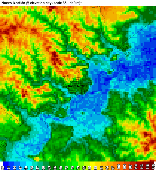
Below is the Elevation map of Nuevo Ixcatlán, which displays elevation range with different colors. Scale of the first map is from 38 to 119 m (125 to 390 ft) with average elevation of 70.6 meters (=232 ft) [note 1]
These maps also provides idea of topography and contour of this city, they are displayed at different zoom levels. More info about maps, scale and edge coordinates you can find below images.
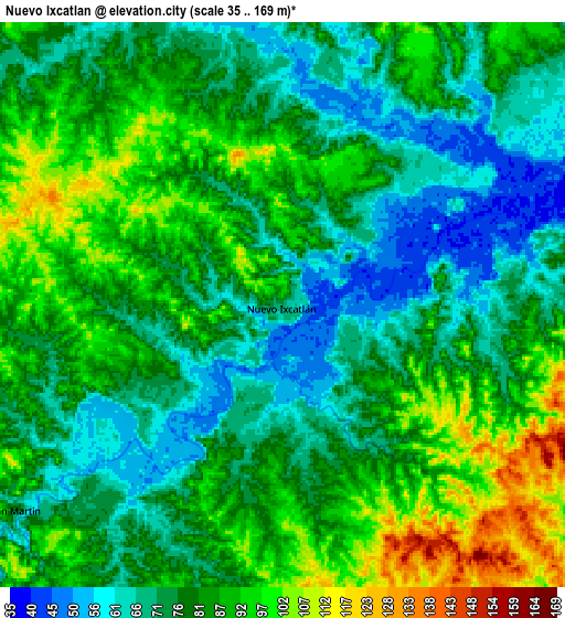
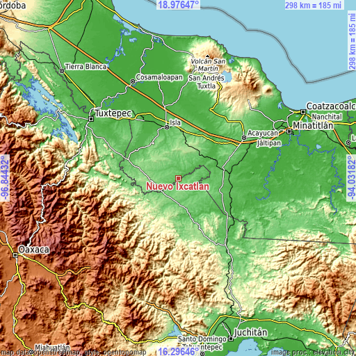
| \ | Map #1 | Map #2 | Topo.Map |
| Scale [m] | 38..119 m | 35..169 m | × |
| Scale [ft] | 125..390 ft | 115..554 ft | × |
| Average | 70.6 m = 232 ft | 80.5 m = 264 ft | × |
| Width | 9.31 km = 5.8 mi | 18.63 km = 11.6 mi | 298 km = 185.2 mi |
| Height | 9.31 km = 5.8 mi | 18.63 km = 11.6 mi | 298 km = 185.2 mi |
| ↑Max Latitude | 17.683324° | 17.725188° | 18.97647° |
| Latitude at center | 17.64145° | 17.64145° | 17.64145° |
| ↓Min Latitude | 17.599566° | 17.557673° | 16.29646° |
| ← Min Longitude | -95.482015° | -95.525961° | -96.84432° |
| Longitude center | -95.43807° | -95.43807° | -95.43807° |
| →Max Longitude | -95.394125° | -95.350179° | -94.03182° |
Nearby cities:
Cities around Nuevo Ixcatlán sort by population:
• María Lombardo de Caso elevation 104 m
21.4 km,  177°
177°
• Estación Juanita 65 m
29.9 km,  51°
51°
• Abasolo del Valle 175 m
19.4 km,  324°
324°
• Los Tigres (San Marcos) 188 m
29.2 km,  18°
18°
• San Felipe Cihualtepec 82 m
19.7 km,  157°
157°
• Jaltepec de Candayoc 70 m
32 km, 175°
• El Porvenir 99 m
26.8 km,  133°
133°
• Tatahuicapá 95 m
23.7 km,  244°
244°
• Nuevo San Martín 74 m
11.3 km,  232°
232°
• Santa Teresa 104 m
25.6 km,  283°
283°
• Boca del Monte 162 m
31.2 km,  264°
264°
• Xochiapa 147 m
31.6 km,  274°
274°
Multilingual:
 En español:
Nuevo Ixcatlán elevación 75 m.
 En France:
Nuevo Ixcatlán élévation 75 m.
 Auf Deutsch:
Nuevo Ixcatlán höhe über dem Meeresspiegel ist 75 m.

Sources and notes:
- [note 1] Map square and city borders are not equal. Map elevation data is calculated only from area inside that square.
- [src 1] Elevation data from geonames database provided with same terms of usage.
- [src 2] The elevation map of Nuevo Ixcatlán is generated using elevation data from NASA's 3 arcsec (90m) resolution SRTM data.
- [src 3] Base (background) map © OpenStreetMap contributors tiles are generated by Geofabrik and OpenTopoMap.
Copyright & License:
This Nuevo Ixcatlán Elevation Map is licensed under CC BY-SA. You may reuse any part from this page, if you give a proper credit by linking to this URL:
 More info on terms of use page.