Palma Sola elevation
Palma Sola (Veracruz, Alto Lucero de Gutiérrez Barrios), Mexico elevation is 14 meters and Palma Sola elevation in feet is 46 ft above sea level [src 1]. Palma Sola is a populated place (feature code) with elevation that is 1300 meters (4265 ft) smaller than average city elevation in Mexico.
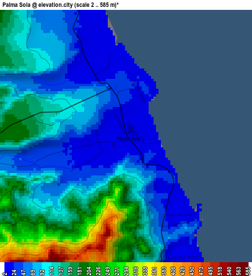
Below is the Elevation map of Palma Sola, which displays elevation range with different colors. Scale of the first map is from 2 to 585 m (7 to 1919 ft) with average elevation of 113.2 meters (=371 ft) [note 1]
These maps also provides idea of topography and contour of this city, they are displayed at different zoom levels. More info about maps, scale and edge coordinates you can find below images.
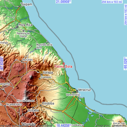
| \ | Map #1 | Topo.Map |
| Scale [m] | 2..585 m | × |
| Scale [ft] | 7..1919 ft | × |
| Average | 113.2 m = 371 ft | × |
| Width | 9.2 km = 5.7 mi | 294.3 km = 182.9 mi |
| Height | 9.2 km = 5.7 mi | 294.3 km = 182.9 mi |
| ↑Max Latitude | 19.812669° | 21.08908° |
| Latitude at center | 19.77132° | 19.77132° |
| ↓Min Latitude | 19.72996° | 18.44258° |
| ← Min Longitude | -96.476195° | -97.8385° |
| Longitude center | -96.43225° | -96.43225° |
| →Max Longitude | -96.388305° | -95.026° |
Nearby cities:
Cities around Palma Sola sort by population:
• Villa Emilio Carranza elevation 65 m
29 km,  319°
319°
• Mozomboa 74 m
30.1 km,  189°
189°
• Juchique de Ferrer 385 m
28.5 km,  285°
285°
• Plan de las Hayas 1057 m
25.5 km,  267°
267°
• Tinajitas 51 m
17.1 km,  183°
183°
• San Isidro 15 m
32.6 km,  170°
170°
• La Reforma 684 m
28.6 km,  227°
227°
• Cerro Gordo 644 m
31.9 km, 225°
• Monte Verde Chivería 1468 m
28.6 km,  254°
254°
• La Sombra 1221 m
29.6 km, 265°
• Palmas de Abajo 68 m
20.2 km, 181°
• Laguna de Farfán 667 m
22.4 km,  279°
279°
Multilingual:
 En español:
Palma Sola elevación 14 m.
 En France:
Palma Sola élévation 14 m.
 Auf Deutsch:
Palma Sola höhe über dem Meeresspiegel ist 14 m.

Sources and notes:
- [note 1] Map square and city borders are not equal. Map elevation data is calculated only from area inside that square.
- [src 1] Elevation data from geonames database provided with same terms of usage.
- [src 2] The elevation map of Palma Sola is generated using elevation data from NASA's 3 arcsec (90m) resolution SRTM data.
- [src 3] Base (background) map © OpenStreetMap contributors tiles are generated by Geofabrik and OpenTopoMap.
Copyright & License:
This Palma Sola Elevation Map is licensed under CC BY-SA. You may reuse any part from this page, if you give a proper credit by linking to this URL:
 More info on terms of use page.