Comején elevation
Comején (Veracruz, Acayucan), Mexico elevation is 85 meters and Comején elevation in feet is 279 ft above sea level [src 1]. Comején is a populated place (feature code) with elevation that is 1229 meters (4032 ft) smaller than average city elevation in Mexico.
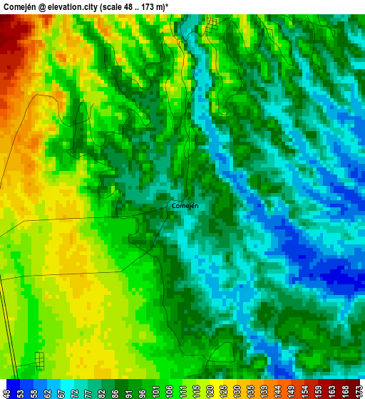
Below is the Elevation map of Comején, which displays elevation range with different colors. Scale of the first map is from 48 to 173 m (157 to 568 ft) with average elevation of 96.1 meters (=315 ft) [note 1]
These maps also provides idea of topography and contour of this city, they are displayed at different zoom levels. More info about maps, scale and edge coordinates you can find below images.
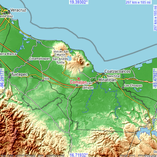
| \ | Map #1 | Topo.Map |
| Scale [m] | 48..173 m | × |
| Scale [ft] | 157..568 ft | × |
| Average | 96.1 m = 315 ft | × |
| Width | 9.29 km = 5.8 mi | 297.3 km = 184.7 mi |
| Height | 9.29 km = 5.8 mi | 297.3 km = 184.7 mi |
| ↑Max Latitude | 18.103035° | 19.39302° |
| Latitude at center | 18.06126° | 18.06126° |
| ↓Min Latitude | 18.019475° | 16.71932° |
| ← Min Longitude | -94.929465° | -96.29177° |
| Longitude center | -94.88552° | -94.88552° |
| →Max Longitude | -94.841575° | -93.47927° |
Nearby cities:
Cities around Comején sort by population:
• Acayucan elevation 102 m
12.8 km,  193°
193°
• Oluta 81 m
14.7 km,  184°
184°
• Soconusco 78 m
10.9 km, 177°
• Colonia Lealtad 104 m
11.1 km, 189°
• Morelos 408 m
14.8 km,  332°
332°
• Huazuntlán 73 m
14.4 km,  42°
42°
• Ixhuapán 84 m
15.7 km, 35°
• Fraccionamiento Santa Cruz 84 m
10 km, 185°
• Quiamoloapan 173 m
11.7 km,  270°
270°
• Ixhuapan 88 m
5.4 km,  170°
170°
• Saltillo 200 m
11.4 km,  17°
17°
• Campo de Águila 185 m
10.7 km, 273°
Multilingual:
 En español:
Comején elevación 85 m.
 En France:
Comején élévation 85 m.


Sources and notes:
- [note 1] Map square and city borders are not equal. Map elevation data is calculated only from area inside that square.
- [src 1] Elevation data from geonames database provided with same terms of usage.
- [src 2] The elevation map of Comején is generated using elevation data from NASA's 3 arcsec (90m) resolution SRTM data.
- [src 3] Base (background) map © OpenStreetMap contributors tiles are generated by Geofabrik and OpenTopoMap.
Copyright & License:
This Comején Elevation Map is licensed under CC BY-SA. You may reuse any part from this page, if you give a proper credit by linking to this URL:
 More info on terms of use page.