Bolonchén de Rejón elevation
Bolonchén de Rejón (Campeche, Hopelchén), Mexico elevation is 131 meters and Bolonchén de Rejón elevation in feet is 430 ft above sea level [src 1]. Bolonchén de Rejón is a populated place (feature code) with elevation that is 1183 meters (3881 ft) smaller than average city elevation in Mexico.
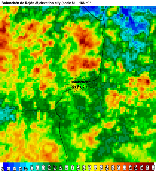
Below is the Elevation map of Bolonchén de Rejón, which displays elevation range with different colors. Scale of the first map is from 81 to 186 m (266 to 610 ft) with average elevation of 131.1 meters (=430 ft) [note 1]
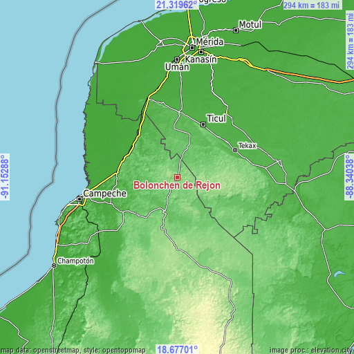
These maps also provides idea of topography and contour of this city, they are displayed at different zoom levels. More info about maps, scale and edge coordinates you can find below images.
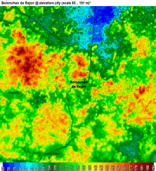
| \ | Map #1 | Map #2 | Topo.Map |
| Scale [m] | 81..186 m | 65..191 m | × |
| Scale [ft] | 266..610 ft | 213..627 ft | × |
| Average | 131.1 m = 430 ft | 126.3 m = 414 ft | × |
| Width | 9.18 km = 5.7 mi | 18.37 km = 11.4 mi | 293.8 km = 182.6 mi |
| Height | 9.18 km = 5.7 mi | 18.37 km = 11.4 mi | 293.9 km = 182.6 mi |
| ↑Max Latitude | 20.045149° | 20.086426° | 21.31962° |
| Latitude at center | 20.00386° | 20.00386° | 20.00386° |
| ↓Min Latitude | 19.962561° | 19.92125° | 18.67701° |
| ← Min Longitude | -89.790575° | -89.834521° | -91.15288° |
| Longitude center | -89.74663° | -89.74663° | -89.74663° |
| →Max Longitude | -89.702685° | -89.658739° | -88.34038° |
Nearby cities:
Cities around Bolonchén de Rejón sort by population:
• Hecelchakán elevation 12 m
44.8 km,  295°
295°
• Hopelchén 88 m
30.4 km,  199°
199°
• Santa Elena 44 m
37.7 km,  16°
16°
• Bacabchén 13 m
45.3 km,  314°
314°
• Yaxhachen 111 m
19.6 km,  74°
74°
• Pocboc 11 m
45.2 km, 304°
• Cumpich 48 m
31 km, 310°
• Xohuayan 115 m
43.1 km,  61°
61°
• Emiliano Zapata 57 m
38.2 km,  49°
49°
• Suc-Tuc 85 m
44.4 km,  223°
223°
• Santa Cruz 9 m
44.6 km, 299°
• Xul 95 m
31.6 km, 69°
Multilingual:
 En español:
Bolonchen elevación 131 m.
 En France:
Bolonchén de Rejón élévation 131 m.
 Auf Deutsch:
Bolonchén de Rejón höhe über dem Meeresspiegel ist 131 m.
 На русском:
Bolonchén de Rejón высота над уровнем моря 131 м
Sources and notes:
- [note 1] Map square and city borders are not equal. Map elevation data is calculated only from area inside that square.
- [src 1] Elevation data from geonames database provided with same terms of usage.
- [src 2] The elevation map of Bolonchén de Rejón is generated using elevation data from NASA's 3 arcsec (90m) resolution SRTM data.
- [src 3] Base (background) map © OpenStreetMap contributors tiles are generated by Geofabrik and OpenTopoMap.
Copyright & License:
This Bolonchén de Rejón Elevation Map is licensed under CC BY-SA. You may reuse any part from this page, if you give a proper credit by linking to this URL:
 More info on terms of use page.