Hopelchén elevation
Hopelchén (Campeche), Mexico elevation is 88 meters and Hopelchén elevation in feet is 289 ft above sea level [src 1]. Hopelchén is a seat of a second-order administrative division (feature code) with elevation that is 1226 meters (4022 ft) smaller than average city elevation in Mexico.
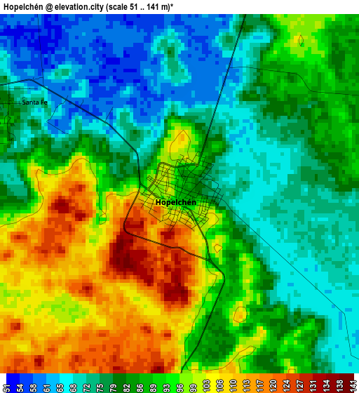
Below is the Elevation map of Hopelchén, which displays elevation range with different colors. Scale of the first map is from 51 to 141 m (167 to 463 ft) with average elevation of 86.4 meters (=283 ft) [note 1]
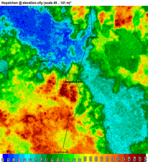
These maps also provides idea of topography and contour of this city, they are displayed at different zoom levels. More info about maps, scale and edge coordinates you can find below images.
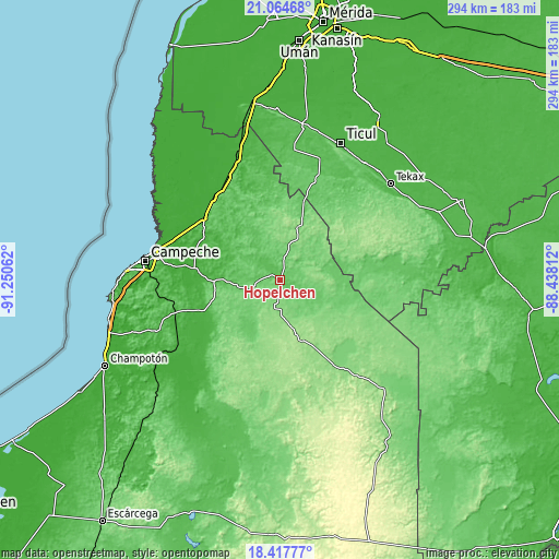
| \ | Map #1 | Map #2 | Topo.Map |
| Scale [m] | 51..141 m | 49..141 m | × |
| Scale [ft] | 167..463 ft | 161..463 ft | × |
| Average | 86.4 m = 283 ft | 88.2 m = 289 ft | × |
| Width | 9.2 km = 5.7 mi | 18.4 km = 11.4 mi | 294.3 km = 182.9 mi |
| Height | 9.2 km = 5.7 mi | 18.4 km = 11.4 mi | 294.3 km = 182.9 mi |
| ↑Max Latitude | 19.788066° | 19.829411° | 21.06468° |
| Latitude at center | 19.74671° | 19.74671° | 19.74671° |
| ↓Min Latitude | 19.705344° | 19.663966° | 18.41777° |
| ← Min Longitude | -89.888315° | -89.932261° | -91.25062° |
| Longitude center | -89.84437° | -89.84437° | -89.84437° |
| →Max Longitude | -89.800425° | -89.756479° | -88.43812° |
Nearby cities:
Cities around Hopelchén sort by population:
• Tenabo elevation 10 m
51.5 km,  309°
309°
• Bolonchén de Rejón 131 m
30.4 km,  19°
19°
• Iturbide 123 m
31.5 km,  126°
126°
• Dzibalchén 162 m
34.2 km,  159°
159°
• Los Laureles 85 m
32.8 km,  208°
208°
• Alfredo V. Bonfil 31 m
42.8 km,  235°
235°
• Pich 117 m
40.8 km,  224°
224°
• Tikinmul 18 m
39.7 km,  273°
273°
• Yaxhachen 111 m
44.7 km,  40°
40°
• Cumpich 48 m
50.6 km,  344°
344°
• Suc-Tuc 85 m
20.6 km,  259°
259°
• Chunchintok 142 m
50.9 km,  147°
147°
Multilingual:
 En español:
Hopelchen elevación 88 m.
 En France:
Hopelchén élévation 88 m.
 Auf Deutsch:
Hopelchén höhe über dem Meeresspiegel ist 88 m.

Sources and notes:
- [note 1] Map square and city borders are not equal. Map elevation data is calculated only from area inside that square.
- [src 1] Elevation data from geonames database provided with same terms of usage.
- [src 2] The elevation map of Hopelchén is generated using elevation data from NASA's 3 arcsec (90m) resolution SRTM data.
- [src 3] Base (background) map © OpenStreetMap contributors tiles are generated by Geofabrik and OpenTopoMap.
Copyright & License:
This Hopelchén Elevation Map is licensed under CC BY-SA. You may reuse any part from this page, if you give a proper credit by linking to this URL:
 More info on terms of use page.