Santa Rosa elevation
Santa Rosa (Puebla, Tecamachalco), Mexico elevation is 2003 meters and Santa Rosa elevation in feet is 6572 ft above sea level [src 1]. Santa Rosa is a populated place (feature code) with elevation that is 689 meters (2260 ft) bigger than average city elevation in Mexico.
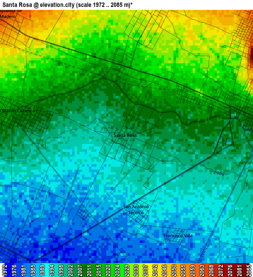
Below is the Elevation map of Santa Rosa, which displays elevation range with different colors. Scale of the first map is from 1972 to 2085 m (6470 to 6841 ft) with average elevation of 2006.8 meters (=6584 ft) [note 1]
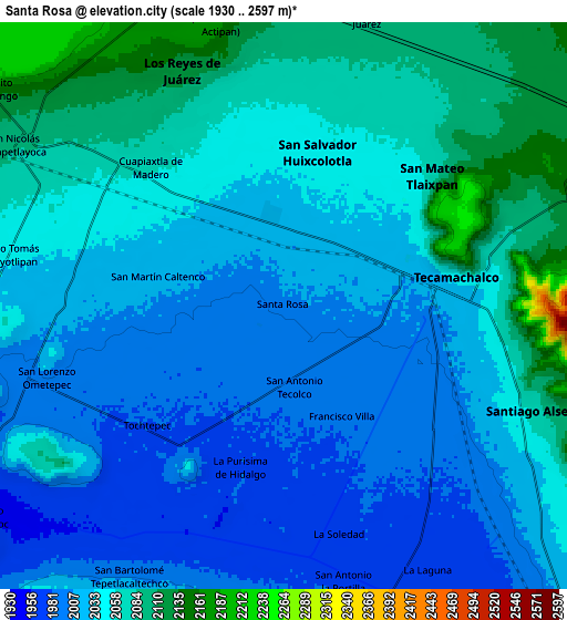
These maps also provides idea of topography and contour of this city, they are displayed at different zoom levels. More info about maps, scale and edge coordinates you can find below images.
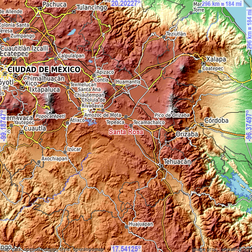
| \ | Map #1 | Map #2 | Topo.Map |
| Scale [m] | 1972..2085 m | 1930..2597 m | × |
| Scale [ft] | 6470..6841 ft | 6332..8520 ft | × |
| Average | 2006.8 m = 6584 ft | 2038.6 m = 6688 ft | × |
| Width | 9.25 km = 5.7 mi | 18.49 km = 11.5 mi | 295.9 km = 183.9 mi |
| Height | 9.25 km = 5.7 mi | 18.49 km = 11.5 mi | 295.9 km = 183.9 mi |
| ↑Max Latitude | 18.918617° | 18.960183° | 20.20227° |
| Latitude at center | 18.87704° | 18.87704° | 18.87704° |
| ↓Min Latitude | 18.835453° | 18.793856° | 17.54125° |
| ← Min Longitude | -97.825165° | -97.869111° | -99.18747° |
| Longitude center | -97.78122° | -97.78122° | -97.78122° |
| →Max Longitude | -97.737275° | -97.693329° | -96.37497° |
Nearby cities:
Cities around Santa Rosa sort by population:
• Tecamachalco elevation 2020 m
5.1 km,  81°
81°
• Huixcolotla 2044 m
5 km,  11°
11°
• Tlaixpan 2058 m
6 km,  49°
49°
• Cuapiaxtla de Madero 2061 m
6.2 km,  313°
313°
• Tochtepec 1980 m
6.1 km,  226°
226°
• San Martín Caltenco 2015 m
4.1 km,  282°
282°
• Zacaola 2020 m
7 km,  273°
273°
• La Purísima 1975 m
5.5 km,  194°
194°
• Xochimilco 2000 m
7 km,  124°
124°
• San Antonio Tecolco 1989 m
2.8 km,  173°
173°
• Lomas de Santa Cruz 2099 m
7.5 km, 45°
• Francisco Villa 1987 m
4.1 km,  152°
152°
Multilingual:
 En español:
Santa Rosa elevación 2003 m.
 En France:
Santa Rosa élévation 2003 m.
 Auf Deutsch:
Santa Rosa höhe über dem Meeresspiegel ist 2003 m.

Sources and notes:
- [note 1] Map square and city borders are not equal. Map elevation data is calculated only from area inside that square.
- [src 1] Elevation data from geonames database provided with same terms of usage.
- [src 2] The elevation map of Santa Rosa is generated using elevation data from NASA's 3 arcsec (90m) resolution SRTM data.
- [src 3] Base (background) map © OpenStreetMap contributors tiles are generated by Geofabrik and OpenTopoMap.
Copyright & License:
This Santa Rosa Elevation Map is licensed under CC BY-SA. You may reuse any part from this page, if you give a proper credit by linking to this URL:
 More info on terms of use page.