Atecax elevation
Atecax (Puebla, Xiutetelco), Mexico elevation is 2774 meters and Atecax elevation in feet is 9101 ft above sea level [src 1]. Atecax is a populated place (feature code) with elevation that is 1460 meters (4790 ft) bigger than average city elevation in Mexico.
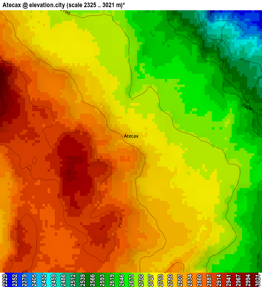
Below is the Elevation map of Atecax, which displays elevation range with different colors. Scale of the first map is from 2325 to 3021 m (7628 to 9911 ft) with average elevation of 2760.6 meters (=9057 ft) [note 1]
These maps also provides idea of topography and contour of this city, they are displayed at different zoom levels. More info about maps, scale and edge coordinates you can find below images.
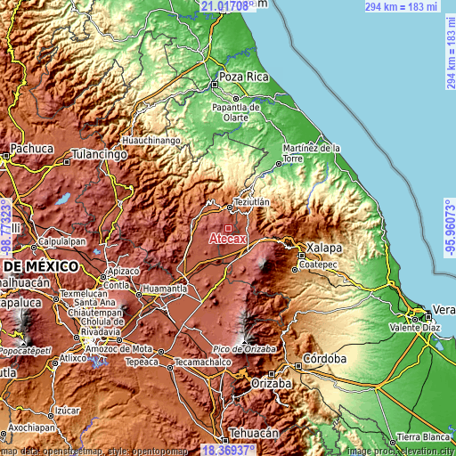
| \ | Map #1 | Topo.Map |
| Scale [m] | 2325..3021 m | × |
| Scale [ft] | 7628..9911 ft | × |
| Average | 2760.6 m = 9057 ft | × |
| Width | 9.2 km = 5.7 mi | 294.4 km = 182.9 mi |
| Height | 9.2 km = 5.7 mi | 294.4 km = 182.9 mi |
| ↑Max Latitude | 19.740068° | 21.01708° |
| Latitude at center | 19.6987° | 19.6987° |
| ↓Min Latitude | 19.657321° | 18.36937° |
| ← Min Longitude | -97.410925° | -98.77323° |
| Longitude center | -97.36698° | -97.36698° |
| →Max Longitude | -97.323035° | -95.96073° |
Nearby cities:
Cities around Atecax sort by population:
• San Francisco elevation 2013 m
9.6 km,  25°
25°
• San Isidro 2108 m
11 km,  350°
350°
• Orilla del Monte 2402 m
8.8 km,  118°
118°
• Mixquiapan 2302 m
9.3 km,  88°
88°
• San Andrés 2033 m
10.6 km,  16°
16°
• San Martín 2050 m
9.7 km, 16°
• San Antonio 2432 m
6.5 km,  9°
9°
• Cuauhtamingo 2047 m
9.2 km,  36°
36°
• Veintiuno de Agosto 2179 m
10.3 km,  73°
73°
• Sección 23 2232 m
10 km, 352°
• Tomaquilapa 2094 m
8 km, 36°
• Miguel Hidalgo 2072 m
11 km,  53°
53°
Multilingual:
 En español:
Atecax elevación 2774 m.
 En France:
Atecax élévation 2774 m.


Sources and notes:
- [note 1] Map square and city borders are not equal. Map elevation data is calculated only from area inside that square.
- [src 1] Elevation data from geonames database provided with same terms of usage.
- [src 2] The elevation map of Atecax is generated using elevation data from NASA's 3 arcsec (90m) resolution SRTM data.
- [src 3] Base (background) map © OpenStreetMap contributors tiles are generated by Geofabrik and OpenTopoMap.
Copyright & License:
This Atecax Elevation Map is licensed under CC BY-SA. You may reuse any part from this page, if you give a proper credit by linking to this URL:
 More info on terms of use page.