Ixtlahuaca de Cuauhtémoc elevation
Ixtlahuaca de Cuauhtémoc (State of Mexico, Temascalapa), Mexico elevation is 2320 meters and Ixtlahuaca de Cuauhtémoc elevation in feet is 7612 ft above sea level [src 1]. Ixtlahuaca de Cuauhtémoc is a populated place (feature code) with elevation that is 1006 meters (3301 ft) bigger than average city elevation in Mexico.
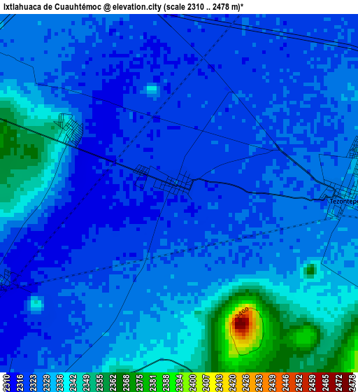
Below is the Elevation map of Ixtlahuaca de Cuauhtémoc, which displays elevation range with different colors. Scale of the first map is from 2310 to 2478 m (7579 to 8130 ft) with average elevation of 2328.4 meters (=7639 ft) [note 1]
These maps also provides idea of topography and contour of this city, they are displayed at different zoom levels. More info about maps, scale and edge coordinates you can find below images.
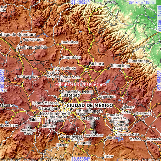
| \ | Map #1 | Topo.Map |
| Scale [m] | 2310..2478 m | × |
| Scale [ft] | 7579..8130 ft | × |
| Average | 2328.4 m = 7639 ft | × |
| Width | 9.19 km = 5.7 mi | 294.1 km = 182.7 mi |
| Height | 9.19 km = 5.7 mi | 294.1 km = 182.7 mi |
| ↑Max Latitude | 19.922711° | 21.19821° |
| Latitude at center | 19.88139° | 19.88139° |
| ↓Min Latitude | 19.840059° | 18.55354° |
| ← Min Longitude | -98.904225° | -100.26653° |
| Longitude center | -98.86028° | -98.86028° |
| →Max Longitude | -98.816335° | -97.45403° |
Nearby cities:
Cities around Ixtlahuaca de Cuauhtémoc sort by population:
• Don Antonio elevation 2331 m
7.8 km,  264°
264°
• Temascalapa 2355 m
7.4 km,  215°
215°
• Tezontepec 2331 m
4.2 km,  91°
91°
• Tepojaco 2303 m
10.2 km,  243°
243°
• General Felipe Ángeles (Los Ángeles) 2342 m
7.1 km,  284°
284°
• Teacalco 2438 m
8.5 km,  174°
174°
• Colonia Benito Juárez 2354 m
5.7 km,  80°
80°
• El Cid 2329 m
7.1 km, 257°
• Colonia Morelos 2330 m
4.7 km, 77°
• El Carmen 2325 m
10.2 km,  274°
274°
• Vicente Guerrero (San Javier) 2348 m
8.7 km,  330°
330°
• Las Pintas 2334 m
3.3 km,  301°
301°
Multilingual:
 En español:
Ixtlahuaca de Cuauhtémoc elevación 2320 m.
 En France:
Ixtlahuaca de Cuauhtémoc élévation 2320 m.
 Auf Deutsch:
Ixtlahuaca de Cuauhtémoc höhe über dem Meeresspiegel ist 2320 m.
 На русском:
Ixtlahuaca de Cuauhtémoc высота над уровнем моря 2320 м
Sources and notes:
- [note 1] Map square and city borders are not equal. Map elevation data is calculated only from area inside that square.
- [src 1] Elevation data from geonames database provided with same terms of usage.
- [src 2] The elevation map of Ixtlahuaca de Cuauhtémoc is generated using elevation data from NASA's 3 arcsec (90m) resolution SRTM data.
- [src 3] Base (background) map © OpenStreetMap contributors tiles are generated by Geofabrik and OpenTopoMap.
Copyright & License:
This Ixtlahuaca de Cuauhtémoc Elevation Map is licensed under CC BY-SA. You may reuse any part from this page, if you give a proper credit by linking to this URL:
 More info on terms of use page.