Tezontepec elevation
Tezontepec (Hidalgo, Villa de Tezontepec), Mexico elevation is 2331 meters and Tezontepec elevation in feet is 7648 ft above sea level [src 1]. Tezontepec is a seat of a second-order administrative division (feature code) with elevation that is 1017 meters (3337 ft) bigger than average city elevation in Mexico.
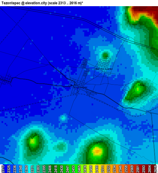
Below is the Elevation map of Tezontepec, which displays elevation range with different colors. Scale of the first map is from 2313 to 2616 m (7589 to 8583 ft) with average elevation of 2347.6 meters (=7702 ft) [note 1]
These maps also provides idea of topography and contour of this city, they are displayed at different zoom levels. More info about maps, scale and edge coordinates you can find below images.
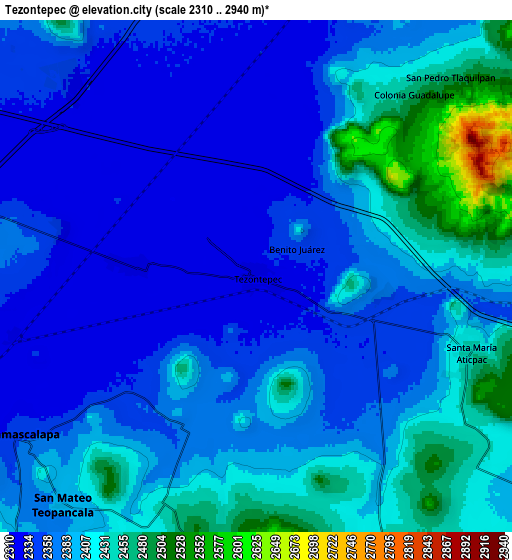
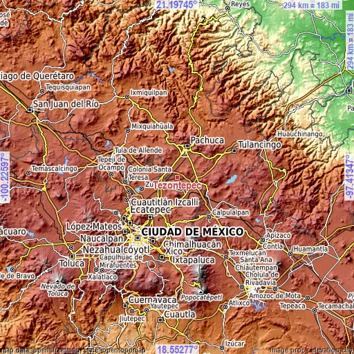
| \ | Map #1 | Map #2 | Topo.Map |
| Scale [m] | 2313..2616 m | 2310..2940 m | × |
| Scale [ft] | 7589..8583 ft | 7579..9646 ft | × |
| Average | 2347.6 m = 7702 ft | 2386.3 m = 7829 ft | × |
| Width | 9.19 km = 5.7 mi | 18.38 km = 11.4 mi | 294.1 km = 182.7 mi |
| Height | 9.19 km = 5.7 mi | 18.38 km = 11.4 mi | 294.1 km = 182.7 mi |
| ↑Max Latitude | 19.921951° | 19.963261° | 21.19745° |
| Latitude at center | 19.88063° | 19.88063° | 19.88063° |
| ↓Min Latitude | 19.839298° | 19.797956° | 18.55277° |
| ← Min Longitude | -98.863665° | -98.907611° | -100.22597° |
| Longitude center | -98.81972° | -98.81972° | -98.81972° |
| →Max Longitude | -98.775775° | -98.731829° | -97.41347° |
Nearby cities:
Cities around Tezontepec sort by population:
• Temascalapa elevation 2355 m
10.4 km,  235°
235°
• General Felipe Ángeles (Los Ángeles) 2342 m
11.3 km,  279°
279°
• Santa María Actipac 2450 m
8.2 km,  109°
109°
• Ixtlahuaca de Cuauhtémoc 2320 m
4.2 km,  271°
271°
• Teacalco 2438 m
9 km,  202°
202°
• Colonia Benito Juárez 2354 m
1.7 km,  53°
53°
• El Cid 2329 m
11.3 km,  262°
262°
• San Pedro Tlaquilpan 2475 m
10 km,  44°
44°
• Colonia Morelos 2330 m
1.1 km,  16°
16°
• Colonia Guadalupe 2477 m
8.6 km, 41°
• San Agustín Zapotlán 2382 m
11 km,  92°
92°
• Las Pintas 2334 m
7.3 km, 284°
Multilingual:
 En español:
Tezontepec elevación 2331 m.
 En France:
Tezontepec élévation 2331 m.
 Auf Deutsch:
Tezontepec höhe über dem Meeresspiegel ist 2331 m.

Sources and notes:
- [note 1] Map square and city borders are not equal. Map elevation data is calculated only from area inside that square.
- [src 1] Elevation data from geonames database provided with same terms of usage.
- [src 2] The elevation map of Tezontepec is generated using elevation data from NASA's 3 arcsec (90m) resolution SRTM data.
- [src 3] Base (background) map © OpenStreetMap contributors tiles are generated by Geofabrik and OpenTopoMap.
Copyright & License:
This Tezontepec Elevation Map is licensed under CC BY-SA. You may reuse any part from this page, if you give a proper credit by linking to this URL:
 More info on terms of use page.