Santa Catarina elevation
Santa Catarina (State of Mexico, Acolman de Nezahualcóyotl), Mexico elevation is 2273 meters and Santa Catarina elevation in feet is 7457 ft above sea level [src 1]. Santa Catarina is a populated place (feature code) with elevation that is 959 meters (3146 ft) bigger than average city elevation in Mexico.
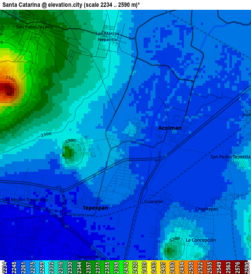
Below is the Elevation map of Santa Catarina, which displays elevation range with different colors. Scale of the first map is from 2234 to 2590 m (7329 to 8497 ft) with average elevation of 2282.1 meters (=7487 ft) [note 1]
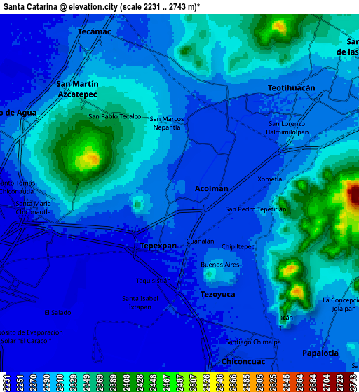
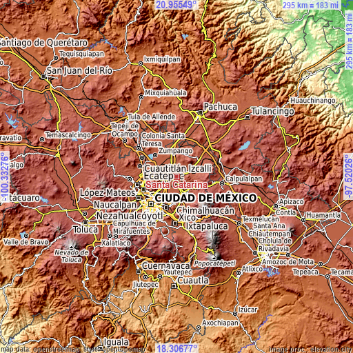
These maps also provides idea of topography and contour of this city, they are displayed at different zoom levels. More info about maps, scale and edge coordinates you can find below images.
| \ | Map #1 | Map #2 | Topo.Map |
| Scale [m] | 2234..2590 m | 2231..2743 m | × |
| Scale [ft] | 7329..8497 ft | 7320..8999 ft | × |
| Average | 2282.1 m = 7487 ft | 2291.2 m = 7517 ft | × |
| Width | 9.2 km = 5.7 mi | 18.41 km = 11.4 mi | 294.5 km = 183 mi |
| Height | 9.2 km = 5.7 mi | 18.41 km = 11.4 mi | 294.5 km = 183 mi |
| ↑Max Latitude | 19.677974° | 19.719348° | 20.95549° |
| Latitude at center | 19.63659° | 19.63659° | 19.63659° |
| ↓Min Latitude | 19.595195° | 19.55379° | 18.30677° |
| ← Min Longitude | -98.970455° | -99.014401° | -100.33276° |
| Longitude center | -98.92651° | -98.92651° | -98.92651° |
| →Max Longitude | -98.882565° | -98.838619° | -97.52026° |
Nearby cities:
Cities around Santa Catarina sort by population:
• Tepexpan elevation 2260 m
2.7 km,  202°
202°
• Tezoyuca 2276 m
5.1 km,  161°
161°
• Tequisistlán Primero 2238 m
5.2 km,  218°
218°
• Tequisistlán 2246 m
4.7 km, 198°
• Acolman de Netzahualcóyotl 2259 m
2 km,  79°
79°
• San Bartolo 2263 m
3.3 km,  50°
50°
• Atlatongo 2263 m
4.2 km,  34°
34°
• Xometla 2271 m
4.7 km, 81°
• San Marcos Nepantla 2292 m
3.7 km,  351°
351°
• Prados de San Juan 2385 m
5.1 km,  274°
274°
• San Pedro Tepetitlán 2294 m
4.1 km,  102°
102°
• La Concepción 2284 m
4.8 km,  144°
144°
Multilingual:
 En español:
Santa Catarina elevación 2273 m.
 En France:
Santa Catarina élévation 2273 m.
 Auf Deutsch:
Santa Catarina höhe über dem Meeresspiegel ist 2273 m.

Sources and notes:
- [note 1] Map square and city borders are not equal. Map elevation data is calculated only from area inside that square.
- [src 1] Elevation data from geonames database provided with same terms of usage.
- [src 2] The elevation map of Santa Catarina is generated using elevation data from NASA's 3 arcsec (90m) resolution SRTM data.
- [src 3] Base (background) map © OpenStreetMap contributors tiles are generated by Geofabrik and OpenTopoMap.
Copyright & License:
This Santa Catarina Elevation Map is licensed under CC BY-SA. You may reuse any part from this page, if you give a proper credit by linking to this URL:
 More info on terms of use page.