Cerro La Calera elevation
Cerro La Calera (State of Mexico, Zinacantepec), Mexico elevation is 3387 meters and Cerro La Calera elevation in feet is 11112 ft above sea level [src 1]. Cerro La Calera is a populated place (feature code) with elevation that is 2073 meters (6801 ft) bigger than average city elevation in Mexico.
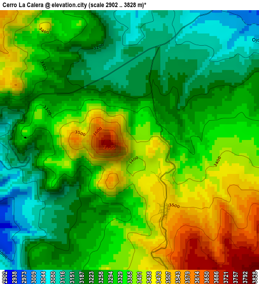
Below is the Elevation map of Cerro La Calera, which displays elevation range with different colors. Scale of the first map is from 2902 to 3828 m (9521 to 12559 ft) with average elevation of 3306.6 meters (=10848 ft) [note 1]
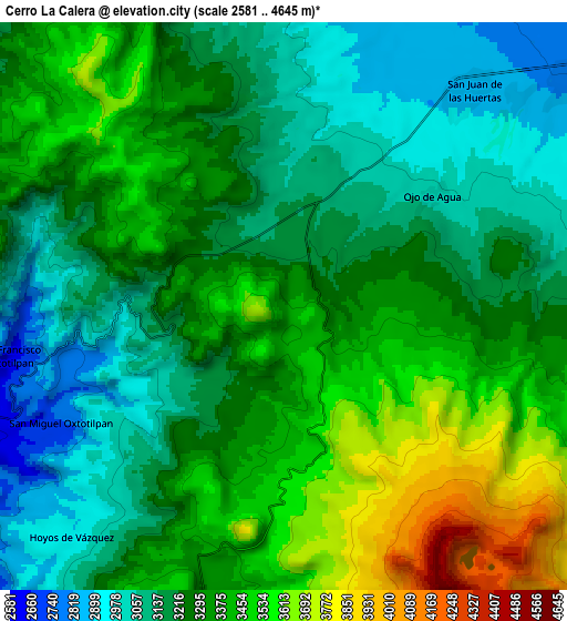
These maps also provides idea of topography and contour of this city, they are displayed at different zoom levels. More info about maps, scale and edge coordinates you can find below images.
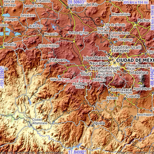
| \ | Map #1 | Map #2 | Topo.Map |
| Scale [m] | 2902..3828 m | 2581..4645 m | × |
| Scale [ft] | 9521..12559 ft | 8468..15240 ft | × |
| Average | 3306.6 m = 10848 ft | 3288.3 m = 10788 ft | × |
| Width | 9.23 km = 5.7 mi | 18.46 km = 11.5 mi | 295.3 km = 183.5 mi |
| Height | 9.23 km = 5.7 mi | 18.46 km = 11.5 mi | 295.4 km = 183.6 mi |
| ↑Max Latitude | 19.22483° | 19.266319° | 20.50603° |
| Latitude at center | 19.18333° | 19.18333° | 19.18333° |
| ↓Min Latitude | 19.14182° | 19.100299° | 17.84992° |
| ← Min Longitude | -99.860615° | -99.904561° | -101.22292° |
| Longitude center | -99.81667° | -99.81667° | -99.81667° |
| →Max Longitude | -99.772725° | -99.728779° | -98.41042° |
Nearby cities:
Cities around Cerro La Calera sort by population:
• San Antonio Acahualco elevation 2806 m
11.1 km,  25°
25°
• San Juan de las Huertas 2864 m
9.4 km,  40°
40°
• Barrio de México 2979 m
11.1 km,  353°
353°
• Colonia Morelos 2853 m
10.2 km,  46°
46°
• Tejalpa 2867 m
9.3 km, 35°
• Ojo de Agua 3020 m
6.1 km, 52°
• El Contadero de Matamoros 3049 m
6 km,  6°
6°
• San Pedro Tejalpa 2869 m
8.7 km,  17°
17°
• Colonia Cuauhtémoc 2891 m
7.8 km, 15°
• San Francisco Oxtotilpan 2642 m
9.2 km,  260°
260°
• San Miguel Oxtotilpan 2743 m
9.4 km,  242°
242°
• Loma de San Francisco 2927 m
11.1 km,  4°
4°
Multilingual:
 En español:
Cerro La Calera elevación 3387 m.
 En France:
Cerro La Calera élévation 3387 m.
 Auf Deutsch:
Cerro La Calera höhe über dem Meeresspiegel ist 3387 m.

Sources and notes:
- [note 1] Map square and city borders are not equal. Map elevation data is calculated only from area inside that square.
- [src 1] Elevation data from geonames database provided with same terms of usage.
- [src 2] The elevation map of Cerro La Calera is generated using elevation data from NASA's 3 arcsec (90m) resolution SRTM data.
- [src 3] Base (background) map © OpenStreetMap contributors tiles are generated by Geofabrik and OpenTopoMap.
Copyright & License:
This Cerro La Calera Elevation Map is licensed under CC BY-SA. You may reuse any part from this page, if you give a proper credit by linking to this URL:
 More info on terms of use page.