Arriaga elevation
Arriaga (Chiapas), Mexico elevation is 63 meters and Arriaga elevation in feet is 207 ft above sea level [src 1]. Arriaga is a seat of a second-order administrative division (feature code) with elevation that is 1251 meters (4104 ft) smaller than average city elevation in Mexico.
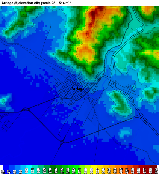
Below is the Elevation map of Arriaga, which displays elevation range with different colors. Scale of the first map is from 28 to 514 m (92 to 1686 ft) with average elevation of 98.4 meters (=323 ft) [note 1]
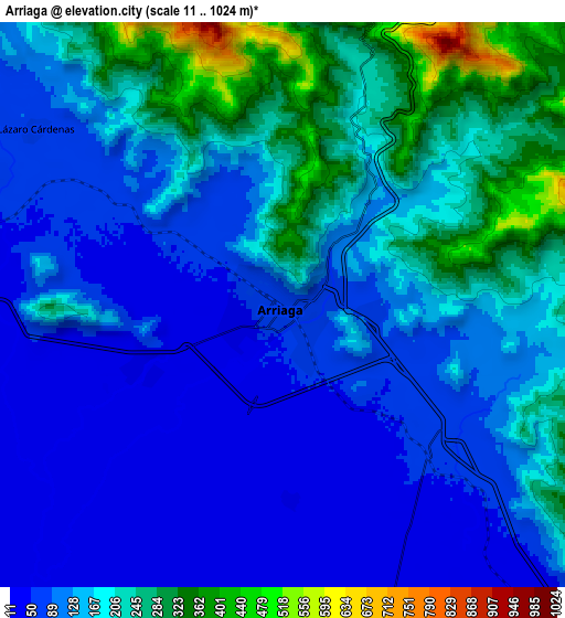
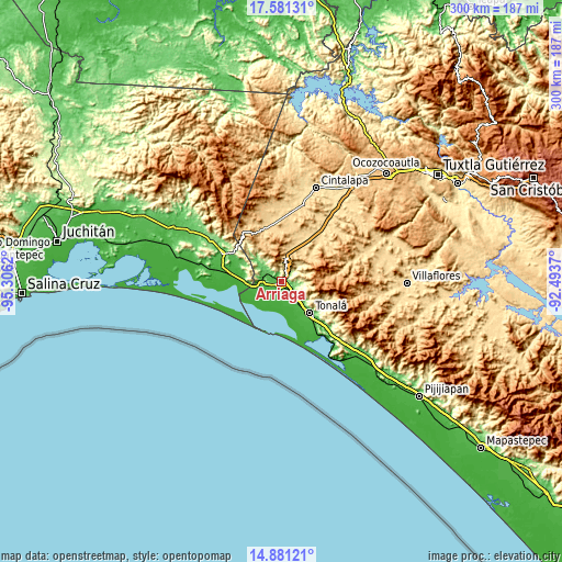
These maps also provides idea of topography and contour of this city, they are displayed at different zoom levels. More info about maps, scale and edge coordinates you can find below images.
| \ | Map #1 | Map #2 | Topo.Map |
| Scale [m] | 28..514 m | 11..1024 m | × |
| Scale [ft] | 92..1686 ft | 36..3360 ft | × |
| Average | 98.4 m = 323 ft | 151.5 m = 497 ft | × |
| Width | 9.38 km = 5.8 mi | 18.77 km = 11.7 mi | 300.2 km = 186.5 mi |
| Height | 9.38 km = 5.8 mi | 18.77 km = 11.7 mi | 300.2 km = 186.5 mi |
| ↑Max Latitude | 16.278078° | 16.320257° | 17.58131° |
| Latitude at center | 16.23589° | 16.23589° | 16.23589° |
| ↓Min Latitude | 16.193693° | 16.151486° | 14.88121° |
| ← Min Longitude | -93.943895° | -93.987841° | -95.3062° |
| Longitude center | -93.89995° | -93.89995° | -93.89995° |
| →Max Longitude | -93.856005° | -93.812059° | -92.4937° |
Nearby cities:
Cities around Arriaga sort by population:
• Tonalá elevation 50 m
22.4 km,  136°
136°
• Paredón 7 m
20.9 km,  170°
170°
• Emiliano Zapata 14 m
18.9 km,  248°
248°
• Tierra y Libertad 679 m
16.4 km,  14°
14°
• Tiltepec 693 m
17.9 km, 10°
• Azteca 37 m
5.3 km, 247°
• La Gloria 2 m
24 km,  244°
244°
• Ignacio Ramírez 15 m
14.2 km, 168°
• La Línea 4 m
18.6 km,  231°
231°
• Huizachal 23 m
23.1 km,  152°
152°
• Lázaro Cárdenas 77 m
10.1 km,  305°
305°
• Los Corazones 16 m
18.8 km,  261°
261°
Multilingual:
 En español:
Arriaga elevación 63 m.
 En France:
Arriaga élévation 63 m.


Sources and notes:
- [note 1] Map square and city borders are not equal. Map elevation data is calculated only from area inside that square.
- [src 1] Elevation data from geonames database provided with same terms of usage.
- [src 2] The elevation map of Arriaga is generated using elevation data from NASA's 3 arcsec (90m) resolution SRTM data.
- [src 3] Base (background) map © OpenStreetMap contributors tiles are generated by Geofabrik and OpenTopoMap.
Copyright & License:
This Arriaga Elevation Map is licensed under CC BY-SA. You may reuse any part from this page, if you give a proper credit by linking to this URL:
 More info on terms of use page.