Tiltepec elevation
Tiltepec (Chiapas, Jiquipilas), Mexico elevation is 693 meters and Tiltepec elevation in feet is 2274 ft above sea level [src 1]. Tiltepec is a populated place (feature code) with elevation that is 621 meters (2037 ft) smaller than average city elevation in Mexico.
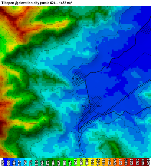
Below is the Elevation map of Tiltepec, which displays elevation range with different colors. Scale of the first map is from 624 to 1432 m (2047 to 4698 ft) with average elevation of 812.4 meters (=2665 ft) [note 1]
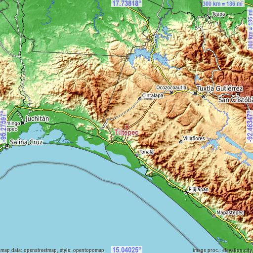
These maps also provides idea of topography and contour of this city, they are displayed at different zoom levels. More info about maps, scale and edge coordinates you can find below images.
| \ | Map #1 | Topo.Map |
| Scale [m] | 624..1432 m | × |
| Scale [ft] | 2047..4698 ft | × |
| Average | 812.4 m = 2665 ft | × |
| Width | 9.38 km = 5.8 mi | 300 km = 186.4 mi |
| Height | 9.38 km = 5.8 mi | 300 km = 186.4 mi |
| ↑Max Latitude | 16.436044° | 17.73818° |
| Latitude at center | 16.39389° | 16.39389° |
| ↓Min Latitude | 16.351727° | 15.04025° |
| ← Min Longitude | -93.913665° | -95.27597° |
| Longitude center | -93.86972° | -93.86972° |
| →Max Longitude | -93.825775° | -92.46347° |
Nearby cities:
Cities around Tiltepec sort by population:
• Arriaga elevation 63 m
17.9 km,  190°
190°
• Tierra y Libertad 679 m
1.9 km,  149°
149°
• Cereso 14 (El Amate) 612 m
23.4 km,  17°
17°
• José María Pino Suárez 627 m
18.7 km,  48°
48°
• Azteca 37 m
21.2 km,  202°
202°
• Villamorelos 707 m
11.4 km,  327°
327°
• Nueva Tenochtitlán (Rizo de Oro) 795 m
24.3 km,  292°
292°
• Pomposo Castellanos 620 m
21.8 km,  0°
0°
• Mérida 664 m
20.1 km, 16°
• Cuauhtémoc 582 m
23.9 km,  43°
43°
• Julián Grajales 610 m
17 km,  76°
76°
• Lázaro Cárdenas 77 m
16.4 km,  224°
224°
Multilingual:
 En español:
Tiltepec elevación 693 m.
 En France:
Tiltepec élévation 693 m.
 Auf Deutsch:
Tiltepec höhe über dem Meeresspiegel ist 693 m.

Sources and notes:
- [note 1] Map square and city borders are not equal. Map elevation data is calculated only from area inside that square.
- [src 1] Elevation data from geonames database provided with same terms of usage.
- [src 2] The elevation map of Tiltepec is generated using elevation data from NASA's 3 arcsec (90m) resolution SRTM data.
- [src 3] Base (background) map © OpenStreetMap contributors tiles are generated by Geofabrik and OpenTopoMap.
Copyright & License:
This Tiltepec Elevation Map is licensed under CC BY-SA. You may reuse any part from this page, if you give a proper credit by linking to this URL:
 More info on terms of use page.