Presidente Echeverría (Laja Tendida) elevation
Presidente Echeverría (Laja Tendida) (Chiapas, Venustiano Carranza), Mexico elevation is 545 meters and Presidente Echeverría (Laja Tendida) elevation in feet is 1788 ft above sea level [src 1]. Presidente Echeverría (Laja Tendida) is a populated place (feature code) with elevation that is 769 meters (2523 ft) smaller than average city elevation in Mexico.
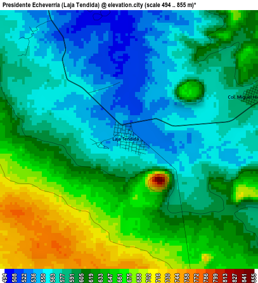
Below is the Elevation map of Presidente Echeverría (Laja Tendida), which displays elevation range with different colors. Scale of the first map is from 494 to 855 m (1621 to 2805 ft) with average elevation of 605.2 meters (=1986 ft) [note 1]
These maps also provides idea of topography and contour of this city, they are displayed at different zoom levels. More info about maps, scale and edge coordinates you can find below images.

| \ | Map #1 | Topo.Map |
| Scale [m] | 494..855 m | × |
| Scale [ft] | 1621..2805 ft | × |
| Average | 605.2 m = 1986 ft | × |
| Width | 9.38 km = 5.8 mi | 300.1 km = 186.5 mi |
| Height | 9.38 km = 5.8 mi | 300.1 km = 186.5 mi |
| ↑Max Latitude | 16.377997° | 17.68054° |
| Latitude at center | 16.33583° | 16.33583° |
| ↓Min Latitude | 16.293654° | 14.98181° |
| ← Min Longitude | -92.712555° | -94.07486° |
| Longitude center | -92.66861° | -92.66861° |
| →Max Longitude | -92.624665° | -91.26236° |
Nearby cities:
Cities around Presidente Echeverría (Laja Tendida) sort by population:
• Venustiano Carranza elevation 775 m
11.3 km,  88°
88°
• Totolapa 655 m
23.1 km,  356°
356°
• Nicolás Ruiz 751 m
14.4 km,  38°
38°
• Ricardo Flores Magón 480 m
7.1 km,  335°
335°
• Nuevo León 1130 m
19.7 km,  31°
31°
• San Francisco (El Calvito) 638 m
11.5 km,  97°
97°
• Vicente Guerrero 491 m
12.4 km, 337°
• Paraíso del Grijalva 667 m
12.5 km,  167°
167°
• Unión Buena Vista 533 m
23.1 km,  316°
316°
• Guadalupe Victoria 967 m
14.6 km,  58°
58°
• Mariano Matamoros 1051 m
18.5 km, 28°
• Miguel Hidalgo 595 m
4.6 km,  68°
68°
Multilingual:
 En español:
Presidente Echeverría (Laja Tendida) elevación 545 m.
 En France:
Presidente Echeverría (Laja Tendida) élévation 545 m.
 Auf Deutsch:
Presidente Echeverría (Laja Tendida) höhe über dem Meeresspiegel ist 545 m.
 На русском:
Presidente Echeverría (Laja Tendida) высота над уровнем моря 545 м
Sources and notes:
- [note 1] Map square and city borders are not equal. Map elevation data is calculated only from area inside that square.
- [src 1] Elevation data from geonames database provided with same terms of usage.
- [src 2] The elevation map of Presidente Echeverría (Laja Tendida) is generated using elevation data from NASA's 3 arcsec (90m) resolution SRTM data.
- [src 3] Base (background) map © OpenStreetMap contributors tiles are generated by Geofabrik and OpenTopoMap.
Copyright & License:
This Presidente Echeverría (Laja Tendida) Elevation Map is licensed under CC BY-SA. You may reuse any part from this page, if you give a proper credit by linking to this URL:
 More info on terms of use page.