Efraín A. Gutiérrez elevation
Efraín A. Gutiérrez (Chiapas, Comitán Municipality), Mexico elevation is 1865 meters and Efraín A. Gutiérrez elevation in feet is 6119 ft above sea level [src 1]. Efraín A. Gutiérrez is a populated place (feature code) with elevation that is 551 meters (1808 ft) bigger than average city elevation in Mexico.
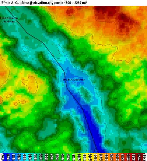
Below is the Elevation map of Efraín A. Gutiérrez, which displays elevation range with different colors. Scale of the first map is from 1806 to 2289 m (5925 to 7510 ft) with average elevation of 2004.1 meters (=6575 ft) [note 1]
These maps also provides idea of topography and contour of this city, they are displayed at different zoom levels. More info about maps, scale and edge coordinates you can find below images.
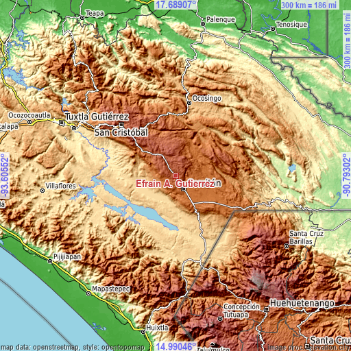
| \ | Map #1 | Topo.Map |
| Scale [m] | 1806..2289 m | × |
| Scale [ft] | 5925..7510 ft | × |
| Average | 2004.1 m = 6575 ft | × |
| Width | 9.38 km = 5.8 mi | 300.1 km = 186.5 mi |
| Height | 9.38 km = 5.8 mi | 300.1 km = 186.5 mi |
| ↑Max Latitude | 16.386585° | 17.68907° |
| Latitude at center | 16.34442° | 16.34442° |
| ↓Min Latitude | 16.302246° | 14.99046° |
| ← Min Longitude | -92.243215° | -93.60552° |
| Longitude center | -92.19927° | -92.19927° |
| →Max Longitude | -92.155325° | -90.79302° |
Nearby cities:
Cities around Efraín A. Gutiérrez sort by population:
• Comitán elevation 1632 m
12.8 km,  147°
147°
• Villahermosa Yaluma 1728 m
13 km,  95°
95°
• Yasha 1749 m
14.9 km,  69°
69°
• San José Yocnajab 1600 m
15.7 km,  130°
130°
• Los Riegos 1589 m
9.1 km,  118°
118°
• Cash 1594 m
14 km, 129°
• Señor del Pozo 1611 m
10.8 km, 119°
• Zaragoza la Montaña 2224 m
8 km,  355°
355°
• Ochusjob 1422 m
14.4 km,  202°
202°
• Tzinil 1161 m
16.3 km,  233°
233°
• Chacaljocóm 1823 m
5.3 km,  161°
161°
• Lomantán 1776 m
17.9 km,  53°
53°
Multilingual:
 En español:
Efraín A. Gutiérrez elevación 1865 m.
 En France:
Efraín A. Gutiérrez élévation 1865 m.
 Auf Deutsch:
Efraín A. Gutiérrez höhe über dem Meeresspiegel ist 1865 m.
 На русском:
Efraín A. Gutiérrez высота над уровнем моря 1865 м
Sources and notes:
- [note 1] Map square and city borders are not equal. Map elevation data is calculated only from area inside that square.
- [src 1] Elevation data from geonames database provided with same terms of usage.
- [src 2] The elevation map of Efraín A. Gutiérrez is generated using elevation data from NASA's 3 arcsec (90m) resolution SRTM data.
- [src 3] Base (background) map © OpenStreetMap contributors tiles are generated by Geofabrik and OpenTopoMap.
Copyright & License:
This Efraín A. Gutiérrez Elevation Map is licensed under CC BY-SA. You may reuse any part from this page, if you give a proper credit by linking to this URL:
 More info on terms of use page.