Benito Juárez elevation
Benito Juárez (Hidalgo, Mineral del Chico), Mexico elevation is 2478 meters and Benito Juárez elevation in feet is 8130 ft above sea level [src 1]. Benito Juárez is a populated place (feature code) with elevation that is 1164 meters (3819 ft) bigger than average city elevation in Mexico.
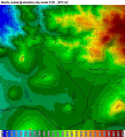
Below is the Elevation map of Benito Juárez, which displays elevation range with different colors. Scale of the first map is from 2138 to 3073 m (7014 to 10082 ft) with average elevation of 2513.8 meters (=8247 ft) [note 1]
These maps also provides idea of topography and contour of this city, they are displayed at different zoom levels. More info about maps, scale and edge coordinates you can find below images.
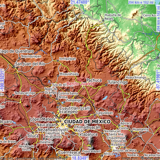
| \ | Map #1 | Topo.Map |
| Scale [m] | 2138..3073 m | × |
| Scale [ft] | 7014..10082 ft | × |
| Average | 2513.8 m = 8247 ft | × |
| Width | 9.17 km = 5.7 mi | 293.5 km = 182.4 mi |
| Height | 9.17 km = 5.7 mi | 293.6 km = 182.4 mi |
| ↑Max Latitude | 20.201717° | 21.47488° |
| Latitude at center | 20.16047° | 20.16047° |
| ↓Min Latitude | 20.119212° | 18.8349° |
| ← Min Longitude | -98.870005° | -100.23231° |
| Longitude center | -98.82606° | -98.82606° |
| →Max Longitude | -98.782115° | -97.41981° |
Nearby cities:
Cities around Benito Juárez sort by population:
• Pachuca de Soto elevation 2393 m
10.8 km,  116°
116°
• San Agustín Tlaxiaca 2368 m
8.1 km,  231°
231°
• Santiago Tlapacoya 2507 m
5.7 km,  184°
184°
• El Arenal 2050 m
11.1 km,  308°
308°
• San Juan Tilcuautla 2517 m
2.6 km,  94°
94°
• El Huixmí 2458 m
9.4 km, 175°
• San Miguel Cerezo (El Cerezo) 2677 m
10.2 km, 90°
• La Estanzuela 2769 m
7.5 km,  74°
74°
• San Juan Solís 2208 m
11 km,  268°
268°
• Camelia (Barrio la Camelia) 2580 m
10.9 km,  96°
96°
• La Sala (La Caliente) 2144 m
7.1 km,  317°
317°
• Rinconadas de San Francisco 2360 m
12.1 km,  150°
150°
Multilingual:
 En español:
Benito Juárez elevación 2478 m.
 En France:
Benito Juárez élévation 2478 m.
 Auf Deutsch:
Benito Juárez höhe über dem Meeresspiegel ist 2478 m.

Sources and notes:
- [note 1] Map square and city borders are not equal. Map elevation data is calculated only from area inside that square.
- [src 1] Elevation data from geonames database provided with same terms of usage.
- [src 2] The elevation map of Benito Juárez is generated using elevation data from NASA's 3 arcsec (90m) resolution SRTM data.
- [src 3] Base (background) map © OpenStreetMap contributors tiles are generated by Geofabrik and OpenTopoMap.
Copyright & License:
This Benito Juárez Elevation Map is licensed under CC BY-SA. You may reuse any part from this page, if you give a proper credit by linking to this URL:
 More info on terms of use page.