San Francisco elevation
San Francisco (Hidalgo, Huazalingo), Mexico elevation is 1034 meters and San Francisco elevation in feet is 3392 ft above sea level [src 1]. San Francisco is a populated place (feature code) with elevation that is 280 meters (919 ft) smaller than average city elevation in Mexico.
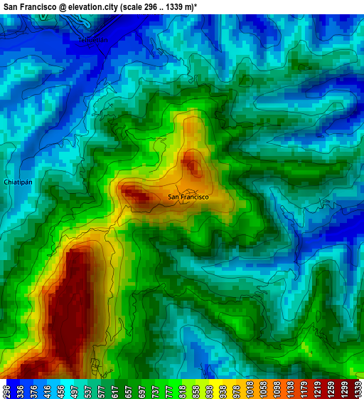
Below is the Elevation map of San Francisco, which displays elevation range with different colors. Scale of the first map is from 296 to 1339 m (971 to 4393 ft) with average elevation of 624 meters (=2047 ft) [note 1]
These maps also provides idea of topography and contour of this city, they are displayed at different zoom levels. More info about maps, scale and edge coordinates you can find below images.
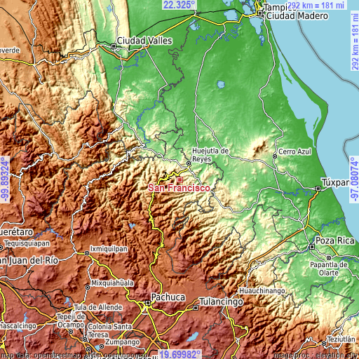
| \ | Map #1 | Topo.Map |
| Scale [m] | 296..1339 m | × |
| Scale [ft] | 971..4393 ft | × |
| Average | 624 m = 2047 ft | × |
| Width | 9.12 km = 5.7 mi | 291.9 km = 181.4 mi |
| Height | 9.12 km = 5.7 mi | 291.9 km = 181.4 mi |
| ↑Max Latitude | 21.059206° | 22.325° |
| Latitude at center | 21.01819° | 21.01819° |
| ↓Min Latitude | 20.977163° | 19.69982° |
| ← Min Longitude | -98.530935° | -99.89324° |
| Longitude center | -98.48699° | -98.48699° |
| →Max Longitude | -98.443045° | -97.08074° |
Nearby cities:
Cities around San Francisco sort by population:
• Tehuetlán elevation 324 m
4.5 km,  330°
330°
• Tlalchiyahualica 230 m
10.5 km,  120°
120°
• Pahuatlán 278 m
5.8 km,  10°
10°
• Xiquila 228 m
8.1 km,  34°
34°
• Chatipán 443 m
4.2 km,  272°
272°
• Ixcatlán 865 m
8.6 km,  324°
324°
• Mecatlán 453 m
12.6 km,  136°
136°
• San Andrés (San Andrés Chichayotla) 1164 m
12.9 km,  217°
217°
• Acoapa 277 m
11.4 km,  359°
359°
• Tepetitla 485 m
12.4 km, 120°
• San José 431 m
12.5 km,  296°
296°
• Machetla 306 m
4.7 km,  350°
350°
Multilingual:
 En español:
San Francisco elevación 1034 m.
 En France:
San Francisco élévation 1034 m.
 Auf Deutsch:
San Francisco höhe über dem Meeresspiegel ist 1034 m.

Sources and notes:
- [note 1] Map square and city borders are not equal. Map elevation data is calculated only from area inside that square.
- [src 1] Elevation data from geonames database provided with same terms of usage.
- [src 2] The elevation map of San Francisco is generated using elevation data from NASA's 3 arcsec (90m) resolution SRTM data.
- [src 3] Base (background) map © OpenStreetMap contributors tiles are generated by Geofabrik and OpenTopoMap.
Copyright & License:
This San Francisco Elevation Map is licensed under CC BY-SA. You may reuse any part from this page, if you give a proper credit by linking to this URL:
 More info on terms of use page.