Chatipán elevation
Chatipán (Hidalgo, Huazalingo), Mexico elevation is 443 meters and Chatipán elevation in feet is 1453 ft above sea level [src 1]. Chatipán is a populated place (feature code) with elevation that is 871 meters (2858 ft) smaller than average city elevation in Mexico.
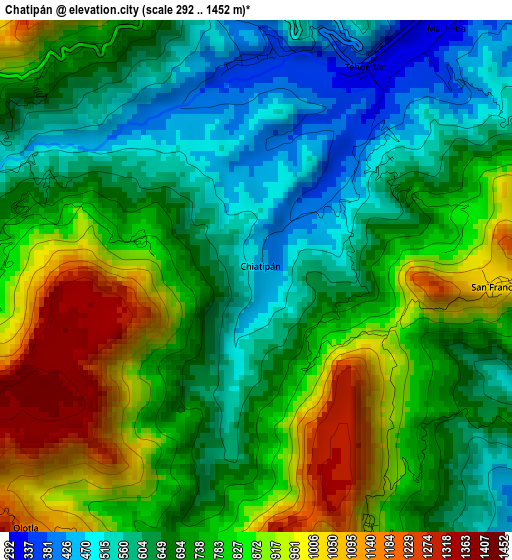
Below is the Elevation map of Chatipán, which displays elevation range with different colors. Scale of the first map is from 292 to 1452 m (958 to 4764 ft) with average elevation of 744.1 meters (=2441 ft) [note 1]
These maps also provides idea of topography and contour of this city, they are displayed at different zoom levels. More info about maps, scale and edge coordinates you can find below images.
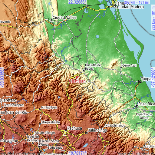
| \ | Map #1 | Topo.Map |
| Scale [m] | 292..1452 m | × |
| Scale [ft] | 958..4764 ft | × |
| Average | 744.1 m = 2441 ft | × |
| Width | 9.12 km = 5.7 mi | 291.9 km = 181.4 mi |
| Height | 9.12 km = 5.7 mi | 291.9 km = 181.4 mi |
| ↑Max Latitude | 21.061075° | 22.32686° |
| Latitude at center | 21.02006° | 21.02006° |
| ↓Min Latitude | 20.979033° | 19.70171° |
| ← Min Longitude | -98.571255° | -99.93356° |
| Longitude center | -98.52731° | -98.52731° |
| →Max Longitude | -98.483365° | -97.12106° |
Nearby cities:
Cities around Chatipán sort by population:
• Coacuilco elevation 344 m
11.1 km,  326°
326°
• Tehuetlán 324 m
4.2 km,  27°
27°
• Pahuatlán 278 m
7.6 km,  43°
43°
• Xiquila 228 m
10.9 km,  53°
53°
• Ixcatlán 865 m
6.9 km,  353°
353°
• San Francisco 1034 m
4.2 km,  92°
92°
• Acahuasco 888 m
9.6 km,  228°
228°
• San Andrés (San Andrés Chichayotla) 1164 m
11 km,  199°
199°
• Acoapa 277 m
12 km,  20°
20°
• San José 431 m
8.9 km,  308°
308°
• Chichatla 1095 m
12.6 km,  237°
237°
• Machetla 306 m
5.6 km, 37°
Multilingual:
 En español:
Chiatipán, Chatipán elevación 443 m.
 En France:
Chatipán élévation 443 m.
 Auf Deutsch:
Chatipán höhe über dem Meeresspiegel ist 443 m.

Sources and notes:
- [note 1] Map square and city borders are not equal. Map elevation data is calculated only from area inside that square.
- [src 1] Elevation data from geonames database provided with same terms of usage.
- [src 2] The elevation map of Chatipán is generated using elevation data from NASA's 3 arcsec (90m) resolution SRTM data.
- [src 3] Base (background) map © OpenStreetMap contributors tiles are generated by Geofabrik and OpenTopoMap.
Copyright & License:
This Chatipán Elevation Map is licensed under CC BY-SA. You may reuse any part from this page, if you give a proper credit by linking to this URL:
 More info on terms of use page.