Miguel Hidalgo elevation
Miguel Hidalgo (Tabasco, Comalcalco), Mexico elevation is 14 meters and Miguel Hidalgo elevation in feet is 46 ft above sea level [src 1]. Miguel Hidalgo is a populated place (feature code) with elevation that is 1300 meters (4265 ft) smaller than average city elevation in Mexico.
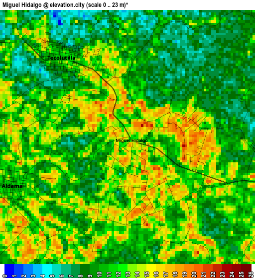
Below is the Elevation map of Miguel Hidalgo, which displays elevation range with different colors. Scale of the first map is from 0 to 23 m (0 to 75 ft) with average elevation of 11 meters (=36 ft) [note 1]
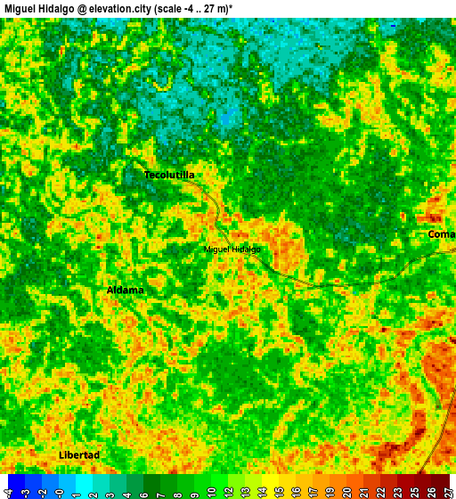
These maps also provides idea of topography and contour of this city, they are displayed at different zoom levels. More info about maps, scale and edge coordinates you can find below images.
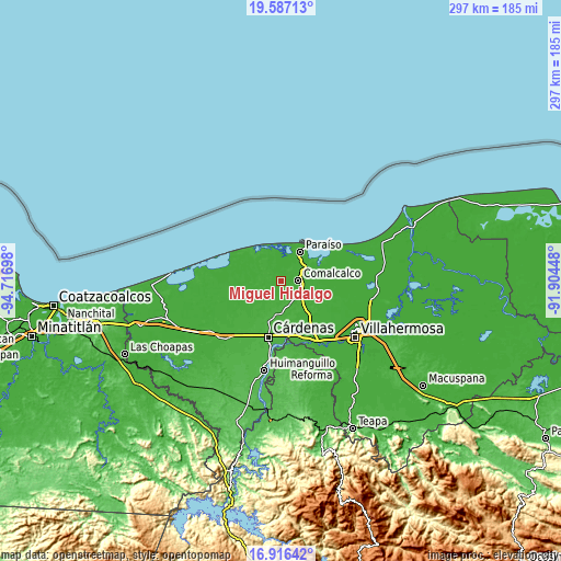
| \ | Map #1 | Map #2 | Topo.Map |
| Scale [m] | 0..23 m | -4..27 m | × |
| Scale [ft] | 0..75 ft | -13..89 ft | × |
| Average | 11 m = 36 ft | 10.6 m = 35 ft | × |
| Width | 9.28 km = 5.8 mi | 18.56 km = 11.5 mi | 297 km = 184.5 mi |
| Height | 9.28 km = 5.8 mi | 18.56 km = 11.5 mi | 297 km = 184.5 mi |
| ↑Max Latitude | 18.298638° | 18.340356° | 19.58713° |
| Latitude at center | 18.25691° | 18.25691° | 18.25691° |
| ↓Min Latitude | 18.215172° | 18.173424° | 16.91642° |
| ← Min Longitude | -93.354675° | -93.398621° | -94.71698° |
| Longitude center | -93.31073° | -93.31073° | -93.31073° |
| →Max Longitude | -93.266785° | -93.222839° | -91.90448° |
Nearby cities:
Cities around Miguel Hidalgo sort by population:
• Comalcalco elevation 12 m
9.2 km,  85°
85°
• Villa Tecolutilla 11 m
3.8 km,  320°
320°
• Villa Aldama 12 m
4.6 km,  247°
247°
• Arena 1ra. Sección 13 m
8.6 km,  223°
223°
• Reforma 9 m
5.9 km, 215°
• La Lucha 14 m
8.6 km,  187°
187°
• Ignacio Gutiérrez Gómez 12 m
9.2 km,  264°
264°
• El Tortuguero 11 m
6.9 km,  23°
23°
• Occidente 4ta. Sección 10 m
9.6 km,  57°
57°
• Betania 12 m
2.8 km,  337°
337°
• Sargento López 2da. Sección (El Chuzo) 14 m
6.7 km,  163°
163°
• Ignacio Zaragoza 1ra. Sección 8 m
8.7 km, 342°
Multilingual:
 En español:
Miguel Hidalgo elevación 14 m.
 En France:
Miguel Hidalgo élévation 14 m.
 Auf Deutsch:
Miguel Hidalgo höhe über dem Meeresspiegel ist 14 m.

Sources and notes:
- [note 1] Map square and city borders are not equal. Map elevation data is calculated only from area inside that square.
- [src 1] Elevation data from geonames database provided with same terms of usage.
- [src 2] The elevation map of Miguel Hidalgo is generated using elevation data from NASA's 3 arcsec (90m) resolution SRTM data.
- [src 3] Base (background) map © OpenStreetMap contributors tiles are generated by Geofabrik and OpenTopoMap.
Copyright & License:
This Miguel Hidalgo Elevation Map is licensed under CC BY-SA. You may reuse any part from this page, if you give a proper credit by linking to this URL:
 More info on terms of use page.