El Coyul elevation
El Coyul (Oaxaca, San Pedro Huamelula), Mexico elevation is 31 meters and El Coyul elevation in feet is 102 ft above sea level [src 1]. El Coyul is a populated place (feature code) with elevation that is 1283 meters (4209 ft) smaller than average city elevation in Mexico.
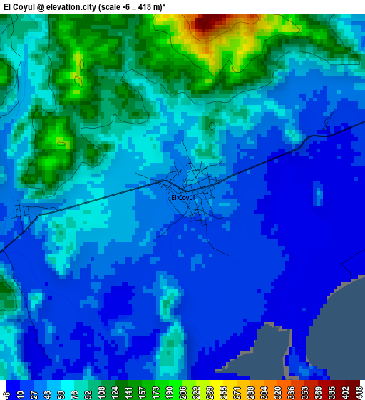
Below is the Elevation map of El Coyul, which displays elevation range with different colors. Scale of the first map is from -6 to 418 m (-20 to 1371 ft) with average elevation of 61.3 meters (=201 ft) [note 1]
These maps also provides idea of topography and contour of this city, they are displayed at different zoom levels. More info about maps, scale and edge coordinates you can find below images.
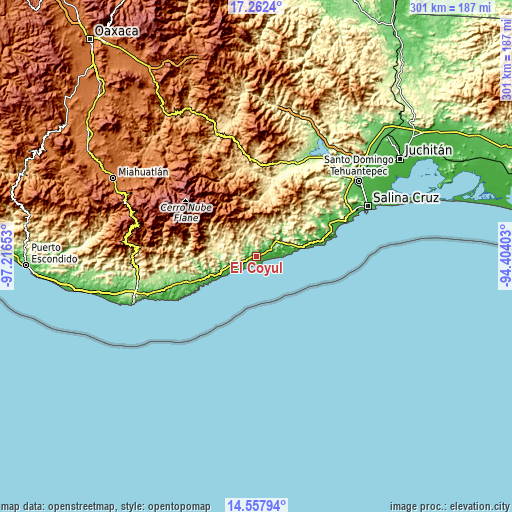
| \ | Map #1 | Topo.Map |
| Scale [m] | -6..418 m | × |
| Scale [ft] | -20..1371 ft | × |
| Average | 61.3 m = 201 ft | × |
| Width | 9.4 km = 5.8 mi | 300.7 km = 186.8 mi |
| Height | 9.4 km = 5.8 mi | 300.7 km = 186.8 mi |
| ↑Max Latitude | 15.956976° | 17.2624° |
| Latitude at center | 15.91472° | 15.91472° |
| ↓Min Latitude | 15.872455° | 14.55794° |
| ← Min Longitude | -95.854225° | -97.21653° |
| Longitude center | -95.81028° | -95.81028° |
| →Max Longitude | -95.766335° | -94.40403° |
Nearby cities:
Cities around El Coyul sort by population:
• Crucecita elevation 37 m
38.3 km,  244°
244°
• Sector H Tres 77 m
39.6 km,  245°
245°
• San Pedro Huamelula 81 m
19.7 km,  50°
50°
• Santiago Astata 38 m
16.5 km,  60°
60°
• Merced del Potrero 633 m
31.5 km,  297°
297°
• Tapanalá 40 m
10.8 km, 57°
• Santa María Huamelula 66 m
14.3 km, 52°
• Santa María Zapotitlán 1504 m
24.1 km,  349°
349°
• Santa María Xadani 350 m
28.4 km,  277°
277°
• San Miguel del Puerto 343 m
39 km,  271°
271°
• Asunción Tlacolulita 365 m
43.7 km,  11°
11°
• Santa María Ecatepec 1830 m
41.8 km, 349°
Multilingual:
 En español:
El Coyul elevación 31 m.
 En France:
El Coyul élévation 31 m.


Sources and notes:
- [note 1] Map square and city borders are not equal. Map elevation data is calculated only from area inside that square.
- [src 1] Elevation data from geonames database provided with same terms of usage.
- [src 2] The elevation map of El Coyul is generated using elevation data from NASA's 3 arcsec (90m) resolution SRTM data.
- [src 3] Base (background) map © OpenStreetMap contributors tiles are generated by Geofabrik and OpenTopoMap.
Copyright & License:
This El Coyul Elevation Map is licensed under CC BY-SA. You may reuse any part from this page, if you give a proper credit by linking to this URL:
 More info on terms of use page.