Crucecita elevation
Crucecita (Oaxaca, Santa María Huatulco), Mexico elevation is 37 meters and Crucecita elevation in feet is 121 ft above sea level [src 1]. Crucecita is a populated place (feature code) with elevation that is 1277 meters (4190 ft) smaller than average city elevation in Mexico.
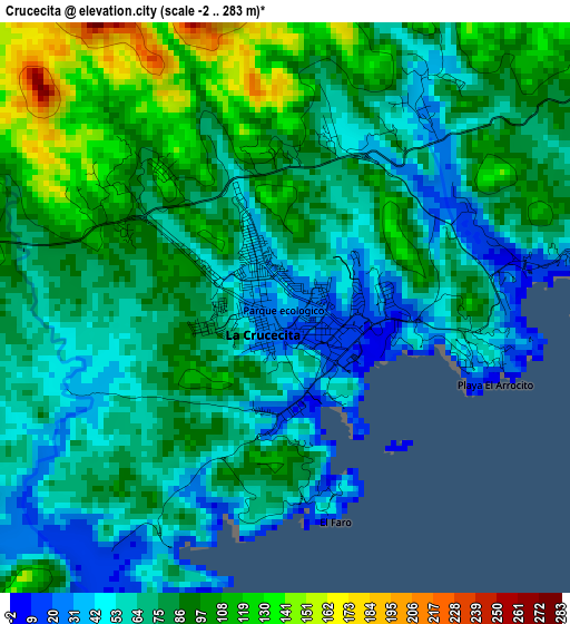
Below is the Elevation map of Crucecita, which displays elevation range with different colors. Scale of the first map is from -2 to 283 m (-7 to 928 ft) with average elevation of 77.4 meters (=254 ft) [note 1]
These maps also provides idea of topography and contour of this city, they are displayed at different zoom levels. More info about maps, scale and edge coordinates you can find below images.
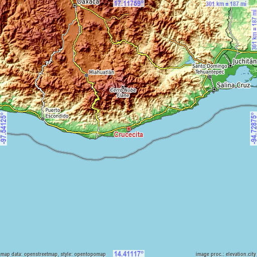
| \ | Map #1 | Map #2 | Topo.Map |
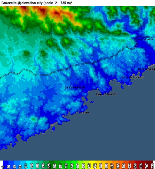
| Scale [m] | -2..283 m | -2..735 m | × |
| Scale [ft] | -7..928 ft | -7..2411 ft | × |
| Average | 77.4 m = 254 ft | 136.7 m = 448 ft | × |
| Width | 9.4 km = 5.8 mi | 18.81 km = 11.7 mi | 300.9 km = 187 mi |
| Height | 9.4 km = 5.8 mi | 18.81 km = 11.7 mi | 300.9 km = 187 mi |
| ↑Max Latitude | 15.811177° | 15.853455° | 17.11759° |
| Latitude at center | 15.76889° | 15.76889° | 15.76889° |
| ↓Min Latitude | 15.726594° | 15.684289° | 14.41117° |
| ← Min Longitude | -96.178945° | -96.222891° | -97.54125° |
| Longitude center | -96.135° | -96.135° | -96.135° |
| →Max Longitude | -96.091055° | -96.047109° | -94.72875° |
Nearby cities:
Cities around Crucecita sort by population:
• Santa María Huatulco elevation 230 m
21.1 km,  289°
289°
• Sector H Tres 77 m
1.3 km,  256°
256°
• Merced del Potrero 633 m
31.7 km,  12°
12°
• Benito Juárez 339 m
23.8 km,  301°
301°
• Cuapinolito (Azulillo) 214 m
20.5 km, 286°
• San Miguel Figueroa 205 m
28.9 km,  273°
273°
• La Erradura 216 m
22.6 km, 288°
• Santa María Xadani 350 m
21 km,  18°
18°
• San Isidro Apango 208 m
24.3 km,  280°
280°
• Santiago Xanica 1244 m
28.5 km,  340°
340°
• San Miguel del Puerto 343 m
17.5 km,  345°
345°
• San Mateo Piñas 1051 m
33.4 km,  320°
320°
Multilingual:
 En español:
Crucecita elevación 37 m.
 En France:
Crucecita élévation 37 m.
 Auf Deutsch:
Crucecita höhe über dem Meeresspiegel ist 37 m.

Sources and notes:
- [note 1] Map square and city borders are not equal. Map elevation data is calculated only from area inside that square.
- [src 1] Elevation data from geonames database provided with same terms of usage.
- [src 2] The elevation map of Crucecita is generated using elevation data from NASA's 3 arcsec (90m) resolution SRTM data.
- [src 3] Base (background) map © OpenStreetMap contributors tiles are generated by Geofabrik and OpenTopoMap.
Copyright & License:
This Crucecita Elevation Map is licensed under CC BY-SA. You may reuse any part from this page, if you give a proper credit by linking to this URL:
 More info on terms of use page.