La Reforma elevation
La Reforma (Oaxaca), Mexico elevation is 845 meters and La Reforma elevation in feet is 2772 ft above sea level [src 1]. La Reforma is a populated place (feature code) with elevation that is 469 meters (1539 ft) smaller than average city elevation in Mexico.
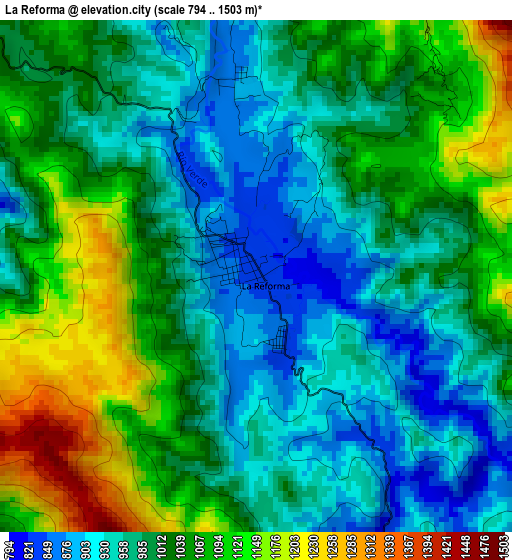
Below is the Elevation map of La Reforma, which displays elevation range with different colors. Scale of the first map is from 794 to 1503 m (2605 to 4931 ft) with average elevation of 1013.8 meters (=3326 ft) [note 1]
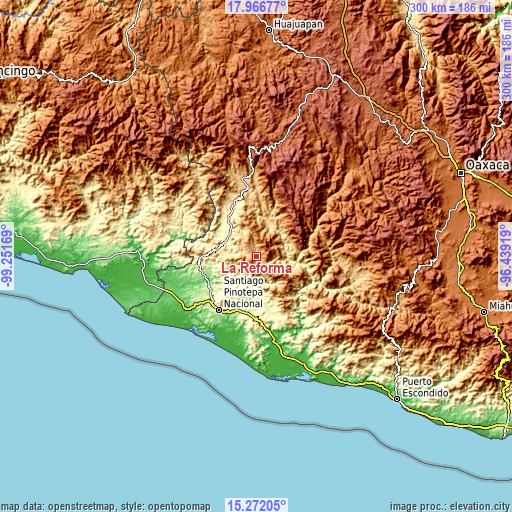
These maps also provides idea of topography and contour of this city, they are displayed at different zoom levels. More info about maps, scale and edge coordinates you can find below images.
| \ | Map #1 | Topo.Map |
| Scale [m] | 794..1503 m | × |
| Scale [ft] | 2605..4931 ft | × |
| Average | 1013.8 m = 3326 ft | × |
| Width | 9.36 km = 5.8 mi | 299.6 km = 186.2 mi |
| Height | 9.36 km = 5.8 mi | 299.6 km = 186.2 mi |
| ↑Max Latitude | 16.666244° | 17.96677° |
| Latitude at center | 16.62414° | 16.62414° |
| ↓Min Latitude | 16.582027° | 15.27205° |
| ← Min Longitude | -97.889385° | -99.25169° |
| Longitude center | -97.84544° | -97.84544° |
| →Max Longitude | -97.801495° | -96.43919° |
Nearby cities:
Cities around La Reforma sort by population:
• San Juan Colorado elevation 449 m
21.6 km,  212°
212°
• Santa María Zacatepec 345 m
21.9 km,  315°
315°
• San Pedro Atoyac 243 m
21.1 km,  225°
225°
• San Juan Jicayán 224 m
24.3 km, 227°
• Santa María Ipalapa 486 m
19.9 km,  274°
274°
• Santiago Ixtayutla 709 m
21.5 km,  107°
107°
• San Pedro Tulixtlahuaca 410 m
22.2 km,  245°
245°
• San Juan Cabeza del Río 1128 m
14.8 km,  344°
344°
• La Humedad 482 m
19.6 km,  103°
103°
• Zaragoza 1759 m
7.5 km,  47°
47°
• Zocoteaca de León 493 m
16.8 km,  275°
275°
• Santiago Jicayán 226 m
23.9 km, 227°
Multilingual:
 En español:
La Reforma elevación 845 m.
 En France:
La Reforma élévation 845 m.
 Auf Deutsch:
La Reforma höhe über dem Meeresspiegel ist 845 m.

Sources and notes:
- [note 1] Map square and city borders are not equal. Map elevation data is calculated only from area inside that square.
- [src 1] Elevation data from geonames database provided with same terms of usage.
- [src 2] The elevation map of La Reforma is generated using elevation data from NASA's 3 arcsec (90m) resolution SRTM data.
- [src 3] Base (background) map © OpenStreetMap contributors tiles are generated by Geofabrik and OpenTopoMap.
Copyright & License:
This La Reforma Elevation Map is licensed under CC BY-SA. You may reuse any part from this page, if you give a proper credit by linking to this URL:
 More info on terms of use page.