La Humedad elevation
La Humedad (Oaxaca, Santiago Ixtayutla), Mexico elevation is 482 meters and La Humedad elevation in feet is 1581 ft above sea level [src 1]. La Humedad is a populated place (feature code) with elevation that is 832 meters (2730 ft) smaller than average city elevation in Mexico.
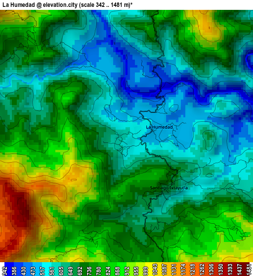
Below is the Elevation map of La Humedad, which displays elevation range with different colors. Scale of the first map is from 342 to 1481 m (1122 to 4859 ft) with average elevation of 716.3 meters (=2350 ft) [note 1]
These maps also provides idea of topography and contour of this city, they are displayed at different zoom levels. More info about maps, scale and edge coordinates you can find below images.
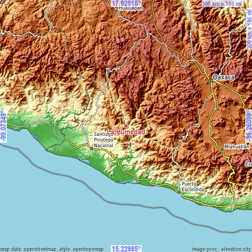
| \ | Map #1 | Topo.Map |
| Scale [m] | 342..1481 m | × |
| Scale [ft] | 1122..4859 ft | × |
| Average | 716.3 m = 2350 ft | × |
| Width | 9.37 km = 5.8 mi | 299.7 km = 186.2 mi |
| Height | 9.37 km = 5.8 mi | 299.7 km = 186.2 mi |
| ↑Max Latitude | 16.624333° | 17.92515° |
| Latitude at center | 16.58222° | 16.58222° |
| ↓Min Latitude | 16.540098° | 15.22985° |
| ← Min Longitude | -97.711185° | -99.07349° |
| Longitude center | -97.66724° | -97.66724° |
| →Max Longitude | -97.623295° | -96.26099° |
Nearby cities:
Cities around La Humedad sort by population:
• Santa Catarina Mechoacán elevation 284 m
32.8 km,  213°
213°
• Tataltepec de Valdés 382 m
33.4 km,  157°
157°
• San Lorenzo 240 m
30.3 km,  226°
226°
• San Agustín Chayuco 259 m
25 km,  216°
216°
• Santiago Ixtayutla 709 m
2.3 km,  138°
138°
• San Miguel Tetepelcingo 230 m
32.3 km, 230°
• San Juan Cabeza del Río 1128 m
29.8 km,  309°
309°
• Zaragoza 1759 m
16.5 km, 305°
• La Reforma 845 m
19.6 km,  283°
283°
• Santiago Amoltepec 1702 m
19.4 km,  69°
69°
• Santiago Tetepec 271 m
30.2 km,  196°
196°
• Quinicuena 711 m
16.3 km,  110°
110°
Multilingual:
 En español:
La Humedad elevación 482 m.
 En France:
La Humedad élévation 482 m.
 Auf Deutsch:
La Humedad höhe über dem Meeresspiegel ist 482 m.

Sources and notes:
- [note 1] Map square and city borders are not equal. Map elevation data is calculated only from area inside that square.
- [src 1] Elevation data from geonames database provided with same terms of usage.
- [src 2] The elevation map of La Humedad is generated using elevation data from NASA's 3 arcsec (90m) resolution SRTM data.
- [src 3] Base (background) map © OpenStreetMap contributors tiles are generated by Geofabrik and OpenTopoMap.
Copyright & License:
This La Humedad Elevation Map is licensed under CC BY-SA. You may reuse any part from this page, if you give a proper credit by linking to this URL:
 More info on terms of use page.