Acatlán de Pérez Figueroa elevation
Acatlán de Pérez Figueroa (Oaxaca), Mexico elevation is 140 meters and Acatlán de Pérez Figueroa elevation in feet is 459 ft above sea level [src 1]. Acatlán de Pérez Figueroa is a populated place (feature code) with elevation that is 1174 meters (3852 ft) smaller than average city elevation in Mexico.
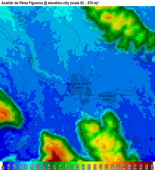
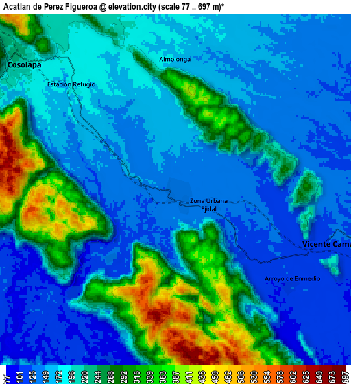
Below is the Elevation map of Acatlán de Pérez Figueroa, which displays elevation range with different colors. Scale of the first map is from 92 to 570 m (302 to 1870 ft) with average elevation of 178 meters (=584 ft) [note 1]
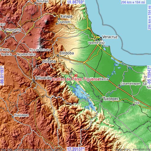
These maps also provides idea of topography and contour of this city, they are displayed at different zoom levels. More info about maps, scale and edge coordinates you can find below images.
| \ | Map #1 | Map #2 | Topo.Map |
| Scale [m] | 92..570 m | 77..697 m | × |
| Scale [ft] | 302..1870 ft | 253..2287 ft | × |
| Average | 178 m = 584 ft | 207.2 m = 680 ft | × |
| Width | 9.27 km = 5.8 mi | 18.53 km = 11.5 mi | 296.5 km = 184.2 mi |
| Height | 9.27 km = 5.8 mi | 18.53 km = 11.5 mi | 296.5 km = 184.2 mi |
| ↑Max Latitude | 18.58139° | 18.623039° | 19.86769° |
| Latitude at center | 18.53973° | 18.53973° | 18.53973° |
| ↓Min Latitude | 18.49806° | 18.45638° | 17.20137° |
| ← Min Longitude | -96.649625° | -96.693571° | -98.01193° |
| Longitude center | -96.60568° | -96.60568° | -96.60568° |
| →Max Longitude | -96.561735° | -96.517789° | -95.19943° |
Nearby cities:
Cities around Acatlán de Pérez Figueroa sort by population:
• Cosolapa elevation 222 m
10.8 km,  308°
308°
• Vicente Camalote 122 m
8.5 km,  109°
109°
• Tezonapa 235 m
11.2 km, 312°
• Motzorongo 267 m
17.3 km, 311°
• Tetela 92 m
15.9 km,  102°
102°
• Laguna Chica (Pueblo Nuevo) 152 m
13.4 km,  271°
271°
• Zona Urbana Ejidal 136 m
1.9 km, 114°
• Arroyo de Enmedio 117 m
7.7 km,  127°
127°
• Ixtacapa el Chico 129 m
15.4 km,  249°
249°
• Almolonga 198 m
9.6 km,  322°
322°
• San Agustín del Palmar 135 m
12.4 km,  258°
258°
• La Junta 109 m
7.6 km,  225°
225°
Multilingual:
 En español:
Acatlán de Pérez Figueroa elevación 140 m.
 En France:
Acatlán de Pérez Figueroa élévation 140 m.
 Auf Deutsch:
Acatlán de Pérez Figueroa höhe über dem Meeresspiegel ist 140 m.
 На русском:
Acatlán de Pérez Figueroa высота над уровнем моря 140 м
Sources and notes:
- [note 1] Map square and city borders are not equal. Map elevation data is calculated only from area inside that square.
- [src 1] Elevation data from geonames database provided with same terms of usage.
- [src 2] The elevation map of Acatlán de Pérez Figueroa is generated using elevation data from NASA's 3 arcsec (90m) resolution SRTM data.
- [src 3] Base (background) map © OpenStreetMap contributors tiles are generated by Geofabrik and OpenTopoMap.
Copyright & License:
This Acatlán de Pérez Figueroa Elevation Map is licensed under CC BY-SA. You may reuse any part from this page, if you give a proper credit by linking to this URL:
 More info on terms of use page.