Motzorongo elevation
Motzorongo (Veracruz, Tezonapa), Mexico elevation is 267 meters and Motzorongo elevation in feet is 876 ft above sea level [src 1]. Motzorongo is a populated place (feature code) with elevation that is 1047 meters (3435 ft) smaller than average city elevation in Mexico.
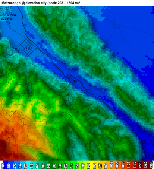
Below is the Elevation map of Motzorongo, which displays elevation range with different colors. Scale of the first map is from 208 to 1304 m (682 to 4278 ft) with average elevation of 499.7 meters (=1639 ft) [note 1]
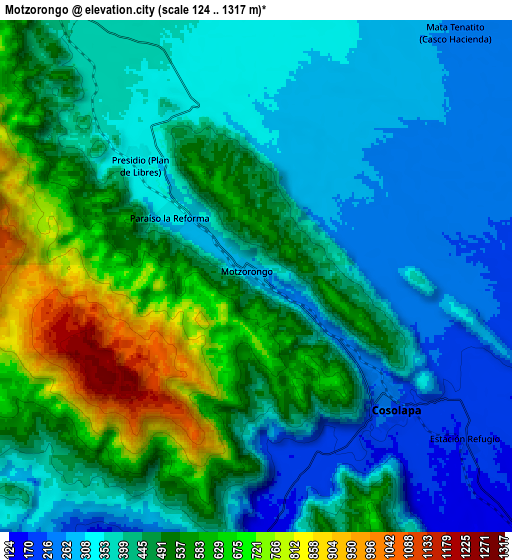
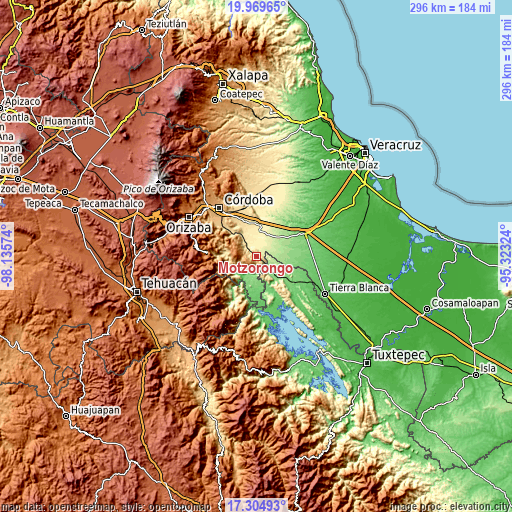
These maps also provides idea of topography and contour of this city, they are displayed at different zoom levels. More info about maps, scale and edge coordinates you can find below images.
| \ | Map #1 | Map #2 | Topo.Map |
| Scale [m] | 208..1304 m | 124..1317 m | × |
| Scale [ft] | 682..4278 ft | 407..4321 ft | × |
| Average | 499.7 m = 1639 ft | 441.5 m = 1448 ft | × |
| Width | 9.26 km = 5.8 mi | 18.52 km = 11.5 mi | 296.3 km = 184.1 mi |
| Height | 9.26 km = 5.8 mi | 18.52 km = 11.5 mi | 296.3 km = 184.1 mi |
| ↑Max Latitude | 18.684154° | 18.725779° | 19.96965° |
| Latitude at center | 18.64252° | 18.64252° | 18.64252° |
| ↓Min Latitude | 18.600875° | 18.55922° | 17.30493° |
| ← Min Longitude | -96.773435° | -96.817381° | -98.13574° |
| Longitude center | -96.72949° | -96.72949° | -96.72949° |
| →Max Longitude | -96.685545° | -96.641599° | -95.32324° |
Nearby cities:
Cities around Motzorongo sort by population:
• Cosolapa elevation 222 m
6.6 km,  135°
135°
• Tezonapa 235 m
6.2 km,  129°
129°
• Omealca 423 m
13 km,  333°
333°
• La Providencia 402 m
13 km,  340°
340°
• Presidio (Plan de Libres) 340 m
6.2 km,  313°
313°
• Laguna Chica (Pueblo Nuevo) 152 m
11.1 km,  181°
181°
• Mata Tenatito (Casco Hacienda) 261 m
11.3 km,  38°
38°
• Almolonga 198 m
8.1 km,  117°
117°
• San Agustín del Palmar 135 m
14 km, 176°
• Palmar Grande 133 m
15.1 km,  200°
200°
• Mata Naranjo 336 m
15.1 km,  6°
6°
• Rancho Nuevo 130 m
12.1 km, 204°
Multilingual:
 En español:
Motzorongo elevación 267 m.
 En France:
Motzorongo élévation 267 m.
 Auf Deutsch:
Motzorongo höhe über dem Meeresspiegel ist 267 m.

Sources and notes:
- [note 1] Map square and city borders are not equal. Map elevation data is calculated only from area inside that square.
- [src 1] Elevation data from geonames database provided with same terms of usage.
- [src 2] The elevation map of Motzorongo is generated using elevation data from NASA's 3 arcsec (90m) resolution SRTM data.
- [src 3] Base (background) map © OpenStreetMap contributors tiles are generated by Geofabrik and OpenTopoMap.
Copyright & License:
This Motzorongo Elevation Map is licensed under CC BY-SA. You may reuse any part from this page, if you give a proper credit by linking to this URL:
 More info on terms of use page.