Acaxochitlán elevation
Acaxochitlán (Hidalgo), Mexico elevation is 2258 meters and Acaxochitlán elevation in feet is 7408 ft above sea level [src 1]. Acaxochitlán is a seat of a second-order administrative division (feature code) with elevation that is 944 meters (3097 ft) bigger than average city elevation in Mexico.
Below is the Elevation map of Acaxochitlán, which displays elevation range with different colors. Scale of the first map is from 1822 to 2535 m (5978 to 8317 ft) with average elevation of 2242.5 meters (=7357 ft) [note 1]
These maps also provides idea of topography and contour of this city, they are displayed at different zoom levels. More info about maps, scale and edge coordinates you can find below images.
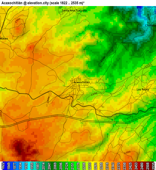
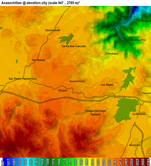
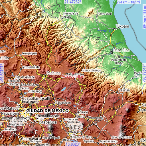
| \ | Map #1 | Map #2 | Topo.Map |
| Scale [m] | 1822..2535 m | 947..2765 m | × |
| Scale [ft] | 5978..8317 ft | 3107..9072 ft | × |
| Average | 2242.5 m = 7357 ft | 2198.4 m = 7213 ft | × |
| Width | 9.17 km = 5.7 mi | 18.35 km = 11.4 mi | 293.5 km = 182.4 mi |
| Height | 9.17 km = 5.7 mi | 18.35 km = 11.4 mi | 293.6 km = 182.4 mi |
| ↑Max Latitude | 20.199138° | 20.240375° | 21.47232° |
| Latitude at center | 20.15789° | 20.15789° | 20.15789° |
| ↓Min Latitude | 20.116631° | 20.075361° | 18.8323° |
| ← Min Longitude | -98.245665° | -98.289611° | -99.60797° |
| Longitude center | -98.20172° | -98.20172° | -98.20172° |
| →Max Longitude | -98.157775° | -98.113829° | -96.79547° |
Nearby cities:
Cities around Acaxochitlán sort by population:
• Tepepa elevation 2193 m
4.1 km,  129°
129°
• Santa Ana Tzacuala 2214 m
4.5 km,  356°
356°
• Los Reyes 2262 m
3.9 km,  94°
94°
• Santa María Asunción 2194 m
7.2 km,  267°
267°
• San Mateo 2291 m
5.4 km,  300°
300°
• Chimalapa 2044 m
5.5 km,  52°
52°
• Tlacomulco 2105 m
8.5 km, 93°
• San Pedro Tlachichilco 2194 m
6.5 km, 273°
• San Francisco Atotonilco 1782 m
6.6 km, 51°
• Zacacuautla 2200 m
7 km,  335°
335°
• Chachahuantla 1744 m
8.7 km,  55°
55°
• Tlacpac 2307 m
1.9 km,  237°
237°
Multilingual:
 En español:
Acaxochitlán elevación 2258 m.
 En France:
Acaxochitlán élévation 2258 m.
 Auf Deutsch:
Acaxochitlán höhe über dem Meeresspiegel ist 2258 m.

Sources and notes:
- [note 1] Map square and city borders are not equal. Map elevation data is calculated only from area inside that square.
- [src 1] Elevation data from geonames database provided with same terms of usage.
- [src 2] The elevation map of Acaxochitlán is generated using elevation data from NASA's 3 arcsec (90m) resolution SRTM data.
- [src 3] Base (background) map © OpenStreetMap contributors tiles are generated by Geofabrik and OpenTopoMap.
Copyright & License:
This Acaxochitlán Elevation Map is licensed under CC BY-SA. You may reuse any part from this page, if you give a proper credit by linking to this URL:
 More info on terms of use page.